How's Your
River
×
Explore
Explore Map
Water Bodies
Gauges
Access Sites
Tidal Stations
Whitewater
Pricing
Login
Sign Up
Hazard Warning:
Hazard information may be user-submitted and unverified. Conditions change frequently. Always scout rapids and obstacles yourself.
Whitewater
Wyoming
Encampment - State Line to Encampment (canyon)
flatwater
Hazard
WY
Class II
flatwater
Encampment - State Line to Encampment (canyon) (WY)
Monitor this Rapid
Water Body
This Run
Map
Other Rapids
Gauge
Weather
Directions
Gauge Conditions
Encampment River at Mouth, near Encampment, WY
Downstream
Primary
Runnable: 300.0 – 1,200.0 CFS
Data from
American Whitewater
&
USGS
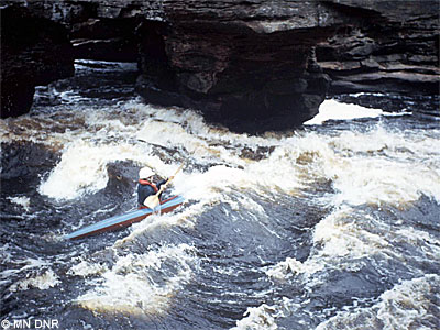
Photo
Photo courtesy of
American Whitewater
Description
The rapids will slowly decrease in diffuculty and regularity after damnation. By the time you are at mile 10 there is nothing but mellow Class II left...
Location
Radar
Counties
Cell
Verizon
AT&T
T-Mobile
Dark
Satellite
Terrain
Other Rapids on This Run (5)
Rapid
II
Put-In
0.0 mi
Rapid
IV
Class IV
3.0 mi
Waterfall
V
Damnation Alley
5.0 mi
Rapid
IV
Continuous Rapids
5.1 mi
Rapid
II
take-out
15.0 mi
Type
Hazard
Difficulty
Class II
Mile Marker
10.0 mi
Directions
Navigate
View Full Run
State Line to Encampment (canyon)
Encampment
II-V
15.0 mi
Hazard
— Exercise extreme caution in this area.
Current Conditions
5-Day Forecast
Whitewater data from
American Whitewater
flatwater