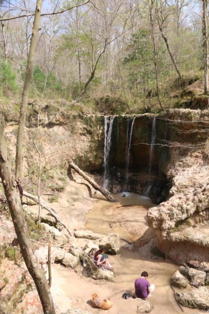
01. 40' Waterfall to confluence with Slate River
Daisy Creek
Linked via: Unknown Synced 6mo ago
Gauge Conditions
Runnable: 500.0 – 2,500.0 CFS
Optimal flows: 700 - 2500 (2013 Gunnison Flow Study). Slate gauge has moved downstream, possibly affecting correlated flow range.
Data from American Whitewater & USGS
Run Map
Description
Daisy Creek is one of the classic creeks in Crested Butte and like most of the whitewater in the area is short, sweet, and steep. Because of its sliding drops and waterfalls, it is often described as a combination between the Upper East and OBJ but in a smaller riverbed. Also like most of the creeks in Crested Butte, the window for this run is very narrow and is only at runnable flows around peak runoff.
As you hike down to the river, you will see a large, unrunnable 40 footer that you will want to put in below. The Run kicks off into a mancos shale gorge filled with a series of ledge drops and slides. As you begin to exit the gorge, be aware that there is a fifteen-foot waterfall downstream called Big Wood Falls. Eddy out and scout as the landing is shallow and rocky in places and you want a good flat boof.
After Big Wood Falls, the river eases up to the last rapid called Rip Your Head off. This rapid has been responsible for dealing out some pain so be sure to give it a good scout.
To access Daisy, drive up a mile and a half a mile past the put in for the Slate (to get to the Slate put-in, turn left on Slate River Road across from the cemetery right after you leave town on the road to the ski area and drive to the marked FR 754 and go down to a gravel bar upstream of the OBJ campground and the put-in is about two miles up the Slate River Road where the terrain flattens out). Just after the confluence of Daisy and the Slate, look to the left for a road that follows up the river left side of Daisy. Leave your shuttle near the river crossing and continue up the road for about a mile. Park at the bottom end of a meandering section of the creek. The road to the put-in is 4X4, and you can optionally just leave a shuttle vehicle at the takeout and just hike to the put-in and scout as you go.
The Quadruple Crown: Because of the short length and proximity of the Crested Butte creeks, all four of them can be run in the same day. The East River is the best to start out with; it has the largest flow and the least gradient of the four. Next in line is Daisy Creek. Just continue downstream after Daisy to the confluence with the Slate River; there will be about 1/2 mile of slack water until the first rapid. The takeout for the Slate River is the same as Oh Be Joyful Creek, so just walk up to the OBJ put-in from there.
Waterfalls (3)


Hazards & Portages (1)
Caution: The following locations may require scouting or portaging. Always check current conditions.
Difficulty
Class V
Length
0.7 mi
Gradient
290 ft/mi
Rapids
0
1 Hazard
Access Points
Shuttle Info
**To get there:** Take a left and cross the Slate before reaching Pittsburg. This crossing is much shallower than at the OBJ; I've seen a Subaru AWD and an Audi Quattro make it across, but the same risks apply. Make sure it isn't deep enough to suck water into your engine. There is some private property near the creek so please respect no trespassing signs. About a mile up the road you may notice a faint trail leading to the left, or a rock ledge that continues level. Take this to get to the put-in. Hike down to the base of the 40' waterfall, the drop just below it is clogged with wood so you may want to put in below it too. Take out before the confluence with the Slate if you don't plan on running it also.
Difficulty Classes
I Easy
II Novice
III Intermediate
IV Advanced
V Expert/Extreme
VI Unrunnable
Current Conditions
5-Day Forecast
Whitewater data from
American Whitewater
American Whitewater