05. Dillon Falls to Aspen
Linked via: Proximity 94% confidence Synced 6mo ago
Gauge Conditions
Runnable: ? – ? CFS
Approximate reading: This gauge is 1.9 miles away on Deschutes. Use as a general reference only.
Data from American Whitewater & USGS
Run Map
Description
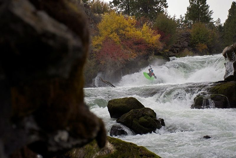
This run is really just one rapid. Dillon Falls consists of a 10-12 foot ledge that leads immediately into a 1/4 mile long canyon. Dillon is runnable year round, but the lines on the falls itself vary widely depending on the water level.
At winter flows (500 to 1100 cfs) the normal line on the falls is far right. After a tricky entry you ride down a narrow shelf and off a 6 foot auto-boof. It's a tough line to nail. Lots of boaters fall off the left side of the flake into the horseshoe, but nobody seems to actually get stuck. A boof line on the far left is also an option. This line is easier to hit, but the consequence is higher, because of a rock shelf that you could potentially land on.
At summer flows (1700 and up) the line is far left, boofing one of 3 fingers on the shelf. In between levels can be the most difficult levels for the falls. The right line closes out, due to a large hole in the lead in. The left line has a small margin for error, because the shelf does not yet have enough water flowing over it.
Immediately after the falls is the river-wide "Dill Hole". This one deserves your respect at all levels. It is biggest in the center of the river. At low water, you can avoid the hole far right, sub out through the far left, or boof it down the middle. If you choose to take the hole on, it is a boof or swim situation. Many boaters have taken major beatdowns in Dill Hole and it has definitely caused its fair share of swims. At high water, a seam develops on the far left. Not as many people get stuck at high water, but it still flips a high percentage of paddlers.
After the Dill Hole, the canyon continues for a few hundred yards. At low water, it is read and run class IV. At high water, it is a rowdy big water slalom, moving left, right, and back to the left to avoid 3 big holes.
Dillon Falls at summer flows: https://vimeo.com/70447219
Dillon and Lava at winter flows: https://vimeo.com/53766770
Logistics: Take Highway 372 out of Bend and at mile 7.6 turn onto Forest Road 41
At mile 1.6 on Forest Road 41 turn left onto Forest Road 4100-700. Continue 0.3 mile to a junction and stay right to remain on 4100-700 and in 1.0 mile you will reach the river at Aspen that serves as the take-out.
At mile 2.6 on Forest Road 41 turn left on Forest Road 4100-600 and continue 0.8 miles down to the river and the Dillon Falls Day Use Area. Dillon Falls is located just downstream.
Waterfalls (1)
Difficulty
Class IV+
Length
1.3 mi
Rapids
0
Access Points
Difficulty Classes
I Easy
II Novice
III Intermediate
IV Advanced
V Expert/Extreme
VI Unrunnable
Current Conditions
5-Day Forecast
Whitewater data from
American Whitewater
American Whitewater