06. Scrambled Egg Bend to 89
Linked via: Proximity 97% confidence Synced 6mo ago
Gauge Conditions
Runnable: 460.0 – 3,000.0 CFS
Pacificorp gauge: 140 to 240
Data from American Whitewater & USGS
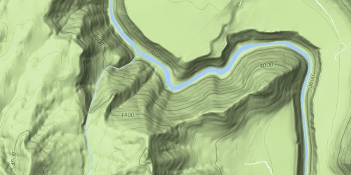
Run Map
Run Time Estimate
Select put-in and take-out to estimate time.
Unlock Advanced Trip Planning
See wind-adjusted speed maps, forecast planning, and detailed time estimates.
Sign in to generate an AI timing estimate for this run.
Whitewater timing varies with scouting, portages, and group pace. Use as a planning baseline.
Description
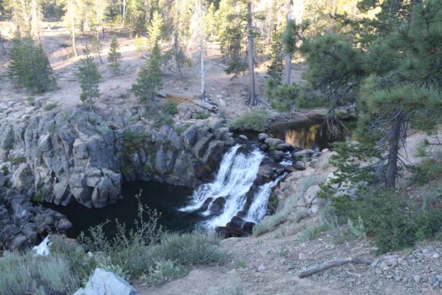
This is the classic Weber whitewater run. The Eggs are a unique boating experience indeed. The put in is, well interesting, as are the drops themselves. The run itself is short with a nice warmup in the lead-in and the bend, then a drop that can surprise you, some boogie water, then three main ledge drops and a class 2-3 run out. The run can be complicated by various amounts of debris in the water.
The put-in for the run is accessed from the eastbound I-84 rest area before Mountain Green. From the rest area, take a right and drive downstream and park by the dam. Walk along the fence a 100 yards downstream from the parking to the designated fisherman's access to put in. Paddle under I-84, and in a 1/4 mile get out right if you want to scout the bend. You can scout the bend and the 3 drops at once, or paddle the bend and get out river right again to scout the drops, and set safety if desired.
At lower flows, the run is technical. The low water line usually enters left by a large pipe, then moves center, then right (past the left cave eddy which makes a good breather at medium flows), then a move left in the bend. As it approaches 1500 it becomes much more pushy, sticky and challenging. The second drop is often the stickiest. Its possible to portage the first two drops and seal launch in below the second or third drop if you don't like the looks of the first two. A swim would result in a very long time in the water at these flows and safety is hard to set from the right bank for the bend; easier for the drops. The runout below the drops becomes nice III/IV- at high flows; its too bad there is no easy access to putin down there. It is possible to portage the entire bend and drops, to keep a high water run in the IV- range.
At the end of the Canyon, just past the powerhouse on river right, be sure to get out on river-left just upstream of the recently-rebuilt diversion dam. After getting out you can either walk downstream on the Forest Service road all the way to the take-out parking area, or walk a couple hundred feet and put in below the spot where some water often re-enters the river and paddle to the take-out. Do not touch and give some space to the canal relate infrastructure including the fencing. When the diversion gates are open some people paddle through them though this is not recommended.
The takeout is just east (upstream) of where Route 89 crosses I-84. Take 89 south to the first exit and turn left. There is a fisherman's access and an old bridge. Hazard: Immediately below the old bridge is a potentially deadly diversion dam. Be aware of this and get out above it--especially at higher flows. _Do not block gates or traffic when you pick a parking spot._
_There are several spots along I-84 that look good for parking, these areas are illegal to park at! If you park there you could get a ticket. Utah Code 41-6a-1401 (ix)_
There is now realtime flow information for the run here that was negotiated by American Whitewater and provided by the power company: https://www.pacificorp.com/community/recreation/water-release/weber-river.html, which is more accurate than the gage depicted elsewhere on this page.
Flow forecast:
https://www.cbrfc.noaa.gov/dbdata/station/flowgraph/flowgraph\_hc.html?id=GATU1&linear\_flow=0
In regards to flows and runnable levels. I have run the entire run at 230cfs ELF (Extremely Low Flow) boating, very doable. Some have run laps on the Bend at 180. This was off the USGS gauge with no power diversion and no water in the Canal. I would rate it as Class IV- rock dodging. Really good to get to know the lines.
This all changes when the power plant is taking its 320cfs and the Canal Company takes its 100cfs. So let me give a brief example for a summer flow.
The USGS gauge at Gateway is 600cfs. The power plant is full power taking 320cfs leaving 280cfs in the bend and the drops down to the power plant. This is where the 320 cfs comes back in, it’s also where the Canal company with the gates lower will take out 100cfs +/- thus leaving 500cfs for the remaining of the run. This number can be seen on the USGS gauge at Hwy 89.
So when looking at the gauges. Both USGS and the Pacific Corp gauge you can now determine if it is all runnable.
Rapids in this Run (5)
Waterfalls (3)


Hazards & Portages (1)
Caution: The following locations may require scouting or portaging. Always check current conditions.
Difficulty
Class III-IV+
Length
2.7 mi
Rapids
5
1 Hazard
Access Points
Difficulty Classes
I Easy
II Novice
III Intermediate
IV Advanced
V Expert/Extreme
VI Unrunnable
Current Conditions
5-Day Forecast
Whitewater data from
American Whitewater
American Whitewater