08. Bridalveil
Linked via: Proximity 97% confidence Synced 6mo ago
Gauge Conditions
Runnable: ? – ? CFS
Approximate reading: This gauge is 9.9 miles away on Provo. Use as a general reference only.
Data from American Whitewater & USGS
Run Map
Run Time Estimate
Select put-in and take-out to estimate time.
Unlock Advanced Trip Planning
See wind-adjusted speed maps, forecast planning, and detailed time estimates.
Sign in to generate an AI timing estimate for this run.
Whitewater timing varies with scouting, portages, and group pace. Use as a planning baseline.
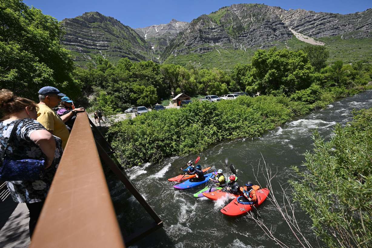
Description
High water warning: in June 2023, this section is running unusually high, with 1700+ on the Harbor Drive gauge. Bridalveil should be considered class 4+ above 1300 cfs, with higher consequence swims. There have been 6 lost kayaks on this section in 15 days, and that is just what has been reported. One swimmer was concussed, and did not remember the swim. Note that there is a mandatory portage footbridge at Glenn Canyon Park. Putting in downstream of this footbridge is a safer run, which still has fun big wave trains.
A Utah classic, when it runs. There is a lot of wood on this run, and trees can fall or collect riverwide occasionally, especially at the first drop which can be bank scouted close to the putin parking.
The scenery is awesome, and the water in the spring is clean and cold.
There is a frontage road from Nuns Park to the putin, which allows for scouting that section.
From the putin parking lot, bank scout the first drop, which often has large logs on the right.
Below there are some good surf waves, mostly on the fly.
Below a couple of the best surf waves, the river bends left and a rocky drop is next. This spot often collects wood, and is a good spot to bank scout, since there are not good eddies for boat scouting.
You will pass under a couple footbridges at Bridalveil Falls, then the rapids pick up as you approach the crux.
A traditional line is to move left above the crux rocks, although it can still be rocky after moving left. Right lines are also possible, as well as an S move through the rocks. The frontage road has the best view of the crux, looking downstream; the brush obscures all other views of the crux.
Then you come to the Nuns Park area, which can serve as a putin if you want to keep it to class 3.
There was avoidable wood in a number of places below Nuns Park, in May 2020.
There are a couple other on the fly surf waves if you keep your eyes open; one is right after a white footbridge.
Takeout in the pond at Mt Timpanogos Park. Do not miss the takeout as there is a dam overflow at the end of the pond.
The flow of Bridalveil is poorly gauged.
Upstream we can tell the outflow from Deer Creek reservoir, 'Lower Provo' section here:
Downstream we can see the USGS 'Provo@Provo', here:
https://waterdata.usgs.gov/monitoring-location/10163000/#dataTypeId=continuous-00065-0&period=P7D
But there are so many diversions, the Deer Creek outflow and the lower Provo gauge don't tell us much about BV.
This link has some info:
Add the
Murdock CUWCD Spill-Over-The-Weir
and
800 North Provo River Aqueduct Flow.
And 'add 20 cfs you have the flow for BV' (from Cody's trip report).
200 cfs < 3+/4- < 800 < 4 < 1300 < 4+
Rapids in this Run (3)
Hazards & Portages (2)
Caution: The following locations may require scouting or portaging. Always check current conditions.
Difficulty
Class III-IV+
Length
3.7 mi
Rapids
3
2 Hazards
Access Points
Difficulty Classes
I Easy
II Novice
III Intermediate
IV Advanced
V Expert/Extreme
VI Unrunnable
Current Conditions
5-Day Forecast
Whitewater data from
American Whitewater
American Whitewater