1) Greenville to NH Rt. 101 Bridge
Linked via: Proximity 72% confidence Synced 6mo ago
Gauge Conditions
Runnable: 400.0 – 3,000.0 CFS
Upper limit for best boatability uncertain. Please help your fellow boaters with a comment or report.
Data from American Whitewater & USGS
Run Map
Run Time Estimate
Select put-in and take-out to estimate time.
Unlock Advanced Trip Planning
See wind-adjusted speed maps, forecast planning, and detailed time estimates.
Sign in to generate an AI timing estimate for this run.
Whitewater timing varies with scouting, portages, and group pace. Use as a planning baseline.
Description
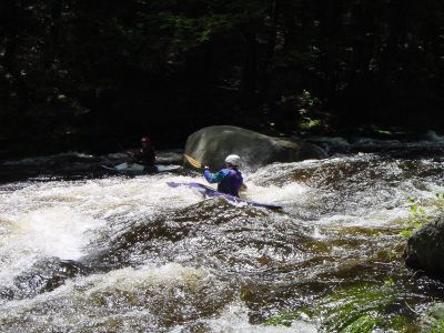
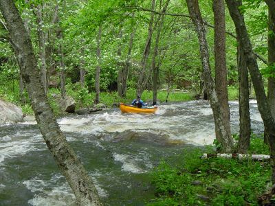
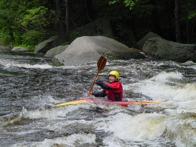
The Souhegan is a popular spring run. The river is small only about 30' on average. The first mile is steeper (class II-III) once you pass the bridge the river mellows out to a class II. This bridge crossing is the access for the easier section below. The entire river is wooded and scenic with only an occasional view of the road. The Souhegan is narrow and has many blind corners, because of this look out for trees and strainers especially early in the season before local boating clubs clear them out.
### Technical info
```
Put in elevation........690'
Take out elevation......435'
Total drop..............255'
Average drop/mile.......59'
Distance................4.3 miles
River width average.....30'
1st mile drop...........85'
2nd mile drop...........65'
3rd mile drop...........45'
4th mile drop...........45'
4.3 mile drop...........15' (50'average)
River geology...........schists, small boulders, some ledge
River water quality.....good, clarity; good to neutral.
Scenery.................excellent, route 31 occasionally visiable.
Wildlife................Occasional deer, merganzers, beaver, hawks
```
Rapids in this Run (4)
Playspots (3)
Difficulty
Class II-III
Length
5.6 mi
Gradient
59 ft/mi
max 85
Rapids
4
Access Points
Shuttle Info
### Class II (Lower) Put in
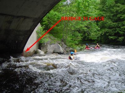
From Manchester NH take state route 101 west approximately 25 miles. Just pass the town of Wilton state route 31 merges with 101. Continue west on 101/31. Take a left when route 31 diverges left from 101 just after the Monadnock Spring Water plant on your left. Proceed for approximately 4.75 miles to the put-in where the road crosses over the river; look for a sign by the pull-off "Heald Tract", and "Society for the Protection of New Hampshire Forests". The Paddlers' Gage is here, on the downstream side of the river-left bridge abutment.
### Class III (Upper) Put-in
From the lower put-in, proceed another 0.9 miles beyond the bridge until you come up to a small clearing on the right. A sign is located at the head of an old access road welcoming fishermen and recreational users. The put in is 100 yard carry down this road at the site of an old hydro dam. Note: Do not put in further upstream at the Greenville bridge. There is a short constricted class IV-V gorge located between there and the usual put in by the old hydro dam. To view the gorge drive up the hill a short distance \[upstream\] from the put-in; it is located directly behind a small welding shop.
The original Paddlers' Gage is here at the upper put-in on the side of the remains of a concrete wall.
### Upper Take-out
Head back in the direction you just came from back to the intersection with route 101. The take out is located near the Monadnock Spring Water plant. Be careful of where you park here the owners of the water bottling plant do not allow parking on their property. This also applies to the field next to the plant.
Paddlers may take out on river left on the upsteam side of the Issac Frye Highway Bridge which is the road that crosses the river just upsteam of the Monadnock Spring Water Plant. There is a wire fence paralleling the road that delimits the highway right of way which paddlers can use (walk between the fence and the highway.) The area on the other side of the fence is private property.
Paddlers may park along the road and off the asphalt along the intersection of Issac Frye Highway, Gibbons Highway (Routes 101/31), and Mansur Road. The three roads form a triangle shaped intersection. (Note: NH State Law requires all parked cars to be completely off the asphalt or risk a ticket.) Be aware there are "No Trespassing" signs posted there by Monadnock Spring Water; those signs are at the edge of Monadnock Spring Water property line, and indicate that you cannot park behind them. The public has the legal right to park there, in front and up-to the property line as demarked by the no-trespassing signs. (In fact, paddlers may use the signs as a confirmation of where it _**IS**_ legal to park.) The NH highway minimum legal width is 50 feet; the highway right-of-way on Mansur Road extends 25 feet from the center line. The right-of-way on Issac Frye Highway extends 30 feet from the center line. There has been substantial legal work performed to secure paddlers' right to park there and to access a navigable river, and those rights will be defended. As always, please keep the area clean and don't pollute! Don't give local property owners a reason to complain.
Click here for a copy of the **[letter from the NH DOT confirming paddler access to the highway Right-Of-Way](http://www.americanwhitewater.org/content/Photo/detail/photoid/50551/).**
### Lower (Alternate) Take-Out
There is an alternate take out about 3/4 miles downstream on Intervale Rd., the side road off Rts 31/101 just upstream from where the Souhegan goes under the 101 bridge. This is private property on a quiet residential road. Please be considerate so that we don't lose the cooperation of the neighbors. Park on the side of the road away from the houses and out of the right of way. The paddle from the Issac Frye bridge is mostly quick water and class I.
_Thanks to Tom Quarles and Tom Todd for clarifying the above info._
Difficulty Classes
I Easy
II Novice
III Intermediate
IV Advanced
V Expert/Extreme
VI Unrunnable
Current Conditions
5-Day Forecast
Whitewater data from
American Whitewater
American Whitewater