1. Rimrock Reservoir to Windy Point Campground (Upper)
Linked via: Proximity 62% confidence Synced 6mo ago
Gauge Conditions
Runnable: ? – ? CFS
Approximate reading: This gauge is 15.0 miles away on Tieton. Use as a general reference only.
Data from American Whitewater & USGS
Run Map
Description
Busy raft traffic, a highway paralleling the river, and the flush of a dam release with few eddies make this a run many might pass up. As one of the few places with dependable whitewater in the waning days of summer, however, boaters from across the state converge on this popular late summer run. The river comes to life with the annual flip-flop typically occurring on our around the weekend after Labor Day. At that time, flows from the upper Yakima reservoirs are reduced for the benefit of spawning salmon and flows on the Tieton are increased to serve irrigation interests downstream providing good boating through much of September. The Tieton is also often boatable from mid-May into mid-July when the dam fills up and spills inflow. The canyon is beautiful and the water comes at a time of year when decent whitewater can be hard to find making it the last summer run for many.
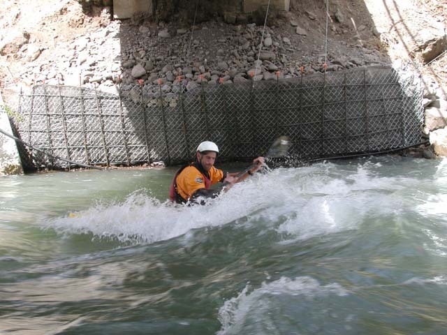
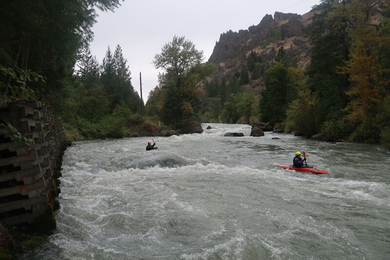
Most of the run is continuous class II and III rapids. This is not, however, a great beginner run. Lots of brush along the banks and the continuous nature of the run present a real challenge for those with less than solid boating skills. Rescues can be difficult so be sure to go with a strong crew. The first half of the run is characterized by fast water through shallow boulder gardens. The pace begins to change slightly with the approach of a low-head dam about halfway through the run. The dam is well marked by signs on river left at 1000' feet that can be seen from the road (most easily when driving in the downstream direction) near mile marker 172. A couple smaller side channels appear here, but the best option is to continue with the channel containing most of the flow as it heads towards river right. Those with solid boating skills should have no problem pulling out on river left once the dam is in sight. The dam can be run, but there are a couple of spots that wouldn't be much fun so if you have any doubts take the conservative route along the portage trail on river left. This is a low-head dam and deserves your full respect. Shortly after the dam you will boat past some cabins on the river left bank and pass through the House Rock section. This is one of the more significant class III rapids on the run.
Some boulder gardens and slightly more technical sections follow as you come up to the steel I-beam bridge behind Trout Lodge (Highway 12 mile 172.9). The park and play crowd can easily access the bridge from Trout Lodge. This is one of the best play spots on the river. It's not quite the Wenatchee, but it's still good fun.
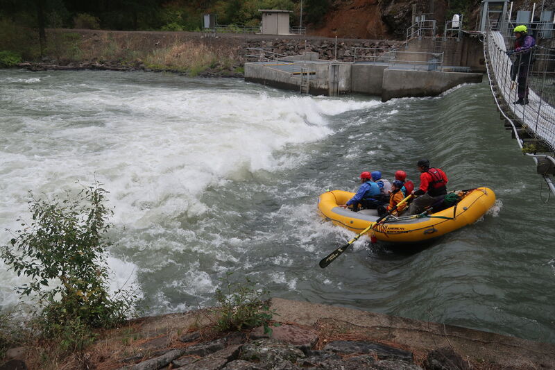
Waffle Wall comes a few short bends in the river downstream from Trout Lodge. This is the main class III rapid on the run where the photographers set up to take pictures of the bus loads of gleeful rafters. Smile for the camera and avoid getting slammed into the retaining wall on river right. A few more short technical sections follow but the pace of the river quickly slows down and passes under two highway bridges, with the downstream one serving as the standard takeout. You can continue farther downstream, but by the time most paddlers get to the bridges they are in the mood to call it a day.
ACCESS:
PUTIN: There are a couple of options extending as far up as the pool at the base of the dam. The most convenient put-in is at mile 166.6 along Highway 12. Other options exist at campgrounds and roadside pullouts.
TAKEOUT: There are also several options for getting off the river. The road parallels the river for the entire run. Convenient take outs that come near the end of most of the fun rapids are found at the bridges (mile 177.1 and mile 176.6 on Highway 12). The downstream of these two bridges has good access to the water and a formalized parking area.
SHUTTLE: This is as easy as it gets. Highway 12 parallels the river. You can nearly always hitch a ride if you need to.
Additional Information:
Bennett, J. and T. Bennett. 1997. A guide to the whitewater rivers of Washington, second edition. Swiftwater Publishing. Portland, OR.
North, D.A. 1992. Washington Whitewater. Mountaineers Books. Seattle, WA.
Rapids in this Run (2)
Hazards & Portages (1)
Caution: The following locations may require scouting or portaging. Always check current conditions.
Difficulty
Class III+
Length
11.6 mi
Rapids
2
1 Hazard
Access Points
Difficulty Classes
I Easy
II Novice
III Intermediate
IV Advanced
V Expert/Extreme
VI Unrunnable
Current Conditions
5-Day Forecast
Whitewater data from
American Whitewater
American Whitewater