1) Road to Wintergreen Ski resort to Moses Hughes Ln.
Linked via: Nhdplus discovery 90% confidence Synced 6mo ago
Gauge Conditions
Runnable: ? – ? CFS
Approximate reading: This gauge is 8.0 miles away on Rockfish. Use as a general reference only.
Data from American Whitewater & USGS
Run Map
Run Time Estimate
Select put-in and take-out to estimate time.
Unlock Advanced Trip Planning
See wind-adjusted speed maps, forecast planning, and detailed time estimates.
Sign in to generate an AI timing estimate for this run.
Whitewater timing varies with scouting, portages, and group pace. Use as a planning baseline.
Description
Upper South Fork Rockfish River
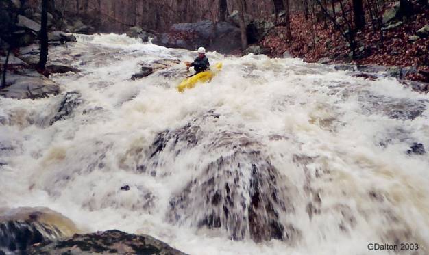
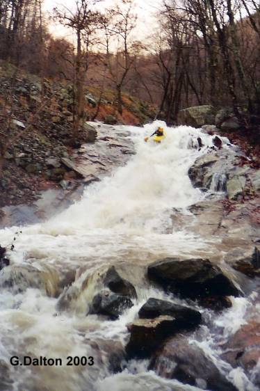
This tiny, busy stream drops steeply off the east face of the Blue Ridge Mountains and runs beside the road that leads to Wintergreen ski resort. The South Rock needs A LOT of rain to go off, but if you catch it right it you are in for a sled run of a creek that can be steeper than some of the ski slopes 800 feet above you up the mountain.
Question:
*What's the best boat to paddle on the South Rockfish?*
Answer:
*Your buddy's boat!*
The 'South Rock' is a full-contact steep creeking experience. If it was a ski hill it would be a black diamond slope, with moguls. Don't be a Jerry, wear elbow pads and a good helmet. You'll be descending rather quickly from the entrance to Wintergreen Ski Resort, down into the southern end of the Rockfish Valley. After a couple of distinct slides at the beginning of the run, you'll find a narrow and fast flowing streambed characterized by continuous dodging between manky tilted boulder gardens and the looming threat of unrunnable strainers around every bend. Be mindful of a low bridge hazard, a set of culverts to negotiate, and a wire fence strainer at the take-out. Buckle up - there is no Ski Patrol to rescue you on this mountain. If this sounds like fun to you, borrow a boat from your buddy and set shuttle.
Shuttle:
Leave a car roadside on Moses Hughes Ln. (715) where it intersects with Beech Grove Rd. (664). Continue up Beech Grove Rd. about 3 miles, paralleling the creek, and watch for the obvious steep slide. That slide is Slide #2 and you can park in the dirt pullout there, or continue up the road another 100-200 yards to park roadside below the entrance to Wintergreen Ski Resort. Please respect private property and only use access at the listed put-ins and the Moses Hughes bridge. The entire run is bordered by private property and people's homes.
Warning:
When the creek was first run in 2006, Gordon and Harris put on the creek with almost no scouting and the last hour of daylight quickly fading away. Somehow, we had a smooth run, with no portages and no wood, and reached the take-out with a little daylight to spare. If we had been a few minutes later we would not have had enough light to see the barbed wire fence strung directly under the take-out bridge. Luckily we were able ro scramble to the bank before tangling with the fence. That fence was replaced in 2025 with a woven wire fence that is about 15' downstream from the Moses Hughes bridge. Scout this fence and the take-out eddy when you set your shuttle. Also take a look at the culverts noted in the river descripton below. They can create logjams and are tight even on a good day. Thirdly, there is a report of a new wooden bridge over the creek that is too low to paddle under - this could be a hazard if present. Please be heads up and watch out for each other on this tight little steep creek. Rock on!
Rapids in this Run (3)
Difficulty
Class IV-V
Length
2.6 mi
Gradient
280 ft/mi
Rapids
3
Access Points
Difficulty Classes
I Easy
II Novice
III Intermediate
IV Advanced
V Expert/Extreme
VI Unrunnable
Current Conditions
5-Day Forecast
Whitewater data from
American Whitewater
American Whitewater