1. Ruby Ranch Road to F.M. 1626 (3 miles)
Linked via: Proximity 96% confidence Synced 6mo ago
Gauge Conditions
Runnable: 150.0 – 1,500.0 CFS
Data from American Whitewater & USGS
Run Map
Description
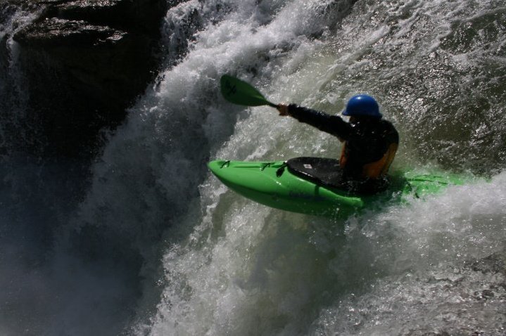
For the first two miles of the run, this stretch of Onion Creek is fairly uneventful, consisting mainly of a few small rapids and wave trains until you get to Barber Falls (see description below.) Both drops of Barber Falls (Winterburg's Freeze and Teardrop Falls) are runnable at a wide variety of levels but increase significantly in difficulty at higher flows. When the first two miles of the run are prime (above 1000 cfs), the falls become much higher-consequence. Typically the falls are ideal between 200-500 cfs, with a first-timer sweet spot at approximately 250 cfs. The remainder of the run below the falls is uneventful, with a couple of boulder gardens and small waves.
Distances and gradient measured using GIS tools in 2015.
The LCRA Hydromet gauge at Buda is a better reference than the USGS gauge at Driftwood (linked above), since Driftwood is quite a few miles upstream.
Ruby Ranch Road Put-in:
In the past, shuttle vehicles for this stretch could not be left at or near Ruby Ranch Road. Local landowners were known to threaten boaters, call police, and even vandalize vehicles, so it was impossible to do this run without a wheelman. Texas Whitewater even suggested that you should be dressed and ready to jump out of the vehicle and immediately put in.
More recent beta from paddlers suggests that this is no longer the case and that vehicles can now be safely parked in the right-of-way of Ruby Ranch Rd. The Northeast (river left, downstream) side of the bridge seems to be a good place to park, because a fence clearly dilineates the right-of-way, and the bridge guardrail is shortest on that side (making it the closest legal parking spot to the creek.) Paddlers should still be as discreet as possible and avoid venturing outside of the right-of-way.
Landowner issues at Barber Falls:
The landowners at river left are militantly opposed to kayakers, and in the past, they have fired warning shots, looked at boaters through a rifle scope from a distance, yelled and threatened boaters from the bank, and filed false police reports claiming that boaters were firing guns in the creek bed. In all of these cases (some of which were captured on video), the Hays Co. Sheriff's Dept. (who was either called by the boaters or by the landowners, depending on the incident) showed up and reassured the boaters that they had a legal right to paddle Onion Creek. In several cases, the landowners were admonished by law enforcement, but thus far, insufficient evidence has existed to press charges against them. PLEASE BE CAUTIOUS OF THESE LANDOWNERS. Video all encounters, but do not speak to them or engage them in any way. If trouble arises, call the Hays Co. Sheriff’s Dept. Video all conversations with law enforcement, and above all else, be respectful. Law enforcement is on our side.
_NOTE:_ If you choose to paddle/portage upstream from the takeout to huck Teardrop Falls, stick to the creek bed and do not trespass.
Takeout logistics:
The easiest takeout is on the northwest (river left, upstream) side of the bridge, but because of the aforementioned landowners, vehicles should not be parked here. Park in the grass along the highway right-of-way on the southeast (river right, downstream) side of FM 1626. To avoid landowner issues, do not venture outside of the highway right-of-way or the creek bed when taking out.
Waterfalls (1)
Difficulty
Class II-III(IV)
Length
3.0 mi
Gradient
24 ft/mi
max 300
Rapids
0
Access Points
Shuttle Info
Note: Shuttle vehicles for this stretch CANNOT be left at or near Ruby Ranch Road. Local land owners have been known to threaten boaters, call police, and even vandalize vehicles. It is a good idea to have a shuttle vehicle drop you off.
Difficulty Classes
I Easy
II Novice
III Intermediate
IV Advanced
V Expert/Extreme
VI Unrunnable
Current Conditions
5-Day Forecast
Whitewater data from
American Whitewater
American Whitewater