1. Surprise Creek to Alpine Falls
Linked via: Proximity 94% confidence Synced 6mo ago
Gauge Conditions
Runnable: 5,000.0 – 7,500.0 CFS
Data from American Whitewater & USGS
Run Map
Run Time Estimate
Select put-in and take-out to estimate time.
Unlock Advanced Trip Planning
See wind-adjusted speed maps, forecast planning, and detailed time estimates.
Sign in to generate an AI timing estimate for this run.
Whitewater timing varies with scouting, portages, and group pace. Use as a planning baseline.
Description
The Top Tye remained relatively unknown despite its easy access from a major state highway and proximity to the greater Seattle area. Guidebooks didn’t mention it until 1998. Through the late '90s, however, this river gained a reputation as one of the premier steep creeks in the region, and paddlers have continued to discover it each season. Thanks to the Twitch video series and local paddlesports photographer Jock Bradley, nearly every paddler in the country has seen images of this incredibly scenic creek. Paddlers often find good flows late into the spring boating season, when sunny skies and warm temperatures light up the forested bedrock canyons. The forest doesn’t qualify as true old-growth, but logging hasn't touched it in decades, and Highway 2, though nearby, barely registers when you’re on the water. This run offers solid Class V creek boating, with most drops allowing easy scouting and portaging at moderate flows.
From the Highway 2 bridge, the river begins with shallow Class II rapids and parallels FR 67. A significant drop near the end of this warm-up, known as Slide Falls, gives paddlers the option to put in just below it. A few paddle strokes downstream, the river leaves sight of FR 67 and plunges over a ledge into a canyon. Double Drop Falls marks the start of this gorge and can be easily scouted from river right. A solid line runs down the left, but you’ll need to recover quickly to catch the eddy below on river left—just above the next horizon line, the Spout.
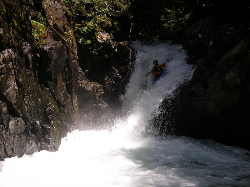
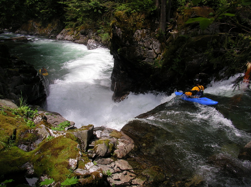
Running Double Drop commits paddlers to the gorge and places them in an eddy above the first of two significant waterfalls. These two drops appear in the opening of the Tye River sequence in *Twitch 2000*. The first, known as The Spout, drops about 15 feet into a right wall. Use the generous bedrock platform on river left to scout or bypass the drop with a seal launch into the foamy pool. The standard line starts on the right and works back to a flake on the left, which launches you clear of the hole at the base and avoids the protruding bedrock on river right.
After only a few paddle strokes, you should aim to catch an eddy on river left before plunging over the next waterfall, Skin So Soft. The standard line runs far right, avoiding rocks at the base of the falls toward the center and left. The drop offers a smooth ride if you set it up correctly. A challenging portage exists on river left, but it requires climbing moves and tricky reentry below.
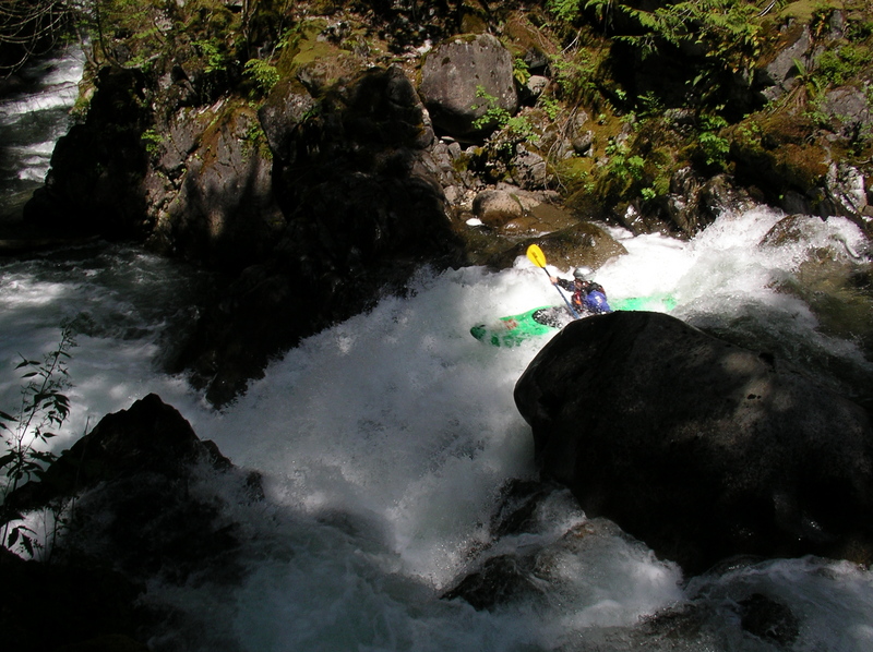
After clearing the two waterfalls, the river flows over several ledges and around boulders before channeling into a flume on the right, signaling the approach to Big Left Turn. Grab the eddy just beyond the corner where the river calms briefly.
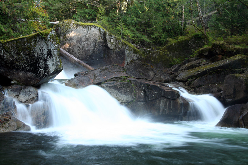
Enjoy a few minutes of easy boulder gardens—occasionally a bit scrapey—before approaching an island with variable wood hazards. In recent years, the left channel has provided the cleaner route. Soon, the river cascades down a fun slide, and Deception Creek enters from the left, marking the start of the Park Section. Upstream on river left, a tourist viewing platform signals the rim of Monkey Cage Falls, a sloping 20-foot drop. As you run this drop, expect cheers and hollers from the tourists above—hence the name. The center or right side typically offers the best line. Avoid the left, where hidden rocks have caused injuries. An easy portage on the left remains available.
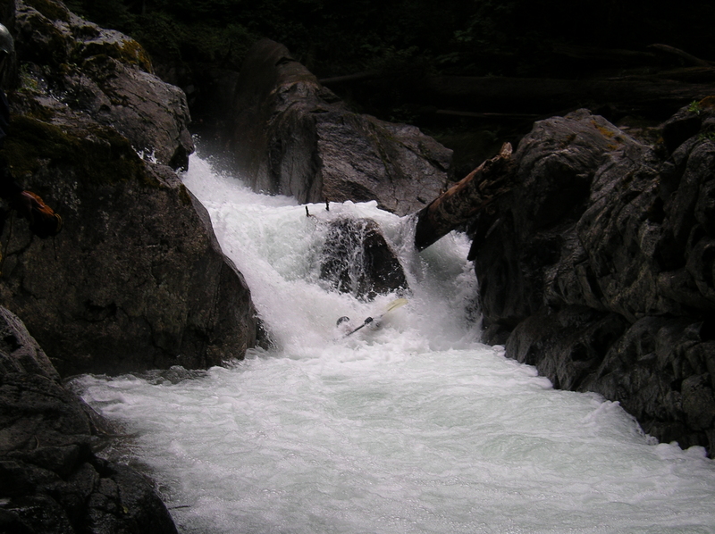
Just downstream, pull out on river right to scout Crack in the Earth—one of the most unique rapids in the region. A short entrance flume leads to a 10-foot ledge that sends the river into a headwall just a few feet downstream. The current then makes a hard 90-degree right turn. The ideal line sails off the right side of the ledge with a right sweep stroke, landing the boof facing downstream. Aim for the preferred right-hand slot past the boulder at the bottom. The current often pushes paddlers toward the left slot, where a deceptively nasty hydraulic lurks. Swims happen often here, so set strong safety. You can also take the far right sneak, which slides you over wet rocks and past the hole. Just 50 yards downstream, the river drops over another ledge with a problematic hydraulic—also worth a safety setup.
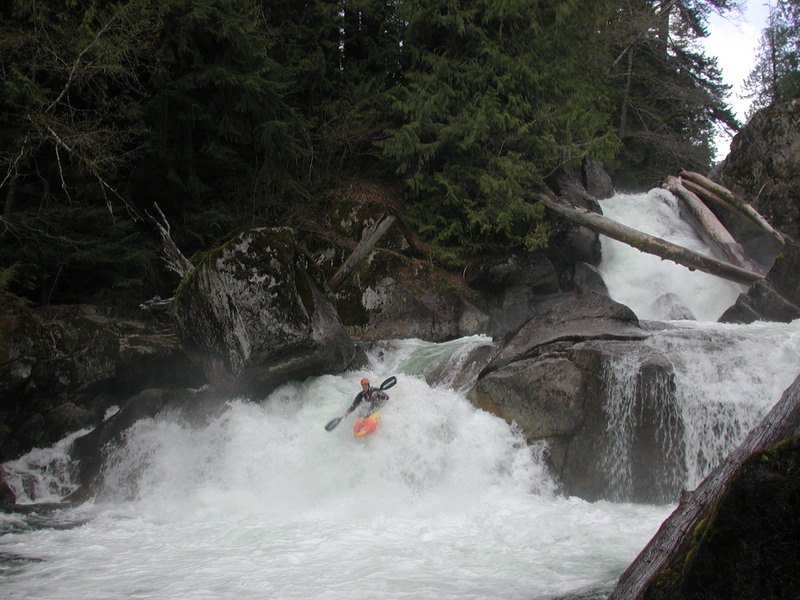
Next comes a series of enjoyable Class III rapids. When you spot the concrete retaining wall for Highway 2 on river left, prepare for Log Choke Falls. Grab an eddy on the right and follow the well-worn portage trail to FR 67 and back down to the pool below. Tao famously ran this drop during the first descent, threading a line through massive old-growth logs jammed in the falls. His second attempt appears in *Twitch 2000*.
Just downstream lies Box Drop, which many consider the best drop on the run. Make sure not to miss this one. The flake sends paddlers into a satisfying boof and clean landing. With Log Choke Falls in the background, the setting feels especially dramatic. Paddlers looking for a short run often start here.
More fun boulder gardens and ledges follow. The next significant horizon line marks 8' Boof, where you’ll want to launch off the left side to avoid the hydraulic. As tributaries feed in, the volume picks up, making the lower rapids feel more powerful than those at the start. Martin Creek joins from the right—once the proposed site of a hydroplant that American Whitewater helped defeat, along with several others in the region.
Scout the next major drop, Paranoia, from above. The river first drops over a tricky entrance, forcing a quick setup for a 10-foot ledge squeezed between bedrock walls. Boof off the left and avoid a strong eddy line above that can throw you off course. A solid rapid follows the pool below.
Shortly downstream, the river flows into Triple Drop—three ledges beginning on the left side. Though they appear tame, holes in the center of each ledge create serious hazards. Depending on the flow, the safest lines lie far right or left. At low flows, adventurous paddlers can try punching through the center.
The final stretch offers more engaging boulder gardens. The gradient steepens as you approach two small canyon sections. In the first, stick to the left before squeezing through a narrow bedrock slot. In the second, start right, then quickly angle away from the wall on river left, which the current slams into at the bottom.
Once you exit the second canyon, the Highway 2 bridge comes into view. Take out at the pool beneath this final rapid and use the river-left trail to reach the road. Just downstream, Alpine Falls lurks—it has been run but the consequences are high if you are not on your line. Avoid drifting past the bridge, as few eddies exist above this dangerous drop. The run downstream continues as the Lower Tye.
Logistics:
The river is paralleled by two roads with Highway 2 running along river left and FR 67 running along river right. FR 67 is a short segment of the old road across the mountain pass starting at Highway 2 mile 55.2 and rejoining it at mile 58.2. You can use either route for your shuttle depending on where you put-in and what you want to scout beforehand. The take-out is at mile 55.3 at a large pullout on the downstream river left side of the Highway 2 bridge. Scout the takeout carefully (takeout at the bridge!) as you don't want to unknowingly drift into the lead in for Alpine Falls (it's been run before, but it's not recommended as consequences could be fatal if you blow your line and end upriver right). To reach the put-in you can head upstream on FR 67. If you just want to run the lower halfof the run you can put-in at the base of Log Choke Falls at FR 67 mile 1.3 where a trail leads down nearc oncrete barriers. For the upper put-in continue up to mile 2.5 where the road approaches the river and offers convenient access. As an alternative you can run your shuttle on Highway 2 and scout the Park Section from the Deception Falls Recreation Area at Highway 2 mile 56.7 to see what you're getting into. Then continue up to Highway 2, cross the Tye at mile 58.2, turn onto FR 67, and head downstream to a convenient put-in of your choosing.
Additional Information:
- Darren Albright's description and several photos by Jock Bradley on the Top Tye page at Jason Rackley's site.
- Mike Lawson's description in: Bennett, J. and T. Bennett. 1997. A guide to thewhitewater rivers of Washington, second edition. Swiftwater Publishing. Portland, OR.
- Twitch 2000 featuring runs by Tao Berman on some of the biggest drops
- Skykomish Ranger District - \[USFS Mt.
Baker - Snoqualmie National Forest website\]()
- Lewis, Nathan.1996 (Jul/Aug). A rubber ducks goes in search of the obvious: A wildride on the Upper Skykomish. American Whitewater Journal ( \pdf copy\))).
- Seay, J.B. 2001 (May/June). All Tyed Up: Challenging Washington's Top Tye. American Whitewater Journal, Vol. XLI, No. 3.
Rapids in this Run (4)
Hazards & Portages (3)
Caution: The following locations may require scouting or portaging. Always check current conditions.
Difficulty
Class V
Length
3.2 mi
Gradient
210 ft/mi
Rapids
4
2 Hazards
1 Portage
Access Points
Difficulty Classes
I Easy
II Novice
III Intermediate
IV Advanced
V Expert/Extreme
VI Unrunnable
Current Conditions
5-Day Forecast
Whitewater data from
American Whitewater
American Whitewater