1. Tilton Road to Riverfront Park
Linked via: Proximity 57% confidence Synced 6mo ago
Gauge Conditions
Runnable: 230.0 – 1,950.0 CFS
Data from American Whitewater & USGS
Run Map
Description
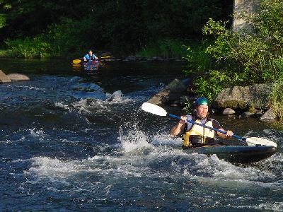
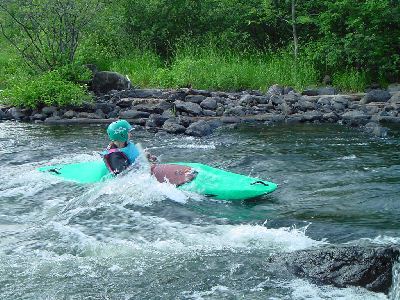
This is a great training river. It starts out very easy then gets a little harder as you head downstream. The first mile starts out with quickwater that gradually turns into class I. This class I rapid is great for learning ferrying and eddying manuevers. At the railroad bridge, run the middle channel between the abutements. Run the center of the next drop. There is a lot of pinning potential in the rocks downstream of this drop in low water. This drop is class II and II+ above 1000 cfs. The left side of this drop has a hole. You can eddy out just downstream to the left of the hole so you can get the best approach to a nice surfing wave adjacent to it. At the next railroad bridge look out for a pilling sticking out vertically just right of center of the center channel. At 700-800 cfs this pilling is just under the surface and hard to recognize. At lower levels it is obvious and easy to avoid. Just downstream of the bridge is a wide easy surfing wave just before the river splits around a small island with a town park on it. Just past a street bridge downstream, there is a nice wide surfing wave extending out from river right. This one does not have an eddy to serve it so you will need to catch it on the fly. Take out on either side of the river after the next bridge and past the line of restored train cabooses. River Left is parking for the Winnipeasukee River Trail; River Right has a picnic are and bathrooms in Riverfront Park.
### Technical info
```
Put in elevation........470'Take out elevation......418'Total drop..............52'Average drop/mile.......25'Distance................2.1 milesRiver width average.....60'River geology...........Small schist bouldersRiver water quality.....Good in spring fair latter in Summer, clarity fair to good.Scenery.................Fair, 1st mile forested, last urban with apartments right up to the rivers edge, some old dam remains with log cribbing and some rebarr.Wildlife................Merganzers, Blue herons.
```
The upper section (class I-II) starts out in Tilton just south of the Kentucky Fried Chicken on NH 140. This section is suitable for novice boaters. It is approximately 2 miles long and should take about 45 minutes to an hour to complete. More information including description and directions here: Upper Winni webpage
Please note these are not official trips they are only notification of paddlers meeting locations and times in order to make paddlers aware of a meeting and launch point of “common adventurers”. Each paddler is responsible for his or herself being properly equipped for the conditions to be encountered that day. That means PFD’s, wet suits, dry suits, gloves, helmets, booties, etc. Furthermore, each individual is responsible for their own safety, you should have the skills and physical conditioning to be able to perform or assist in self rescue and not put your fellow paddler in danger by being irresponsible.
Winni Proposal We need backing on this from the paddling community. We are looking for summertime releases on this river and this event will help publicize our request. Make sure you tell the press you are in favor of summer time recreational releases on the Winnipesaukee River
This is a prime opportunity to get our voices heard on this matter. We will get front page news coverage on this, better than sending hundreds of letters to the legislators.
Please show up and support us on this, a huge turn out will be bigger news.
### Put in
Directions from the south: Interstate 93 north to exit 20 (Tilton, Laconia) Approximately 1 hour from the Mass NH border. Go straight through the lights at the end of the exit ramp past McDonalds, Burger King, Kentuckey Fried Chicken. Immediately following the J.J. Niesen bread factory on your right, you will pass over the bridge then continue on 100 yards then take a right. Another 50 yards to the put in on the right. Our traditional put in by the bridge is no longer available, it is now posted and roped off. The new put in is on a cove extending out from the main flow of the river and is owned by the state of NH. It tends to get 'weady' in late summer and is usually frozen in early spring.
### Take out
Drive back past McDonalds and take a left at the light.
Approximately 1.5 miles at the light take a left on route 132.
75 yards take a right just past the line of train cabosses. The take out is just past the railroad tracks.
Rapids in this Run (1)
Playspots (3)
Hazards & Portages (2)
Caution: The following locations may require scouting or portaging. Always check current conditions.
Difficulty
Class I-II
Length
2.0 mi
Gradient
25 ft/mi
max 35
Rapids
1
2 Hazards
Access Points
Difficulty Classes
I Easy
II Novice
III Intermediate
IV Advanced
V Expert/Extreme
VI Unrunnable
Current Conditions
5-Day Forecast
Whitewater data from
American Whitewater
American Whitewater