2. Below Salt Springs Reservoir to Tiger Creek Afterbay
Linked via: Proximity 85% confidence Synced 6mo ago
Gauge Conditions
Runnable: ? – ? CFS
Approximate reading: This gauge is 60.4 miles away on Mokelumne. Use as a general reference only.
Data from American Whitewater & USGS
Run Map
Run Time Estimate
Select put-in and take-out to estimate time.
Unlock Advanced Trip Planning
See wind-adjusted speed maps, forecast planning, and detailed time estimates.
Sign in to generate an AI timing estimate for this run.
Whitewater timing varies with scouting, portages, and group pace. Use as a planning baseline.
Description
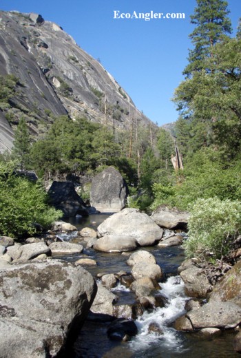
The Mokelumne from Salt Springs dam to Tiger Creek powerhouse is a very scenic section of river that is slowly getting greater recognition with scheduled releases and dependable flow information. The miles from Devil's Nose to Tiger Creek Powerhouse are compared to the most scenic runs in California.
From the dam past Calaveras Dome, the river is very steep and congested as it drops through a terminal morraine. Expect difficulty to be class 5 to class 6. We have no information on boaters paddling in this section or any specific details. From the campgrounds to the Bear River confluence there are a number of class 3 and 4 rapids and possibly a borderline class 5 rapid. From Bear River down to Devil's Nose, the run is mostly class 2 and 3 with a few class 4 rapids. Starting around Devils Nose the last few miles to the Tiger Creek powerhouse contain many class 5 rapids. Many of the rapids are long and will require scouting. Mokelumne Falls is a serious drop near the end with a committing rapid immediately upstream. The very last obstacle is a gauging weir that is an easy portage.
Scheduled boating releases occur on weekends in May of most years.
The recreational release flows on the Moke are a minimum; water year type and accretion from Cole Creek, the Bear River, and Tiger Creek proper can cause the flow observed on the North Fork Mokelumne to be greater than that number. Flows will be closer to the 700cfs or 900cfs release volume in dry years or particularly cold Springs. Please make sure you check recent flows before committing to a run!
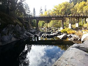
Getting There: The take out at Tiger Creek Powerhouse is about 20 miles or 30 minutes drive up Highway 88 from Jackson. Coming from Sacramento, drive about an hour up highway 16 to Highway 49 to Jackson. Take Highway 12 out of Lodi, or Highway 88 out of Stockton with similar distances and driving times. Turn down Tiger Creek Road to the powerhouse. The drive between the take out and put in is about 21 miles on Tiger Creek road, but will take about an hour. Alternatively you can drive back up to Highway 88, east to Ellis Road, then down Ellis Road to Tiger Creek Road. Ellis road is not plowed in winter.
Put In: Boaters will normally launch at a developed put in just upstream of Mokelumne Campground. Boaters can launch even further upstream since the road follows the river in this area. Near Calaveras dome the gradient is steep and very bouldery with rapids of class 5 or harder difficulty. Inspect the river carefully if you choose to launch higher than the normal put in.
Take Out: PG&E asks that boaters take out upstream of the powerhouse, on river right at a picnic area. There should be a sign facing upstream warning boaters to take out. From the picnic area it is a short level walk past the powerhouse, across the creek to the parking area. Park in designated recreation spots near the powerhouse.
Other information sources:
NF Mokelume (Devil's nose, IV-V) Blog by CA49rivers
Ca-Creeks NF Moke description
A Wet State, trip report
John Yost Trip Report part 1 in Ledger Dispatch
John Yost Trip Report part 2 in Ledger Dispatch
Cassady & Calhoun, Holbek & Stanley, Martin
Foothill Conservancy
Ecoangler.com
El Dorado Nat. Forest
FERC information:
The entire upper Mokelumne Watershed PG&E hydroelectric system is under a single FERC license, number P-137 A new license was issued on October 11, 2001 and will expire in 30 years from that date.
Text of whitewater boating monitoring plan.
Hazards & Portages (2)
Caution: The following locations may require scouting or portaging. Always check current conditions.
Difficulty
Class III-V
Length
14.6 mi
Gradient
60 ft/mi
max 110
Rapids
0
2 Hazards
Access Points
Shuttle Info
The map displayed below directs people back up to Highway 88 which is at least paved. Expect driving time to be an hour or more.
Alternatively take Tiger Creek Road to Salt Springs Road which parallels the river. Driving time will still be about an hour, but the actual distance is shorter. See this goople map of [Tiger Creek Powerhouse to Mokelumne River Campground](http://goo.gl/maps/YNTe).
Check with [El Dorado Nat. Forest](http://www.fs.fed.us/r5/eldorado/), Amador District for any road closures in the Salt Springs area.
Difficulty Classes
I Easy
II Novice
III Intermediate
IV Advanced
V Expert/Extreme
VI Unrunnable
Current Conditions
5-Day Forecast
Whitewater data from
American Whitewater
American Whitewater