2- Blyth Shoals - Hwy 11 to Talley Bridge
Linked via: Nhdplus discovery 90% confidence Synced 6mo ago
Gauge Conditions
Runnable: 50.0 – 1,000.0 CFS
Wide range of boatable flows. Basically a wet seal launch at lower flows. Big Class V with monster holes at high flows.
Data from American Whitewater & USGS
Run Map
Run Time Estimate
Select put-in and take-out to estimate time.
Unlock Advanced Trip Planning
See wind-adjusted speed maps, forecast planning, and detailed time estimates.
Sign in to generate an AI timing estimate for this run.
Whitewater timing varies with scouting, portages, and group pace. Use as a planning baseline.
Description
Puttin: The puttin is a pullout on highway 11 is roughly about .7 of a mile upstream from where the river takes a sharp turn away from highway 11.
Takeout: Just follow Blythe Shoals Rd. down to Talley Bridge. Please try to be as low profile and keep as close to the bridge as possible while taking out.
The Landowners: Please respect the landowners and the NO TRESPASSING signs. I have heard of a landowner here to escort people trying to fish on his property out with a shotgun in hand. Also if something occurs where you must get out of the boat try to stay out of sight.
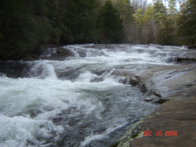
The Blyth Shoals section of the South Saluda is a short, extremely steep, micro gorge. The South Saluda River makes a 90-degree turn in the town of Blyth Shoals and plunges over a multi drop waterfall of the same name. This would be a great roadside whitewater run with good water after local rains but most of the river is HEAVILY posted with no trespassing signs. You can not get out to scout the big drop. The only way to scout is to do so while running shuttle. After the big rapid the river pools and then squeezes into a tight boulder filled drop above Talley Bridge.
At 400 cfs the big drop at Blyth Shoals becomes a class V monster rapid that could easily be mistaken for a big drop on the Green Narrows.
Blyth Shoals has been run at a variety of levels by boaters with expert skills. At low flows intermediate paddlers have run these rapids upright.
Waterfalls (1)
Playspots (1)
Hazards & Portages (1)
Caution: The following locations may require scouting or portaging. Always check current conditions.
Difficulty
Class III-IV(V)
Length
1.3 mi
Gradient
55 ft/mi
max 230
Rapids
0
1 Hazard
Access Points
Difficulty Classes
I Easy
II Novice
III Intermediate
IV Advanced
V Expert/Extreme
VI Unrunnable
Current Conditions
5-Day Forecast
Whitewater data from
American Whitewater
American Whitewater