2. Carmen Reservoir to Trail Bridge Reservoir
Linked via: Proximity 99% confidence Synced 6mo ago
Gauge Conditions
Runnable: ? – ? CFS
Approximate reading: This gauge is 1.6 miles away on McKenzie. Use as a general reference only.
Data from American Whitewater & USGS
Run Map
Run Time Estimate
Select put-in and take-out to estimate time.
Unlock Advanced Trip Planning
See wind-adjusted speed maps, forecast planning, and detailed time estimates.
Sign in to generate an AI timing estimate for this run.
Whitewater timing varies with scouting, portages, and group pace. Use as a planning baseline.
Description
Upper Carmen Bypass Reach
The Whitewater Boating Feasibility Report found that the 2.5-mile Upper Carmen Bypass Reach, with a gradient of 50' per mile, could provide Class II–III boating opportunities with adequate flow, but such flows are unlikely to attract whitewater boaters. While the segment travels through a scenic forested environment, it lacks interesting channel features and whitewater rapids. The reach has extremely porous volcanic terrain and complex hydrology.
Lower Carmen Bypass Reach
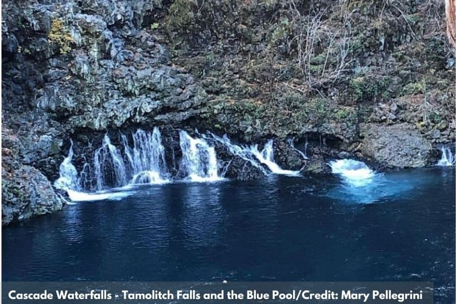
The lower Carmen Bypass Reach is about 2.4 miles long. The gradient in the first mile of the reach exceeds 200 ft/mile; below the gorge, the gradient decreases to approximately 60 ft/mile. Below 45-foot Tamolitch Falls, Blue Pool collects aquifer discharge near the base of the falls and other nearby springs. This produces base flows from 140 to 160 cfs in the gorge (with slightly higher flows downstream of Kink Creek). Spills over the Carmen Diversion Dam and basin inputs during rain or snowmelt events increase these flows—sometimes by several hundred cfs—although several factors related to the porous aquifer complicate the timing and amount of flows. Blue Pool is the put-in for the lower Carmen Bypass Reach boating run, and is accessible by hiking at least 2 miles on the McKenzie River Trail. An alternative is to hike to Blue Pool down a steep informal trail from an old road spur off Highway 126.
Documented use of this river segment dates back to at least 1996 when the reach provides kayaking opportunities during occasional higher flows. A narrow channel and multiple logs and log jams probably preclude rafting use. The reach is generally class IV with technical rapids requiring scouting and portaging.
Boaters who participated in the Whitewater Boating Feasibility rated hypothetical flows for boating to be between 100 and 2,000 cfs; flows below about 300 cfs are predicted to be unboatable, but from 300 to 500 cfs, small flow increases are predicted to substantially improve quality. Responses to the “specified flow” questions suggest: (1) 330 cfs is needed to provide an acceptable technical trip, (2) the transition between technical and standard trips is 450 to 500 cfs, (3) standard opportunities are optimal from 500 to 750 cfs, (4) the transition between standard and big water trips is about 700 to 800 cfs, and (5) big water opportunities are optimal above 800 cfs (but study flows were not high enough for precise estimates for this opportunity). When asked to specify a single preferred flow, most preferred flows between 450 and 600 cfs.
Existing base flows of approximately 150 cfs are not boatable, but spills from Carmen Diversion Dam or accretion during rain or snowmelt events may provide technical and standard trips about 35 days in an average year based on the historical record (assuming current diversion practices). Boaters lack information on flows because there is no gage on the reach. The Whitewater Boating Feasibility Study concluded that boating opportunities could be improved if flow data or flow predictions became publicly available. American Whitewater did not requested scheduled releases for this run, requested this information that was included as a condition of the Recreation and Aesthetics Management Plan for the hydropower license.
Waterfalls (1)
Difficulty
Class III-IV
Length
5.5 mi
Rapids
0
Access Points
Difficulty Classes
I Easy
II Novice
III Intermediate
IV Advanced
V Expert/Extreme
VI Unrunnable
Current Conditions
5-Day Forecast
Whitewater data from
American Whitewater
American Whitewater