2. Crooked R. Ranch to Billy Chinook Reservoir
Linked via: Proximity 79% confidence Synced 6mo ago
Gauge Conditions
Runnable: 1,100.0 – 5,000.0 CFS
Data from American Whitewater & USGS
Run Map
Run Time Estimate
Select put-in and take-out to estimate time.
Unlock Advanced Trip Planning
See wind-adjusted speed maps, forecast planning, and detailed time estimates.
Sign in to generate an AI timing estimate for this run.
Whitewater timing varies with scouting, portages, and group pace. Use as a planning baseline.
Description
In high water this reach is often run as a continuation of the Upper Crooked, particularly by rafts that don't have a practical means of taking out at Crooked River Ranch.
At base flow, this reach can be run by itself as springs provide sufficient inflow through the summer for kayakers and packrafters. With some boney rapids, the one mile hike in, and an option for a two mile hike out this makes a great packraft day trip. The best gauge to refer to is Crooked River at Osborne Canyon, or COBO. This will give you an idea of how much flow you will start at China Dam with. Springs will add ~1000cfs throughout the run. Anything over 100 cfs is runnable, though over 150 is even better. Rafts would not have such a good time at summer flows. The primary issue for either rafts, or kayaks doing this section is access which is less than ideal on both ends of the run.
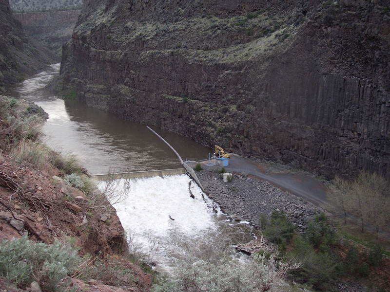
The dam at Opal Springs generates hydropower and is a 4.3 MW project licensed by the DeschutesValley Water District as FERC Project 5891. The project was licensed in 1982, constructed in 1985, andwill be eligible for relicensing in 2032 when the current license expires.
Logistics
To reach the put-in from Terrebone, head north on Highway 97 but before you cross the river headwest at Highway 97 mile 115.3 on Lower Bridge Road towards Crooked River Ranch. Follow Lower Bridge Rd. 2.1 miles and turn right on NW 43rd St. Continue 1.8 miles to the T junction and turn left onNW Powey Ave. Continue on this road, which becomes Chinook Dr., for 3.2 miles as it drops down tothe golf course and turn right on Clubhouse Rd. Drive in 0.4 mile heading right at the church and pastthe cabins to parking along a fence a short distance from the gorge rim. From this parking spot, youcan hike the old Hollywood Road which is the gate to the east of where you park. The road is no longeraccessible be vehicles as several boulders have come down from the cliffs above and vegetation hasgrown in making it nothing more than a trail. It's about a mile down this old road to the river which provides access near China Dam. Due to the steep climb, the option of this put-in as a practicalalternative is only feasible for kayaks, IK's, and packrafts.
A hiking trail leaves the river at mile 5.2 and climbs steeply, then traverses a flat bench to the Otter Bench Trailhead. The two mile walk is probably too far for most kayakers, but with packrafts is peasant and makes for an simple shuttle and no lake paddling.
At the take-out you have to paddle out on Billy Chinook Reservoir. Some rafts have arrangedaccess at Opal Springs (at river mile 7.2) thus avoiding the long paddle on the reservoir but the word isnot to do the calling yourself as too many people phoning in has resulted in nobody having access.Arrangements need to be made through the paddling community with someone who has the necessarycontacts. For the rest of us you'll just need to be prepared to paddle out on the reservoir which beginsnear river mile 6. The take-out is located where a bridge crosses the Crooked River Arm of the reservoirat river mile 3.2 (of what was the historic river bed of the Crooked).
Hazards & Portages (1)
Caution: The following locations may require scouting or portaging. Always check current conditions.
Difficulty
Class III+(IV)
Length
10.0 mi
Gradient
35 ft/mi
Rapids
0
1 Portage
Access Points
Difficulty Classes
I Easy
II Novice
III Intermediate
IV Advanced
V Expert/Extreme
VI Unrunnable
Current Conditions
5-Day Forecast
Whitewater data from
American Whitewater
American Whitewater