2. Eden Mill Dam to Rocks State Park
Linked via: Nhdplus discovery 90% confidence Synced 6mo ago
Gauge Conditions
Data from American Whitewater & USGS
Run Map
Run Time Estimate
Select put-in and take-out to estimate time.
Unlock Advanced Trip Planning
See wind-adjusted speed maps, forecast planning, and detailed time estimates.
Sign in to generate an AI timing estimate for this run.
Whitewater timing varies with scouting, portages, and group pace. Use as a planning baseline.
Description
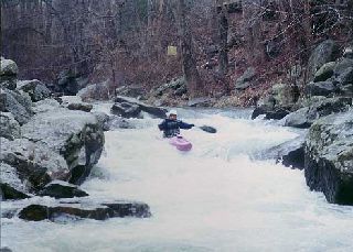
There is a two part Class III rapid called 'Deer Creek Rapids @ Rocks' upstream of the gauge at the end of the run. The run upstream of 'Deer Creek Rapids @ Rocks' is rather tame. Most people just run the 'Deer Creek Rapids @ Rocks' putting in just above it along MD 24 and take out just below the second drop (there's parking both above and below the drop). Of course, beginners running from Eden Mills who might not want to run this rapid, can easily take out above it.
At the very top of the first drop, there is a little wave that will push your bow to the left, if you let it. Don't let it, because the left channel is especially trashy towards the bottom. Try to punch this little wave and stay more right of center in the beginning part of the rapid.
The second drop is deceptive, because it looks like a clean chute (which it mostly is). But just to the left of the chute, there is a rock that presents a pinning/foot entrapment risk. General public swimmers have been known to play in the chute as a slide and every now and then someone hits it wrong and gets their foot entrapped by this rock requiring rescue or recovery. Whitewater paddlers can avoid this by setting a right angle at the lip of the chute. Of course, it would be wise to scout both drops before running them.
See Gertler, Ed; _Maryland and Delaware Canoe Trails_.
Lat/longitude coords are VERY approximate, from TopoZone.
Ed Evangelidi testifies:
The Class 3 rapids at Rocks may be negotiated down below 150 CFS, as it is quite constricted.
Playspots (1)
Hazards & Portages (1)
Caution: The following locations may require scouting or portaging. Always check current conditions.
Difficulty
Class I-II(III)
Length
5.2 mi
Rapids
0
1 Hazard
Access Points
Difficulty Classes
I Easy
II Novice
III Intermediate
IV Advanced
V Expert/Extreme
VI Unrunnable
Current Conditions
5-Day Forecast
Whitewater data from
American Whitewater
American Whitewater