2. GW Canal Loop or Violettes Lock to Pennyfield Lock
Linked via: Nhdplus created 95% confidence Synced 6mo ago
Gauge Conditions
Runnable: 2.0 – 6.8 FT
Data from American Whitewater & USGS
Run Map
Run Time Estimate
Select put-in and take-out to estimate time.
Unlock Advanced Trip Planning
See wind-adjusted speed maps, forecast planning, and detailed time estimates.
Sign in to generate an AI timing estimate for this run.
Whitewater timing varies with scouting, portages, and group pace. Use as a planning baseline.
Description
\[ It has come to our recent (2025) attention that the take-out trail for the C&O Canal paddle back up to Violette's Lock has become very muddy/slippery and difficult for older or disabled paddlers to navigate without slipping and falling or requiring help. If there are concerns, consider running a shuttle down to Pennyfield Lock and taking out there.\]
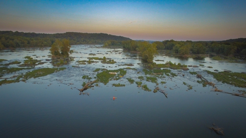
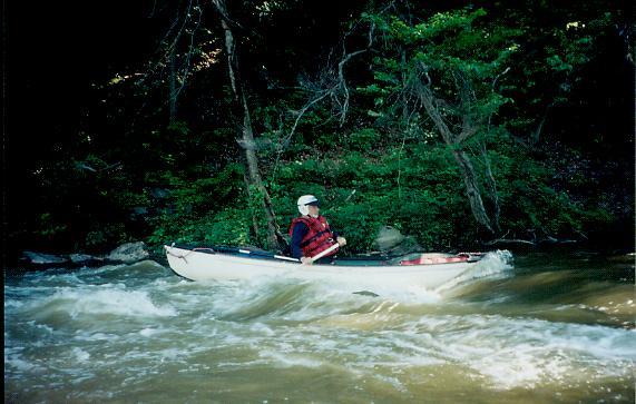
The channels between the islands on the Virginia side of the Potomac at the mile long stretch known as the Seneca Breaks provide an excellent run for paddlers who are working on their skills. Rock walls from George Washington's Patowmack Canal, constructed in the 1790s to carry boats around the Breaks, are still visible in places, giving this run its nickname of the 'GW Canal'. The rapids are Class II in nature and are appropriate for practiced novice and higher skilled boaters. The river seems to pick up a lot of strainers here, so be on the lookout for ever changing obstructions. The river can also be run down the main channel but this isn't the traditional run.
If the C & O Canal on the Maryland side of the river contains water, or if levels allow an attain up the main channel, this run has the additional advantage of being able to be run as a loop. If the C&O Canal is dewatered (which it is usually in the winter) a shuttle can be set downstream at Pennyfield Lock. The canal's towpath can be used to get those shuttling on foot or bike back upstream.
Accessed from Riley's Lock or Violettes Lock along the C & O Canal (see directions below). At Riley's Lock, put in at either the floating boat dock or the boat ramp and paddle down Seneca Creek to the Potomac. At Violettes, walk across the canal bridge and follow a faint trail to the right and down to the river bank at the top of a canal feeder channel, put in and paddle up to the main channel. In either case, paddle across the river, which is very wide here, above the old canal dam. Enter a river right channel on the Virginia shore just above the dam and you are on the commonly run portion of the river. Parts of this intimate channel are formed by the old George Washington canal, a failed Virginia-side canal project that has now been retaken by the river here.
Once in the channel, the current picks up. Strainers are a constant problem, so please be aware and make sure you have the skill to avoid them. The first rapid is Slalom Rapid, an open rock garden good for figure 8 eddy turn and attaining practice. The next rapid is Surfer's Ledge, a friendly hydraulic at many levels. Staying to the right below Surfer's, the channel next bends forty five degrees left to arrive at the rocky/shallow Diagonal Rapid, with the line changing depending on where debris is currently piled. Below Diagonal there are two channels separated by an island: the Jacuzzi channel (right) and the Kingfisher (center-left) channel, with a variety of ledges, one of which is known as the 'attainment' ledge, the rest unnamed as far as is known. (Note: there is also a far left channel that can be used to return to the main river, but it can be blocked.)
After the left and right channels join below the island there is a short flatwater strech followed by 30 Eddy Rapid, the final rapid in this stretch.
Immediately after 30 Eddy Rapid, turn left and up/out into the main flow of the Potomac. A few small rapids remain in the main stem, but ferry left after them to the Maryland side with the friendly assist of the main channel current.
There are three options to return here. 1 Attain back up the main channel, with good levels around 3.1 to 3.6 on the Little Falls gauge. Just below the rubble dam on the Maryland side there is a gap between two small islands that can be attained. This leads to a short trail to the Violettes Lock parking lot. 2 Back up the Canal- Another loop trip option, if there is water in the C&O Canal, is to take out at the big sycamore witha large yellow swuare on the Maryland shore just below the final rapids of Seneca Breaks. There a short trail leads to the canal, then one can paddle back up the canal to Violettes Lock parking lot, spotting turtle after turtle in good weather. Total run for either of these: 3.4 miles. For those who parked at Riley's Lock, carry around the lock to the put in just upstream and paddle the half mile upriver to Seneca Creek, then up the creek to the parking lot, adding an extra mile to the loop.
3 Or paddle downriver to Pennyfield Lock, total run 3.3 miles, or to Swain's Lock, total run 6.3 miles. Several islands appear downstream, it is important to stay on the Maryland side of these, as passing to the right of the miles long Harris Island will deliver you downstream of both Pennyfield and Swain's Locks.
Look for the entrance to Muddy Branch to the Pennyfield take out (There was a sign here, but as of 2025, it's gone -- a replacement is in the works). It's upstream from the lock house a couple hundred yards. On your way downstream, hug the MD side of the river to find the channel. Once in the channel, paddle upstream 0.2 miles or so to the tunnel under the C&O canal and the boat ramp immediately afterward.
When setting shuttle at Pennyfield Lock, the boat ramp is at the right end of the parking lot.
Directions: All of the locks mentioned are off of River Road (Route 190) in Montgomery County, Maryland about 6-10 miles north of Potomac, MD. From Potomac, travel north on River Road to a left turn onto Pennyfield Lock. For Violettes Lock, continue on River Rd 2.5 miles to another left. The Violettes Lock turn is on a curve and is easy to miss. For Riley's Lock continue past the turn for Violettes Lock to the stop sign at the intersection of Route 112, take a left to stay on River Rd, then take a left turn at the bottom of the hill, just before the bridge over Seneca Creek. Park in the first large parking lot on the left.
Rapids in this Run (9)
Difficulty
Class II
Length
3.6 mi
Rapids
9
Access Points
Difficulty Classes
I Easy
II Novice
III Intermediate
IV Advanced
V Expert/Extreme
VI Unrunnable
Current Conditions
5-Day Forecast
Whitewater data from
American Whitewater
American Whitewater