2. Highway 64 to Augerhole Road
Linked via: Proximity 96% confidence Synced 6mo ago
Gauge Conditions
Runnable: ? – ? CFS
Approximate reading: This gauge is 6.2 miles away on Toxaway River. Use as a general reference only.
Data from American Whitewater & USGS
Run Map
Description
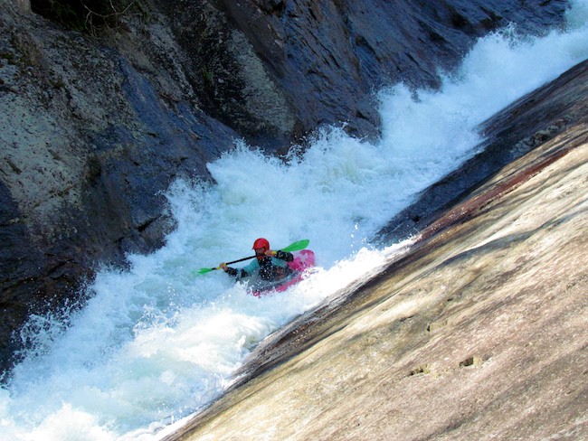
This run is one of the most serious undertakings available in the southeast. It should only be attempted by those who are skilled enough to do it. The upper mile or so is fun and reasonable class IV+, once you get to Minigizer the run stays V to V+ all the way till the end. Minigizer, Energizer, Feeding Trough, Landbridge, and Wintergreen Falls are all on the large end of the navigability scale. Flipping over would be very bad and these rapids tend to dish out the less expected of situations.
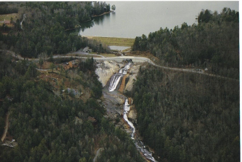
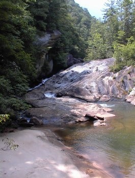
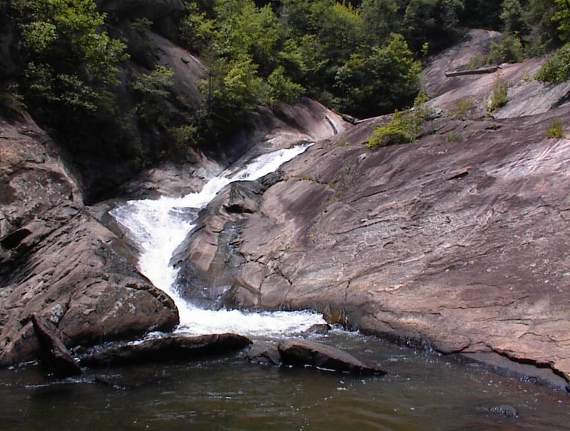
The run starts off below the main drop of Toxaway Falls. The middle two drops are seldom run but the bottom two are super fun. Slide in on river left for a very long and fun slide of about 200 yards in length. Great fun!
Paddle around the corner through some flats and then the next rapid is a low quality boulder pile called First Mank.
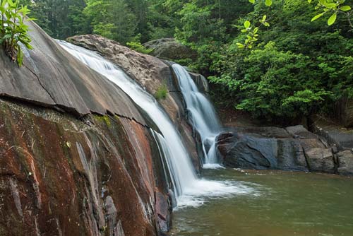
Eddy out at the next horizon line for Twin Falls, a 15 footer split by a rock. The only sensible line is on the right trying to stay center. Make sure to hit a big boof with your weight forward. A rock shelf extends out from river right making the landing narrow.
Immediately below here the river begins its ride down a long series of class IV to IV+ bedrock slides called Space Mountain. The first set is more abrubt and ledgy, with the second set being bigger, faster and lower angle class V. After these two great sets, there is a short calm followed by a long low angle slide against the bank on the left.
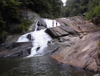
After a short flat stretch the river picks back up with a 3 foot ledge followed by a fun little class IV with a sticky hole below. Right below this the creek goes down a fun slide that falls into a big fold on the left. This one is good fun, but sometimes there is a log in the upper left hand crook of the fold, so drive out to the right a little to clear this possible situation.
Following the fold rapid is a nice little sluice against the left bank and then you reach the last rapid above the hard section. This rapid is a fun and narrow slide that drops around 20 feet. The hole at the bottom is very powerful and its best to melt it and come up stroking. Boaters have swam out of here before.
Right below this sticky hole is Minigizer, the first of many gigantic rapids. There are two options here. One is to get out of the boat and launch off the misplaced boulder that creates a bridge of sorts across the river. For most this is the way to go. However recently boaters have been doing 'the gullotine' move by starting at the top and ducking the land bridge. Know full well the consequences of failing to duck here....This rapid drops around 40 feet.
Below Minigizer is the portage above Energizer, although one of the drops can be run but the risk for a blown move it pretty high. To portage this section and reach Energizer either get river left and hike down the slick rocks or ferry across the pool and climb over some rocks. Both routes will put you just above Energizer.
Next is the seal launch portage, which necessitates a fun and reasonable seal launch down the bedrock on the left side of the river. I beleive Dane Jackson ran this rapid back in the day but doesn't sound like many have done it since.
Below here is a straightaway of flatwater with granitic rock wall on the right. At the end of this straightaway is the top of Big Mank. Get right as you can and fight the inevitable slide into a midstream ridge of rock. After gaining control be ready for the launch over a big 5 foot pourover that quickly sends you towards a very ugly pin rock with a big boil on it. The usual line is to the left of this boulder with speed and strong intent. The bedrock finish to this series is manky and unpleasant. The whole rapid can be walked easily on the right.
Right after Big Mank is Feeding Trough, a particularly tricky groove rapid with no room to roll in the event of flipping. Don't mess up. The portage is easy and best done on the ridge of rock in the center of the river.
Right below feeding trough is a 3 foot slide and then a 20ft ledge.
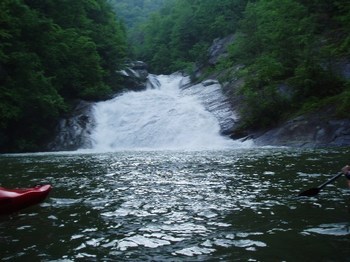
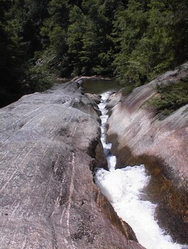
After this steep angle slide comes 40/40, one of the stoutest waterfalls anywhere and certainly the gnarliest that gets run on the river. It is ran all the way on the right but for most it is a portage on the left.
Right after 40/40 the river turns left. Get out here and start portaging up the mountain side. Land Bridge is around the corner and the upper half is unrunnable. There should be some flagging tape to follow. This will put you on top of Land Bridge.
This is the sketchiest portage on the run so take your time. To run it seal launch off of the Land Bridge.
Two ledges below Landbridge is Wintergreen Falls, the giant hair raising finale to the biggest drop run in the east coast. Wintergreen Falls drops 30 feet of steep blazing bedrock onto a dome that then races at breakneck speed off another 40 foot slide. The line is obvious yet complications occur often on the second tier where the bedrock is chaotic. The portage is on the right and aint so bad. From here the paddle out is under 2 miles of boulder piles. Watch out for a bad rapid in the middle that sneaks up on you. It has a bad sieve and hole and there are often trees in this area.
When you reach a gravel road that crosses the river and Bearwallow Creek comes in on the right, get out on the left and get your gear in order for the 3.5 mile hike out to Frozen Creek Access parking lot unless you have a car at Turkeypen Gap.
You can also continue the paddle on down to Lake Jocasse where there are two more significant waterfalls.
Chris Young says:
'Hey Bradley, I noticed on the awa website it rated the toxaway gorge, ie below the falls like in southern fried, class IV-V. Having done it once about ten years ago and then again about two weeks ago I would suggest you change the rating to V+. It is more commiting than the raven fork in a number of ways and with people discussing it recently, I would hate to see someone get in way over there heads. Just a suggestion.' Dec. 30, 2002.
More from Chris:
'The times it has been run recently, which is two of which I was on one trip, we took of at the road and the hike out is around 3.5 miles. Years ago I paddled to the lake and there is a guy who will pick you up for $$$. The toxaway has several sketchy portages and a few rapids that would be hard to portage, most notably wintergreen falls. It is a drop/slide that would make stairway on bear or mike tyson on raven fork seem a little small but the portage looks worse. People will probably get a better idea of what it is like on an upcoming issue of LVM, there are several drops for sure that were run which weren't on Southern Fried Creeking.'
From Leland Davis:
'Using my topo software, I get that the run is 3.69 miles from the baseof the falls to Auger Hole Road. Drops by mile are 291, 596, 245, and128 feet of drop in the last .69 miles. The steepest mile peaks out at632 feet. Unlike past parties, Dinver and I easily portaged wintergreenfalls on river right. No big deal. It's much easier than a lot of theother portages - of which there are plenty.'
Toxaway was run a number of times over the winter of 2002-2003. The parties were using the river left trail at the lake as a takeout. This involves a 4 mile carry out, with a major elevation gain. Eat your wheaties.
Be aware that the land on river right at the put-in is private and VERY exclusive. Its been advised to hike in on the steeper river left side, and to avoid walking thru the back yards of the condos.
Rapids in this Run (6)
Waterfalls (11)

Hazards & Portages (12)
Caution: The following locations may require scouting or portaging. Always check current conditions.
Difficulty
Class V+
Length
6.1 mi
Gradient
250 ft/mi
max 630
Rapids
6
12 Hazards
Access Points
Difficulty Classes
I Easy
II Novice
III Intermediate
IV Advanced
V Expert/Extreme
VI Unrunnable
Current Conditions
5-Day Forecast
Whitewater data from
American Whitewater
American Whitewater