2. Hoh Rainforest Campground to Hwy 101 at Oxbow
Linked via: Proximity 99% confidence Synced 6mo ago
Gauge Conditions
Runnable: 1,000.0 – 6,000.0 CFS
Data from American Whitewater & USGS
Run Map
Run Time Estimate
Select put-in and take-out to estimate time.
Unlock Advanced Trip Planning
See wind-adjusted speed maps, forecast planning, and detailed time estimates.
Sign in to generate an AI timing estimate for this run.
Whitewater timing varies with scouting, portages, and group pace. Use as a planning baseline.
Description
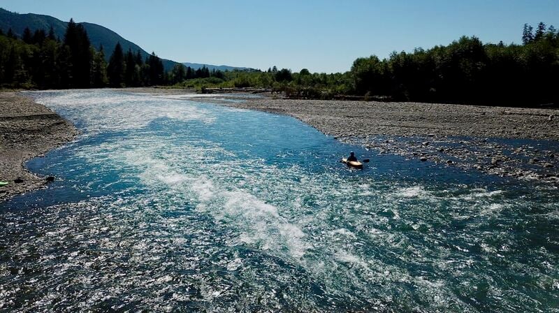
Although each coastal river is unique, the Hoh River has many of the characteristics of the west side rivers that also include the Queets, Quinault, and Bogachiel. The Hoh River is a large floodplain river with some powerful currents and impressive log jams that can create hazards for novice boaters. The river has been popular with steelhead fishermen. You can put-in at the campground within the Olympic National Park near the Hoh Ranger Station--this is the most popular site where tourists come to visit the Olympic Rainforest. While there are many places to experience the Pacific Temperate Rainforest, this is the place to go for the half hour look with a nice interpretive trail.
You can start your run from the campground but this is generally less popular. The hazard rating due to wood is slightly higher from the campground to the confluence with the South Fork near the park entrance station, a distance of approximately 6 miles. Once you pass the South Fork, the river becomes large enough that wood hazards become less of an issue although you still need to use extreme caution. Wood is the primary hazard to be prepared for along the length of this run and it's not a good place for novice paddlers without an experienced guide.
The run from the entrance station boat ramp to Morgan's Crossing is a popular 6 mile day trip and has one somewhat challenging section just above Coons Bar, which is located a couple miles upstream of Morgan's Crossing. The other popular trip is to start from Morgan's Crossing and continue down to the Oxbow Recreation Area, an 8.5 mile trip. The most challenging rapids of this section are created by the exposed bedrock at the Oxbow, but at moderate flows these are class II.
Paddlers can continue on downstream beyond the Highway 101 bridge, but these lower sections of the river are generally not considered a whitewater trip.
Access: The take-out is right off Highway 101 at mile 176.7 where you will find the turnfor the DNR's Hoh Oxbow Recreation Area. This site is on the upstream river right side of the Highway 101 Bridge, and campsites are provided along with river access. To reach the put-in go to Highway 101mile 178.6 and turn onto the Upper Hoh Road which parrallels the river. You will pass two DNR Campgrounds that provide potential access points: Willoughby (mile 3.6) and and Minnie Peterson (mile 4.7). The most popular access point on the run is located 7.3 miles up the road and known as Morgan's Crossing. In 12.5 miles you will reach the park entrance station and a nearby river access. If you continue upstream, it's 18.5 miles from Highway 101 to the Ranger Station which is the end of the road and the upper put-in near the campground.
for additional information see
- Korb, G. 1997. A paddlers guide to the Olympic Peninsula. third edition.
- \[Olympic National
Park website\]()
Rapids in this Run (2)
Difficulty
Class II
Length
21.0 mi
Gradient
24 ft/mi
Rapids
2
Access Points
Difficulty Classes
I Easy
II Novice
III Intermediate
IV Advanced
V Expert/Extreme
VI Unrunnable
Current Conditions
5-Day Forecast
Whitewater data from
American Whitewater
American Whitewater