2 - Mallardy Creek to Verlot (Middle)
Linked via: Proximity 94% confidence Synced 6mo ago
Gauge Conditions
Runnable: 5.1 – 8.0 FT
Data from American Whitewater & USGS
Run Map
Run Time Estimate
Select put-in and take-out to estimate time.
Unlock Advanced Trip Planning
See wind-adjusted speed maps, forecast planning, and detailed time estimates.
Sign in to generate an AI timing estimate for this run.
Whitewater timing varies with scouting, portages, and group pace. Use as a planning baseline.
Description
FUN FACT: Good class III run with camping and hiking nearby
SEASON: After some good winter rains and through the early summer (October through July). The run tends to be flashy in the range of levels of interest to boaters. Flow can change dramatically over the course of a day and levels that look good in the morning can be a totally different story by afternoon.
PUT-IN: Just upstream of Wiley Creek Campground (Highway Mile 15.1) at a pull-out where you can find good river access (there have been landslides recently here, so use caution using this spot). You can put in any place upstream to lengthen the run with more class II action. A good option is Boardman Creek (Highway Mile 16.8). Red Bridge campground is another possible access point.
TAKEOUT: Verlot Campground (Highway Mile 11.3) is one good access point. If you want to cut off some of the class II at the end you can also take out at the Mountain Loop Highway bridge (Highway Mile 12.0) across the Silliguamish just east of Verlot campground.
SHUTTLE: Follow Mountain Loop Highway as it parallels the river.
DESCRIPTION:
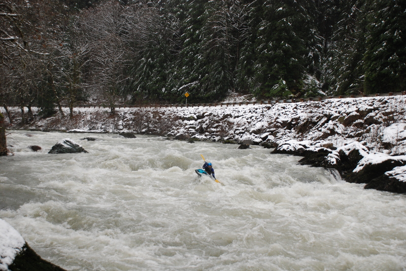
Known to locals as the 'Silly Stilly', this section is a good class III run with fairly continuous action and a lot of good spots to practice technique. It's a good run for those just making the jump to class III whitewater.
Depending on how far you go upstream, the run starts out with good class II whitewater. The rapids are not difficult but there is a lot of wood on this run and there are several points where solid boat handling skills are critical to stay out of trouble.
As you approach Wiley Creek (a small stream that empties into the river from river right) the pace begins to pick up a bit with some more challenging slalom style boulder gardens. The real class III action arrives with Wiley Creek Rapid. You can recognize the entrance by the distinct S bend which ends in a large pool up against the side of the road (this spot is easily recognized from the road at highway mile 14.6 and can be scouted on your way to the put-in).
The river picks up speed as it plunges through the boulder field and resistant bedrock of Wiley Creek Rapid. Although the rapid is generally considered a straight forward class III+, those looking for more of a challenge can create their own slalom course through the rapid to spice things up a bit (once you start climbing above 6' on the gauge this rapid does approach class IV as some more significant holes begin to form). You can find a user friendly playspot on river left at the end of the last drop. It's particularly good spot for those just building their confidence and trying out their first moves. A short distance downstream look for the tea colored water of Black Creek coming in from the left to signal the entrace of the next series of boulders and ledges at Black Creek Rapids.
After a couple more easier rapids the river approaches Gold Basin Campground, which is the site of a huge channel diversion project constructed in summer 2021 ( Everett Herald Article About The River Channel Diversion Project). The river now goes through a newly-created channel with cabled logs all along the right bank. Keep a careful look out for wood in this section, and keep away from the right bank. High water events have already begun to dislodge and move wood here so look out for wood here and downstream, especially after high water events.
With good water, the rest of the run consists of II & III rapids until you reach the Mountain Loop Highway bridge. About 1/4 upstream from the Mt. Loop bridge, there used to be a very large logjam, which washed out in 2011. There are still remnants of logs in the river here, so be aware. There is a steep class 3+ rapid just above this spot. At higher levels you may find a sneak line down the left of this rapid. You can identify the approach to this rapid when you see a few houses on river left. You will find a fun rapid at the Mt. Loop Highway Bridge but beware of the current pushing into the engineered log jam on river right on the upstream side of the bridge. After the bridge, the pace slows a bit, but there are still a couple good holes to surprise you. Watch for a few homes on river right and a narrow bridge across the river; the takeout at Verlot Campground is immediately downstream of this bridge.
for additional information see: Bennett, J. and T. Bennett. 1997. A guide to the whitewater rivers of Washington, second edition. Swiftwater Publishing. Portland, OR.
Rapids in this Run (2)
Difficulty
Class III+
Length
8.4 mi
Rapids
2
Access Points
Difficulty Classes
I Easy
II Novice
III Intermediate
IV Advanced
V Expert/Extreme
VI Unrunnable
Current Conditions
5-Day Forecast
Whitewater data from
American Whitewater
American Whitewater