2. Powerhouse to Fishing Access
Linked via: Proximity 96% confidence Synced 6mo ago
Gauge Conditions
Runnable: 350.0 – 3,000.0 CFS
Data from American Whitewater & USGS
Run Map
Run Time Estimate
Select put-in and take-out to estimate time.
Unlock Advanced Trip Planning
See wind-adjusted speed maps, forecast planning, and detailed time estimates.
Sign in to generate an AI timing estimate for this run.
Whitewater timing varies with scouting, portages, and group pace. Use as a planning baseline.
Description
While technical creek runs higher up in the basin sit waiting for the spring snow melt, the Sultan can be enjoyed through the winter. It is also an option at the end of snowmelt when hydropower operations keep flow in the river. The Sultan offers a more technical paddling experience for those who are looking for an alternative to another Sky trip.
Most trips start at the Powerhouse, but this run can be extended by two miles upstream making a great 4 mile run if the gage for the upper below the diversion dam is reading at least 300cfs. This is the Horseshoe Bend section easily reached by continuing up the Chaplain Lake Road and taking a hike. See shuttle details above. The Horseshoe Bend section puts in right below Marsh Creek Falls and features a beautiful short gorge with numerous Class 3 rapids.
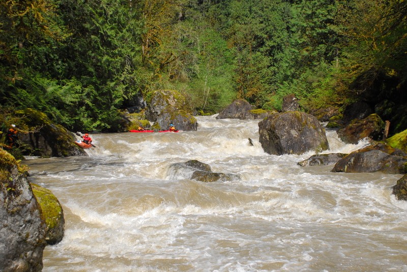
From the Powerhouse, the river tightens up a bit and plunges through a couple of technical class III+ drops. The most significant drop, Last Nasty, comes early in the run after passing through the first few drops. It's marked by a large eddy on river left, a rock wall on the left, and a large boulder near the center of the channel at a spot where the river takes a slight bend to the right.
Last Nasty can most easily be scouted or portaged on river right (although the eddy at the top of the drop on river left looks inviting scouting from this side is more challenging). The rapid itself requires a right, left, right set of moves with opportunities for skilled boaters to eddy out in between the sequence of drops and holes that need to be negotiated. It's worth a scout to pick your line and check for wood around blind corners. The crux move is the last ledge where you want to be far right almost up against the rock.
After Last Nasty the river continues with more technical class III+ drops similiar to the ones at the start of the run. There are a number of nice surfing waves and a couple of good pop up spots.
Once the river flattens out and homes start to appear you are nearing the end of the run. The takeout appears shortly on river left at an access maintained by Snohomish PUD.
Access: A few different options provide access to this river.
Powerhouse, river right: Turn north off Highway 2 onto Old Owen Road. This is the first major road west of the Highway 2 bridge across the Sultan River (an Arco gas station and the Red Apple Market mark this corner). Follow Old Owen Road 0.5 miles to a right hand turn onto Reiner Road. Follow this 3.2 miles to Lake Chaplain Road which turns off to the right. Pass through the gate (open 6 am to 6 pm daily, except Sundays when gate is closed at 3 pm) and follow the road 1.3 miles to a gravel pullout and registration kiosk on the right. Powerlines running down towards the river and some large transformers mark the general spot. Park at the pullout and hike your boat a short distance down the road to the bridge that crosses the river just upstream of the powerhouse. The Snohomish PUD (PUD) constructed a trail on river right, just upstream of the berm that spans the river for paddlers and fishermen to use.
Horseshoe Bend, river right: Continue past the pullout for the Powerhouse access and continue another 1.4 miles on Lake Chaplain Road until you see a gravel gated road on your right, this is the Diversion Dam Road kiosk. Hike down this road 1 mile and look for a vague trail down to the river on your right. The last part is a bit steep. If you can look over and see Marsh Creek Falls you just passed it.
The PUD prefers that paddlers access from river right, but if you find that gate closed for any reason there is also a viable route for access on river left. Just east of the town of Sultan (Highway 2 mile 23.1) turn north up Sultan Basin Road towards the Sultan Basin Recreation Area. Follow this road 2 miles and turn left on 116th St. SE. In 0.5 miles you will reach the gate to the powerhouse road (this gate is rarely closed) . Continue another 1.2 miles to a point where a couple of dirt roads turn off the main road and there's a sign for another gate. This gate closes daily so you will want to park outside the gate. The registration kiosk is located near the base of the communications tower. From here, it is a 0.6 mile hike to the bridge which you can cross to access the put-in on river right. There is an unlocked pedestrian gate that allows access across the bridge.
The standard take-out is the Trout Farm Road access maintained by Snohomish PUD. On the east side of the Highway 2 bridge across the Sultan take the first street into the town of Sultan. Take a left headed towards the direction of the river. When you get to First Street follow it north as it parallels the river. As you pass out of town, slightly less than a mile down First Street, Trout Farm Road turns off to the left. Follow this 1.3 miles to a well marked fishing access point on the Sultan River. Park in the gravel parking area near the road and walk down a dirt road to the river.
The run is a short distance in river miles, but not a quick bike shuttle due to the fact that access for the put-in and takeout are on opposite sides of the river and the only public bridge is where Highway 2 crosses the river.
Rapids in this Run (1)
Difficulty
Class III-IV+
Length
2.1 mi
Gradient
50 ft/mi
Rapids
1
Access Points
Difficulty Classes
I Easy
II Novice
III Intermediate
IV Advanced
V Expert/Extreme
VI Unrunnable
Current Conditions
5-Day Forecast
Whitewater data from
American Whitewater
American Whitewater