2. Quincy-La Porte Road to Milsap Bar Wild
Linked via: Proximity 88% confidence Synced 6mo ago
Gauge Conditions
Runnable: ? – ? CFS
Approximate reading: This gauge is 7.7 miles away on Feather. Use as a general reference only.
Data from American Whitewater & USGS
CDEC Flow Data California
Data from California Data Exchange Center (CDEC)
Run Map
Put-in
Take-out
Rapids/Hazards
Wild
Scenic
Recreational
Run Time Estimate
Select put-in and take-out to estimate time.
Unlock Advanced Trip Planning
See wind-adjusted speed maps, forecast planning, and detailed time estimates.
Sign in to generate an AI timing estimate for this run.
Whitewater timing varies with scouting, portages, and group pace. Use as a planning baseline.
Description
History:
The Devils Canyon run on the Middle Fork Feather is the undisputed king amongst moderate Class V California overnight self support classics.
The Middle Fork Feather was one of the original rivers designated under the Wild and Scenic Rivers Act of 1968.
In October of 1968, the Wild and Scenic Rivers Act pronounced, '*It is hereby declared to be the policy of the United States that certain selected rivers of the Nation which, with their immediate environments, possess outstandingly remarkable scenic, recreational, geologic, fish and wildlife, historic, cultural or other similar values, shall be preserved in free-flowing condition, and that they and their immediate environments shall be protected for the benefit and enjoyment of present and future generations. The Congress declares that the established national policy of dams and other construction at appropriate sections of the rivers of the United States needs to be complemented by a policy that would preserve other selected rivers or sections thereof in their free-flowing condition to protect the water quality of such rivers and to fulfill other vital national conservation purposes.'*
The entire Middle Fork downstream from the confluence of its tributary streams one kilometer south of Beckwourth is protected under the act, broken down as:
Wild — 32.9 miles; Scenic — 9.7 miles;
Recreational — 35.0 miles;
Total — 77.6 miles.
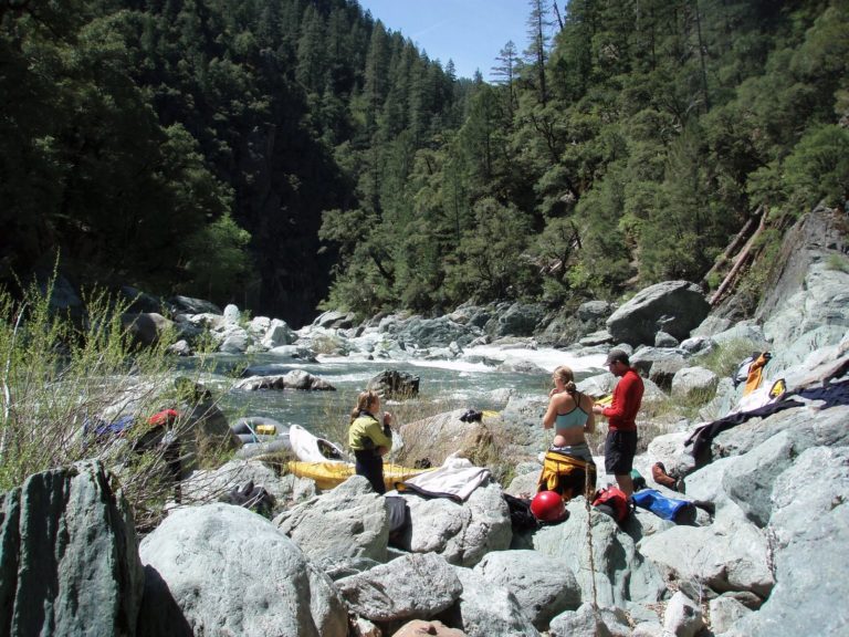
The Run: The run passes through three distinct canyons of very different geology, slowly increasing in both volume and difficulty. Most groups choose to do the run over three days, but two day trips is quite possible, especially at higher flows. However, given typically stable and warm California weather in late spring and an abundance of spectacular camp sites on beaches or airy granite benches no one in general is in a hurry to get it finished.
Day one is typically comprised of Class IV read-and-run boulder garden rapids in an open canyon setting, though at the end of the day rapids get easier they also tend to get quite shallow as they terminate in wide and steep gravel bars at lower flows. Most people agree that day one has only one Class V rapid, a somewhat junky affair where the line is through an unlikely looking tight slot on the left of a rock fence, and merits a look for the first timer. Many campsite opportunities present themselves at the right time as the difficulties of day 1 are left behind, and in general an early afternoon start is sufficient to reach camping appropriate to stage for day 2. In theory another putiin can be accessed towards the end of this section via a steep and rough 4x4 trail to Cleghorn Bar.
Day 2 generally starts for most groups a short distance above the start of Franklin Canyon, the entrance of which is marked by the passage of the Pacific Crest trail (alternate) footbridge overhead and a sudden and obvious closing in of walls and the return of class IV rapids. Soon afterwards the first major drop of the trip is encountered, *Franklin Falls*, a 10-foot waterfall with a shallow rock cluster just down stream and a mean looking hole. This should be scouted and possibly portaged left. Bedrock rapids in a spectacular tight gorge setting continue for several miles now, and camping is scarce until all the major difficulties of this canyon are overcome. One particularly boisterous rapid deep in here had to be sneaked hard right at most flows for many years due to a large and hard to spot log, however as of Spring 2006 the log is finally gone and the center meat line is open again. Another large rapid in the same area, *Heart of Franklin*, has an atypical abundance of sieves and driftwood strainers and is frequently the scene of frantic paddling to catch a left hand eddy. As the canyon draws to a close the river drops into a serious of powerful rapids in rapid succession, turning first left then right into a short ominous looking vertical walled gorge some drops of which must be run at most flows. This rapid is named *What Dreams Are Made Of*, and a small beach river right just before it makes for adequate camping for groups making slow headway and struggling with daylight. Difficulties ease after this gorge and major rapids have easier water between. Some where in this section an old broken wooden dam built where there is a small central rocky island poses a hazard especially when run on river right. Generally scout and run or portage this one on the left, right side portage is only possible at lower flows. Camping starts to become available again, and groups typically choose to camp anywhere in this section of several miles between gorges or someway into Devils canyon where a few more beaches and one spectacular camp,
The Diving Board, a granite shelf 40 feet above the river sometimes marked with Tibetan prayer flags can be found.
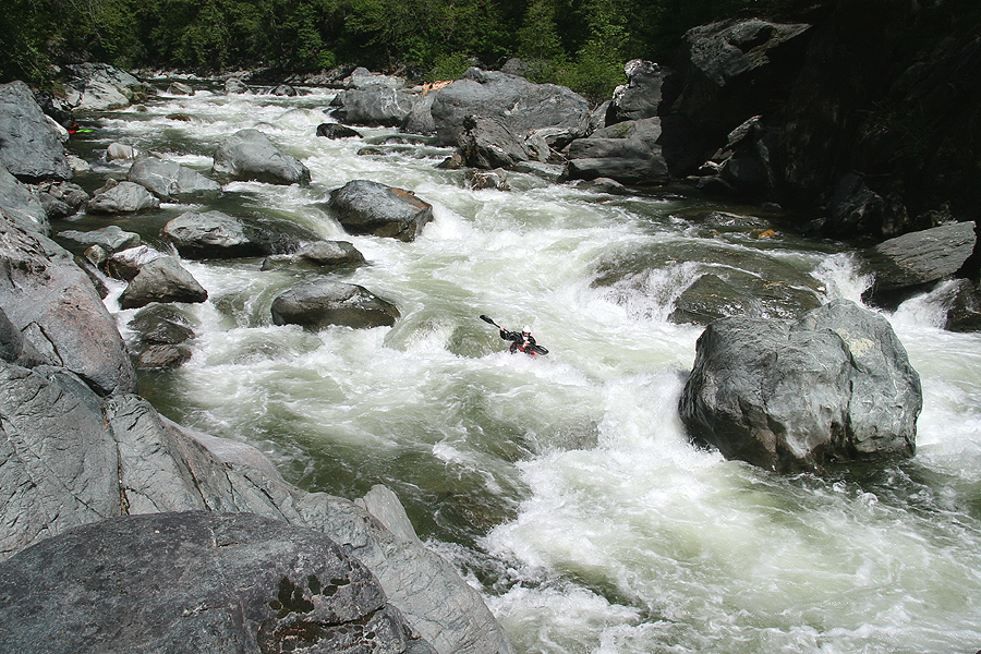
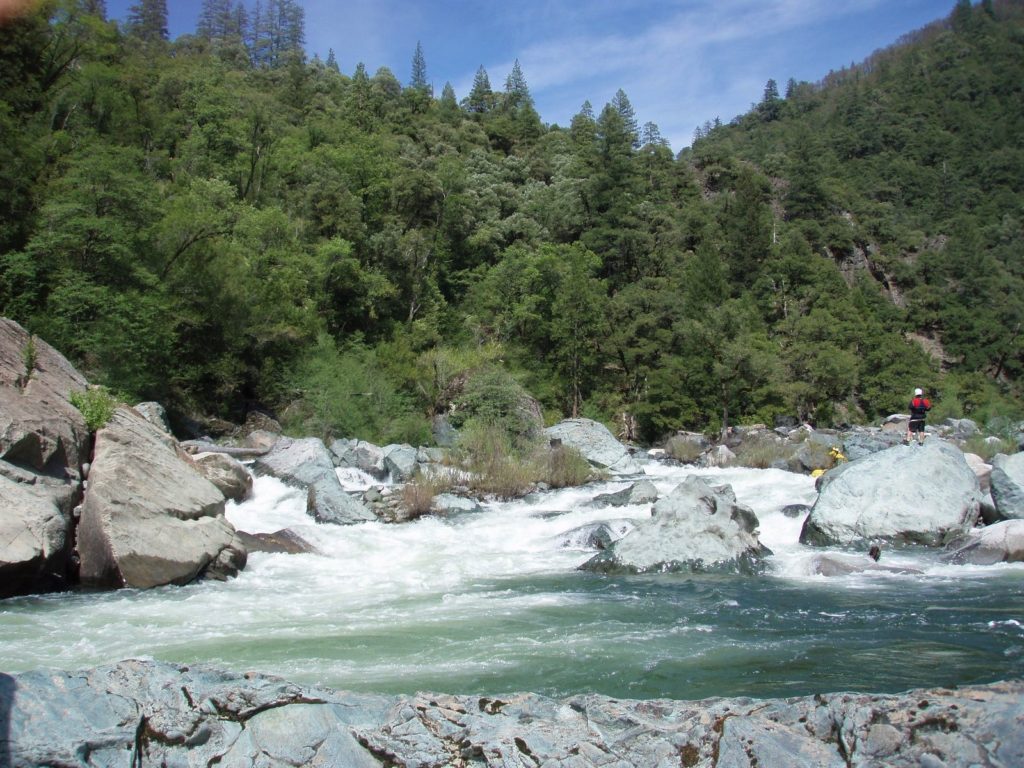
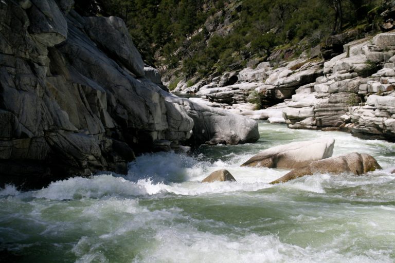
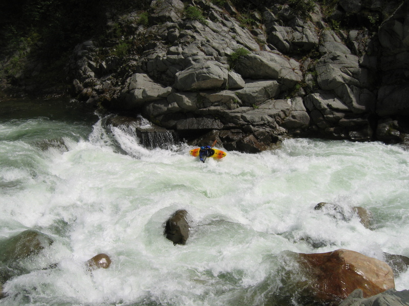
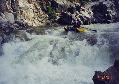
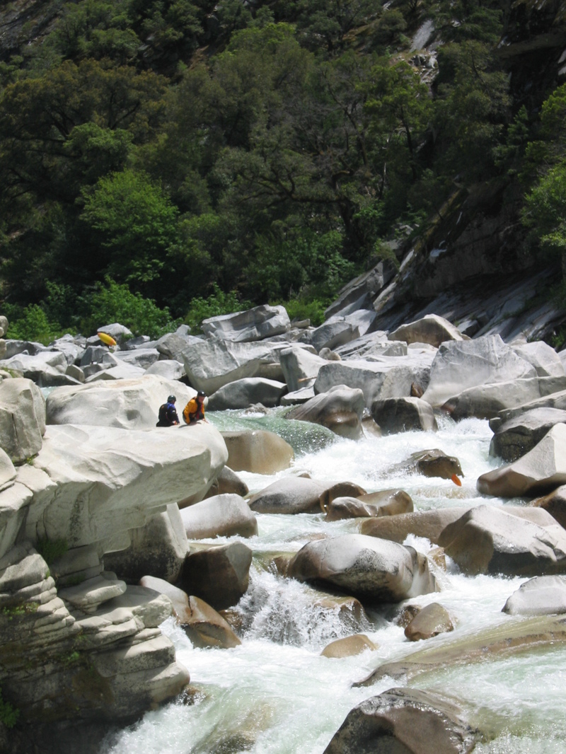
Day 3 generally starts in the vicinity of the Pacific Crest Trail footbridge at Hartman Bar, though camping here is not recommended due to litter, a lack of firewood, and the intrusion of hikers and the outside world. It soon begins to be obvious that a significant geological change is underway, and building granite walls and boulders signal the entrance to Devils Canyon proper. Many spicier rapids start to be encountered, amongst which are *Slide*, the product of an obvious slippage of the Canyon wall, *Sieve*, a portage around a major siphon at most moderate flows, and *Eat The Meat,* a meaty double drop with cliff on the right and bedrock shelf on the left that provides good spectating. Finally a burly and steep granite boulder garden rapid drops into a very large and still pool with huge looming granite cliffs on the left and this signals the mandatory portage which starts on the right from the head of the pool traversing steep forest on a well defined trail above the massive rapid bellow. Avoid dropping too low, too early, on the portage, and a little team work maybe required right at the end as exhausted boat porters try to lower there boats down the final awkward rock steps. Below here more spectacular granite canyon continues, with many more hard quality rapids and vertical walled sections. Eventually large granite slabs on river left with a waterfall trickling down herald the arrival of *Helicopter*, the well known must-run class V rapid with meaty triple hole punch and airplane turn finale all set against a vertical cliff left and a field of granite sieves right. Difficulties are increasingly farther apart after this and wooded canyon scenery replaces cliff walls, however major rapids still lurk, finally ending with *Grand Finale*, the last class V, with its commiting long class IV lead in via small pools on the left followed by a powerful move to ferry out into the outwash of a hole to avoid being pushed into the cliff on the left.
From here the river gradually tails off into Class III scenery and soon Milsap Bar bridge becomes visible just below the confluence with the Little North Fork Middle Fork Feather.
Rapids in this Run (10)


Waterfalls (1)
Hazards & Portages (1)
Caution: The following locations may require scouting or portaging. Always check current conditions.
Difficulty
Class V
Length
33.0 mi
Gradient
68 ft/mi
Rapids
10
1 Portage
Access Points
Shuttle Info
Directions to take-out:
From Oroville, CA, drive east on CA-162, “Oroville-Quincy Hwy,” for about 22 miles to the tiny town of Brush Creek. Turn Right on Bald Rock Rd and then almost immediately left onto Milsap Bar Rd. Unfortunately, the road does not currently go all the way to the river. You should see a sign telling you that the road is closed. As of this writing, there was a good place to park and pick up river runners about 2 miles up from the river. We don’t advise leaving a vehicle parked here for the entirety of your run, as there have been break-ins and vandalism in the past. The road is only experiencing a “temporary closure;” however, it could be years before it is reopened. However, checking road conditions with Feather River Ranger District at (530) 534-6500 for current information about road access as well as any other emerging hazards or safety issues. Another good resource is the Plumas National Forest website.
Directions to put-in:
The Put-in for Devil's Canyon is the Red Bridge on La Porte Rd just outside of Quincy, CA. There are multiple ways to get there from the Lake Oroville area. There’s the quickest way (A), and then there’s the most reliable way (B). Don’t trust Google for your decision here.
1. Most direct route from the take-out: If you are driving your own shuttle and are going directly to the put-in from the take-out then continue east on CA-162 for about 40 miles to the town of Quincy. Continue straight on to CA-70 East for 3.5 miles. Turn right on La Porte Rd. Drive 8 miles to Red Bridge Campground. The best place to launch is on River Right downstream of the bridge, but the best camping is on River Left just upstream from the bridge.
2. The second option is longer, but more reliable, and especially convenient if you are using a shuttle service or have a generous shuttle bunny. Drive back down to Oroville from the take-out then head north CA-70 for 86 miles, along the North Fork of the Feather (home to the famous class V Tobin section, class IV “Lowbin” section as well as the Rock Creek section and Cresta. Past Quincy, Turn right on La Porte Rd. Drive 8 miles to Red Bridge Campground.
Difficulty Classes
I Easy
II Novice
III Intermediate
IV Advanced
V Expert/Extreme
VI Unrunnable
Current Conditions
5-Day Forecast
Whitewater data from
American Whitewater
American Whitewater