2. Rocky Gorge to Lower Falls
Linked via: Nhdplus discovery 90% confidence Synced 6mo ago
Gauge Conditions
Runnable: ? – ? CFS
Approximate reading: This gauge is 55.8 miles away on Swift. Use as a general reference only.
Data from American Whitewater & USGS
Run Map
Description
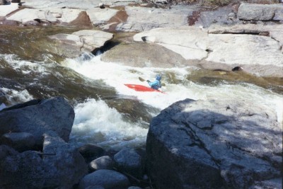
The Middle Swift is a very good intermediate run. This section of the Swift is sandwiched between two class V drops that can easily be by-passed. The rapids in between are a lot mellower mainly class III. The biggest drop in this section is Triple Drop; it is two 3' drops about 50' apart with a big wave/hole at the bottom. At lower water Triple drop should be considered class III+. A look at the take-out for this section is advised since you don't want to run Lower Falls without scouting.
The Swift runs along side the scenic Kancamaugus Highway in the White Mountain National Forest. It is not wild but still scenic, the road and tourist areas at the put in and take out can be crowded with curious people taking pictures or just gawking especially late in the Spring. Note: the above mentioned gradient information does not include Upper and Lower Falls. See also the Upper and Lower Swift.
### Technical info
```
Put in elevation.......1123'
Take out elevation.....940'
Distance...............2.6 miles
Total drop.............183'
Average drop/mile......70'.....Including Upper and Lower falls
1st mile drop..........85'......Includes Upper falls
2nd mile drop..........58'......Includes Triple Drop
2.6 mile drop..........40'.....Includes Lower falls
River width average....50'
River geology..........large granite boulders, some ledges at falls
River water quality....Excellent, crystal clear
Scenery................Excellent mountain and forest scenery.
Wildlife...............Some deer, moose, perrigrine falcons, tourist
```
Note: The technical information above includes Upper and Lower falls which greatly adds to the total and average drops on this relatively short river. The section in between the falls has less but very consistant gradient.
## Directions
### Put in
From Interstate 93.
Interstate 93 to exit 32.
State route 112 (Kancamaugus Highway) east for approximately 24 miles.
Approximately 3 miles pass Bear notch road look for the pull off for Rocky Gorge Scenic area.
From NH route 16.
Take a left on NH route 112 (Kancamaugus Highway), head west for approximately 9 miles to Rocky Gorge Scenic area.
The put-in is down a steep bank on river right just downstream from the foot bridge. Caution: do not put in at the parking lot.
Parking may be difficult in April due to snow and the bathroom facilities may be locked and unavailable.
### Take out
Head east towards Conway on the Kancamaugus Highway for 2.8 miles.
Take a left at the next tourist/scenic/picnic area signed Lower Falls.
Parking here should not be a problem in April due to snow because it is partially plowed but the bathroom facilities here may also be locked and unavailable.
Note: At the put-in and take out it will be necessary to have a White Mountain National Forest parking sticker. These can be purchased at the information center just off exit 32 on Interstate 93 on the west end of rt 112 (Kancamaugus Highway). Or at the National Forest Service information center at the intersection of NH routes 112 and 16 on the east end of the Kancamagus highway. It is also possible to buy a day pass from the self service kiosk at the Lower Falls recreation area.
Rapids in this Run (1)
Waterfalls (2)

Difficulty
Class II-III(IV)
Length
2.1 mi
Gradient
55 ft/mi
max 65
Rapids
1
Access Points
Difficulty Classes
I Easy
II Novice
III Intermediate
IV Advanced
V Expert/Extreme
VI Unrunnable
Current Conditions
5-Day Forecast
Whitewater data from
American Whitewater
American Whitewater