2. Service Creek to Clarno
Linked via: Manual fix 90% confidence Synced 6mo ago
Gauge Conditions
Runnable: 1,500.0 – 12,000.0 CFS
Data from American Whitewater & USGS
Run Map
Run Time Estimate
Select put-in and take-out to estimate time.
Unlock Advanced Trip Planning
See wind-adjusted speed maps, forecast planning, and detailed time estimates.
Sign in to generate an AI timing estimate for this run.
Whitewater timing varies with scouting, portages, and group pace. Use as a planning baseline.
Description
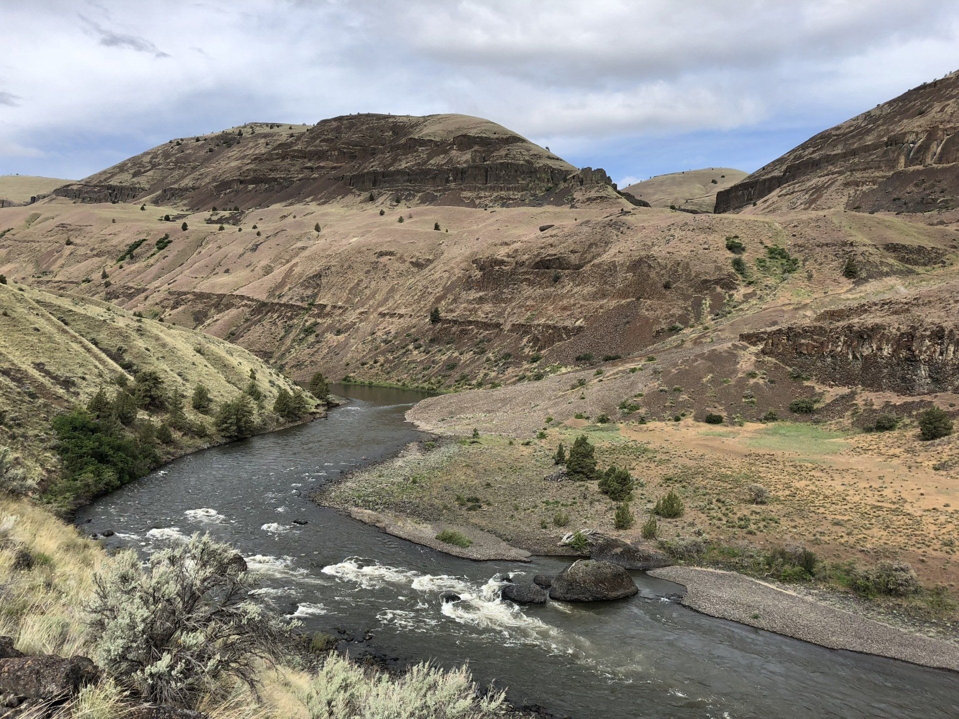
The full run is a multiday trip through cattle country and farmland, but there are also isolated stretches through a scenic, high-desert canyon. The highlights are three class II rapids (described below) and some excellent Eastern Oregon desert scenery, which includes the same colorful geologic formations that make up the nearby Painted Hills of the John Day Fossil Beds National Monument. Don't under estimate the rapids! The cost of a mistake on this remote river can be great.
Season: There are no dams on the river (but there are diversions for irrigation); flow is mostly dependent on snowmelt in the Blue and, to a lesser extent, Ochoco Mountains. The runoff generally peaks in April and May. Flow can drop to less than 1,000 cfs by July. It should be noted that bass fishers flock to the river in May and into June.
Regs/Permits/Etc.: The BLM requires an online permit year round, a river toilet for overnight trips, and a fire pan for having fires outside the annual fire ban season. Visit Recreation.gov for day use permits and overnight permits. For further information visit the John Day BLM website.
Directions to the Putin: If approaching from the north, take Oregon Highway 19 to Fossil. Continue south 19 miles and turn right (just past the Service Creek Trading Post) onto Oregon Highway 207. Continue 0.3 of a mile to the launch at the Donnelly Service Creek River Access Park. If approaching from the west, from Mitchell drive north on Oregon Highway 207 for 25 miles. The launch is just beyond the bridge over the John Day.
Directions to the Takeout: From Fossil, drive west on Oregon Highway 218 for 19 miles. The Clarno take-out is on the right (downstream side) of the bridge on the east bank. If youÂre coming from the west and are planning to leave a shuttle vehicle at the take-out on the way in, approach Clarno via Highway 218 from Antelope.
Alternatives: An Alternate putin is Muleshoe Recreation Area about two-and-a-half miles upstream from Service Creek. A day trip can be made from Service Creek to Twickenham Bridge (120.16562W 44.73665N). The highlight is Shoofly/Russo Rapid. Access Twickenham from the south by Girds Creek Road from Oregon Highway 207 13.9 miles west of Service Creek, or access Twickenham from the north via Rowe Creek Road from Oregon Highway 19 ten miles northwest of Service Creek. The BLM has made some improvements in recent years (including adding a vault toilet) to this access point. Access is also available farther downstream between river mile 137 and 138 at Priest Hole (120.27082W 44.73909N). To reach Priest Hole drive west from the Twickenham Bridge for eight miles on South Twickenham Road. This road becomes rugged and the last couple of miles aren't recommened for cars. A new access point, Lower Burnt Ranch, near river mile 131. The ramp is steep and the approach is not recommended for cars.
The Rapids
All are class II.
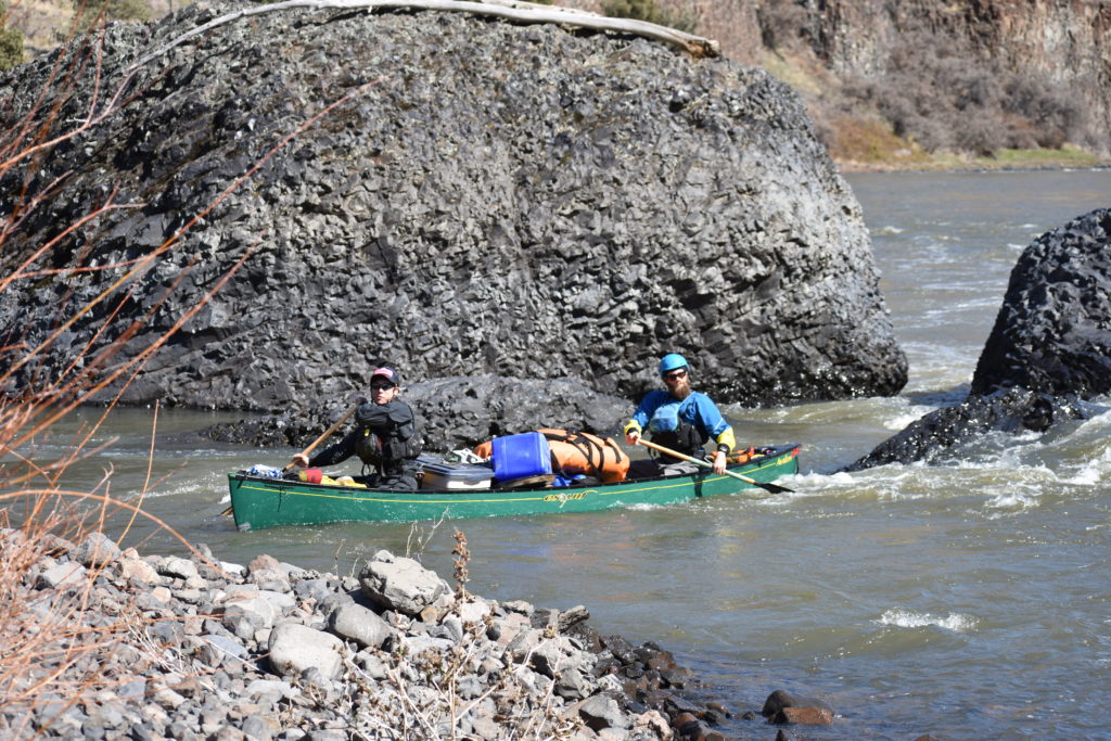
_Shoofly/Russo Rapid_ (120.09089W 44.76267N) is just above river mile 150 as the river turns to the left. Land at the top of the turn on the right if you're going to scout. There are some standing waves and holes toward left; but most of it could be avoided by holding right. The current goes into the cliff near the bottom at left. There can be a small, but nice, wave train along the bottom at the cliff if the flow is right.
_Fossil Rapid_ (120.2508W 44.74783N) is just above river mile 132. It's a short drop that can be rocky. The current goes headlong into a cliff at bottom right.
_Burnt Ranch Rapid_ (120.35569W 44.74133N) is above river mile 132. The river takes a hard left and then turns right after the rapid begins. Land on the sandy beach on the left to scout. For a straight line through the rapid, set up close to the large rock near river center at the rapid's top. (Canoe's that take a line just to the left of the rock seem to take on less water.)
Books: At least two guides describe the run in some detail: _Soggy Sneakers, A Guide to Oregon Rivers,_ Willamette Kayak & Canoe Club (ISBN 0-89886-330-9), and _Oregon River Tours,_ John Garren (ISBN 0-941887-01-4). _Soggy Sneakers,_ is geared toward kayakers and canoeists. Garren's book contains a river log (logged in a raft). A book that is hard to find, _John Day River Drift and Historical Guide,_ by Arthur Campbell (ISBN 0-936608-11-0), is dated but contains a log and much history.
NOTE: The coordinates used on this page were field verified in 2002 with a 12-channel Garmin e-Trex.

Difficulty
Class II
Length
47.8 mi
Gradient
8 ft/mi
Rapids
7
Access Points
Difficulty Classes
I Easy
II Novice
III Intermediate
IV Advanced
V Expert/Extreme
VI Unrunnable
Permit Required
Online permit required from Recreation.gov year-round.
Get Permit
Current Conditions
5-Day Forecast
Whitewater data from
American Whitewater
American Whitewater