3. Cedar Flats to Upper Twin Creek
Linked via: Proximity 97% confidence Synced 6mo ago
Gauge Conditions
Runnable: 1,000.0 – 10,000.0 CFS
Data from American Whitewater & USGS
Run Map
Run Time Estimate
Select put-in and take-out to estimate time.
Unlock Advanced Trip Planning
See wind-adjusted speed maps, forecast planning, and detailed time estimates.
Sign in to generate an AI timing estimate for this run.
Whitewater timing varies with scouting, portages, and group pace. Use as a planning baseline.
Description
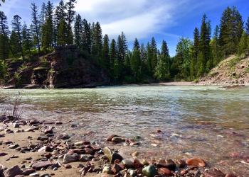
This lower segment of the Wild and Scenic South Fork Flathead River is below Meadow Creek Gorge and can be accessed from the forest road that parallels the river. The river has a handful of standing waves and sections of deep slow water. It is know for its fishing which is catch and release. The river is classified as Wild upstream of the Spotted Bear River confluence and classified as Recreational downstream to the reservoir.
The Spotted Bear Campground is along this section and just downstream of the Spotted Bear River confluence but not accessible from the river. It has 13 sites and is available from mid-May until the end of September.
The section ends at Hungry Horse Reservoir created in 1953 with the construction of the 564' Hungry Horse Dam.
Rapids in this Run (2)
Difficulty
Class II
Length
14.9 mi
Gradient
14 ft/mi
Rapids
2
Access Points
Difficulty Classes
I Easy
II Novice
III Intermediate
IV Advanced
V Expert/Extreme
VI Unrunnable
Current Conditions
5-Day Forecast
Whitewater data from
American Whitewater
American Whitewater