3. Highway 101 to river mouth (ocean surf)
Linked via: Proximity 95% confidence Synced 6mo ago
Gauge Conditions
Runnable: 500.0 – 2,000.0 CFS
Data from American Whitewater & USGS
Run Map
Run Time Estimate
Select put-in and take-out to estimate time.
Unlock Advanced Trip Planning
See wind-adjusted speed maps, forecast planning, and detailed time estimates.
Sign in to generate an AI timing estimate for this run.
Whitewater timing varies with scouting, portages, and group pace. Use as a planning baseline.
Description
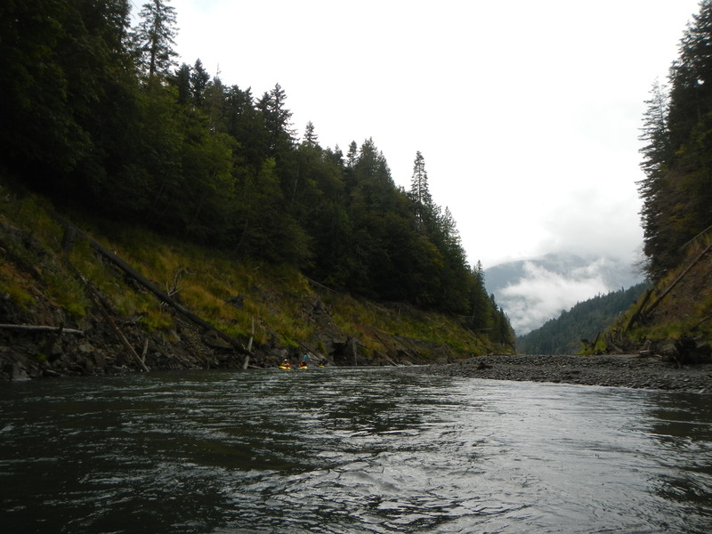
This run offers an opportunity to explore a restored river follwing dam removal. Flows are typically best after a good winter rain or during snowmelt (November to June), but the river can be boated throughout most of the year. With the Elwha Dam gone, the Elwha River is still developing a new river channel through the reservoir sediments of the historic Aldwell Reservoir that begins at the put-in from the Highway 101 bridge. Use caution through this section as fish habitat structures have been constructed in this reach and wood hazards are constantly shifting with the channel is in a state of flux. This section is a fascinating landscape of old tree stumps from when the forest was cleared a century ago prior to construction of the Elwha Dam. While the whitewater is not difficult the wood hazards demand respect and this section is no place for inexperienced paddlers. You can easily scout the upper section of the reservoir and explore the old reservoir from the old reservoir boat launch (see logistics below).
After you pass through the upper section of the old reservoir, the river cuts through a short canyon at the Gooseneck before opening up into the lower section of the old reservoir. Soon you approach the Elwha Canyon that was once blocked by Elwha Dam.
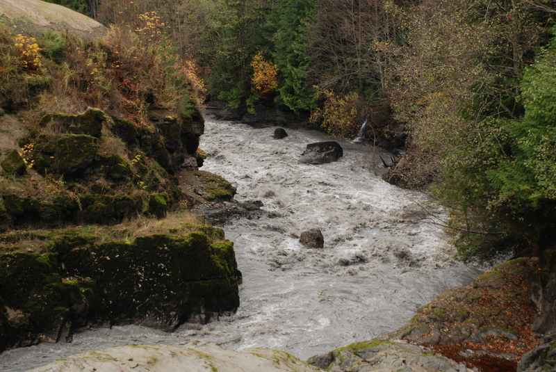
The rapid at the former dam site is known as That Dam Rapid. If you are traveling downriver you can pull out on river left and climb up the slope to get a partial view of the rapid. Although you can not see much from scouting on this side, it is the best portage option if you do not want to run the drop. A better view of the rapid is available from river right but it's more challenging to get to the best vantage point from river level. It's easy to get there if you drive down before your run.
That Dam Rapid starts with a short entry rapid before the river explodes below through a class IV+ cascade of boulders and holes that is a technical drop at lower flows or a bigwater rapid at higher flows. At moderate flows the standard move through the main drop is to set up in a nice eddy on river right, start right through the rapid, clear the first hole on river left, and work quickly to the tongue on river left to avoid more rocks and holes on river right. Note that the rapid still has some construction debris that was left behind with dam removal so use caution.
Just downstream of the dam site the river flows through a scenic gorge with some class II rapids. A short stretch of flatwater comes before another class II rapid on the upstream side of the Highway 112 bridge.
Once you pass under the Highway 112 Bridge the river continues to migrate back and forth across the floodplain as sediment from behind the old dams moves through this section.
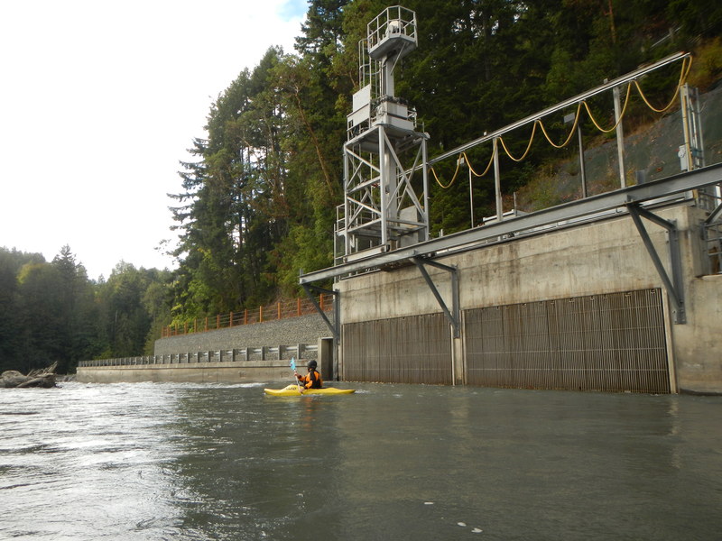
As you approach the new Elwha Road Bridge, you will pass by the intake for the water treatment plant and an engineered riffle. In some seasons ta fish weir just upstream of this point will likely need to be portaged. The bridge has an upper deck for cars and a lower deck for the Olympic Discovery Trail, a great trail if you are looking for other activities in the area to keep you busy (the trail includes two routes, the standard route and the adventure route featuring great singletrack).
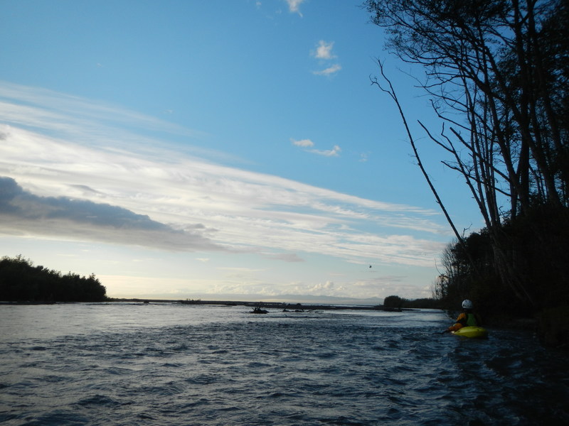
Once you pass under the old Elwha Road Bridge the character of the run changes as the gradient tapers off a bit and the channel becomes more braided. At moderate flows this section has a few rapids, but also a lot of wood--both engineered and natural log jams. By continuing all the way to the ocean you can end your trip with a bit of ocean surf and experience the new beach that has formed at the mouth of the Elwha River.
Access Logistics:
Put-In: From Port Angeles take 101 west to mile 239.5 and the bridge across the Elwha River that provides access on river right. If you want to scout the first part of the run continue across to the west side of the bridge and at Highway mile 239.4 Turn right (north) onto Lake Aldwell Road. Continue on the road 0.2 mile to the end and the old boat launch that was on the reservoir. From here you can hike out onto the old reservoir and spend several hours exploring the former reservoir which is a fascinating landscape of sediment held back by the dam and old tree stumps from the forest that was cut down prior to flooding the reservoir.
Take-Out: From Highway 101 mile 242.5 turn onto Highway 112. Head 2.1 miles west (crossing the river) to Place Road. Turn right (north) and follow this road 1.9 miles to the T junction and then turn right (east) continuing on the short lane to the Elwha Dike access point. Day-use parking is available along the road. Hike a couple hundred yards along the trail towards the ocean for the take-out or park-and-play surfing. Note that private access points that were once used on river right to gain access to the surf at Angeles Point are now closed to the public. An alternate take-out is a couple miles upstream of the mouth on river right under the Elwha River Road bridge.
Visit the Dam Site: Historic access was available at the base of the dam and you can go visit the site which enables you to scout That Dam Drop (recommended if you plan to portage or run this drop). From Highway 101 mile 242.5 turn onto Highway 112. Take this road 0.7 miles and just before reaching the Elwha bridge turn left (south) on Lower Dam Road, and turn into the parking lot for the trailhead to the overlook. You can also follow Lower Dam Road 0.4 mile down to the dam site where you will find a trail that leads to the pool below the old dam site. This is a long, steep, and potentially slippery social trail that in the past was the only way to launch kayaks at the base of the dam. Alternatively you can easily hike to an overlook where the river right abutment of the dam was. This provides the best overall view of the rapid.
for additional information see:
Olympic National Park website
Korb, G. 1997. A paddlers guide to the Olympic Peninsula. third edition.
Bennett, J. and T. Bennett. 1997. A guide to the whitewater rivers of Washington, second edition. Swiftwater Publishing. Portland, OR.
Rapids in this Run (4)
Difficulty
Class II-III(IV)
Length
7.4 mi
Gradient
23 ft/mi
Rapids
4
Access Points
Difficulty Classes
I Easy
II Novice
III Intermediate
IV Advanced
V Expert/Extreme
VI Unrunnable
Current Conditions
5-Day Forecast
Whitewater data from
American Whitewater
American Whitewater