3.) Route 98 to Lake Erie
Linked via: Nhdplus discovery 90% confidence Synced 6mo ago
Gauge Conditions
Runnable: 4.7 – 5.5 FT
Lower Elk pretty accurately reflects the flow of Walnut Creek, 5 hours later. So, if you see a spike on the Walnut gauge, expect Girard to peak about 5 hours l
Data from American Whitewater & USGS
Run Map
Description
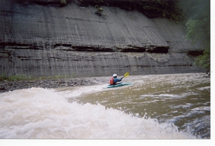
Elk Creek is a lot of fun for beginners and good for surfing. It is a typical Lake Erie type stream (shale gorge.) There is a really good set of surfing waves about 2 miles downstream of the put in. This rapid is called "Double Razorblade." The first wave is the best wave on this section. Otherwise, most of the good surfing is below Girard. One of surfing spots has a nice river wide hole about 200 yards above the first railroad bridge below Girard. This rapid is called "Upper Railroad." Another good one is 200 yards below a bridge about half way between Rt 20 and the lake, and the last is one of the best with an assortment of holes and waves just upstream of the last railroad bridge called "Lower Railroad." The creek moves along pretty well and there is never more than 200 yards without a ripple.
Alternate access is located in Girard and is about 8 miles below Route 98. There is a good put-in / take-out at a closed bridge located just upstream of the Route 20 bridge. The run below here is an excellent after work run if you live or work on Erie's west side. It is a 5 mile run to the lake from here and is generally a little more entertaining than the upper stretches of this section. 0.75 ft is ideal for this section on the painted gauge at the West Road bridge across Elk in Sterretania. The electronic gauge on Walnut will usually read near 4.75 ft for the best surfing. The minimum level for this section will usually be about 4.65 ft on Walnut.
The regular put-in is at Folley's End Campground. You can park on the road that goes down to the campground and carry about 100 yards to the water.
The take-out is at Elk Creek Access area. From Route 5 West, you will see a sign for Elk Creek Access Area. There is a nice parking lot here and it is close to the water.
Playspots (1)
Difficulty
Class I-II
Length
13.2 mi
Gradient
18 ft/mi
max 25
Rapids
0
Access Points
Shuttle Info
The regular put-in is at Folley's End Campground. You can park on the road that goes down to the campground and carry about 100 yards to the water.
The take-out is at Elk Creek Access area. From Route 5 West, you will see a sign for Elk Creek Access Area. There is a nice parking lot here and it is close to the water.
Difficulty Classes
I Easy
II Novice
III Intermediate
IV Advanced
V Expert/Extreme
VI Unrunnable
Current Conditions
5-Day Forecast
Whitewater data from
American Whitewater
American Whitewater