4. Brown Bridge Road to Hwy 212 (above Lake Jackson)
Linked via: Proximity 73% confidence Synced 6mo ago
Gauge Conditions
Runnable: 400.0 – 3,000.0 CFS
Data from American Whitewater & USGS
Run Map
Description
Shuttle directions.
From I-20 take Hwy 81 South from Covington and the run starts in downtown Porterdale.
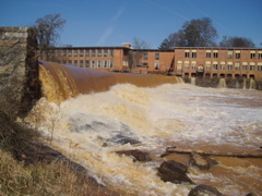
When you see the mill, you are at the put in.
There is an abandoned gas station on the North side of the bridge that has been used for parking.
The best put in is to put into the river on the northwest corner of the bridge on public property. Then
float a few yards down to take out just before you reach the 12 foot high dam. Portage on river right
and put back in just below the dam.
To get to the take out, go North on Hwy 81 close to the edge of town and turn right on River Front Road.
Follow the road till you get to the river on the right. There is a parking area with a trash can.
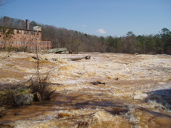
The run is about 1/4 mile of III+ ledges then about a mile or two of II-III.
AT HIGHER WATER THIS RUN INCREASES DRASTICALLY IN DIFFICULTY
Rocky Plains Road or Pickett Bridge are probably better and shorter takeouts.
The major rapid on this section in Porterdale is at Cedar Shoals.
Unfortunatly it is now posted so the area might be closed to boaters. For more info see the comments below. Local boater Will Gosney has talked to area authorities and has been given a green light to paddle the river.
Will Gosney: 2004-11-14: We ran at about 340 cfs and is was still too low. I would think about 500+ would be more realistic. No problems from the police or residents about portaging the dam on river right.
At very high water levels, it appears that several undercut rocks would come in to play and you might want to avoid the big (house sized) rock on river right at the end of the run as it is undercut and the current might flow that direction.
Rapids in this Run (2)
Hazards & Portages (1)
Caution: The following locations may require scouting or portaging. Always check current conditions.
Difficulty
Class III-IV(V+)
Length
14.6 mi
Gradient
30 ft/mi
max 60
Rapids
2
1 Portage
Access Points
Difficulty Classes
I Easy
II Novice
III Intermediate
IV Advanced
V Expert/Extreme
VI Unrunnable
Current Conditions
5-Day Forecast
Whitewater data from
American Whitewater
American Whitewater