4) Lake Piru to Santa Clara River
Linked via: Nhdplus discovery 90% confidence Synced 6mo ago
Gauge Conditions
Runnable: 150.0 – 1,000.0 CFS
Data from American Whitewater & USGS
CDEC Flow Data California
Data from California Data Exchange Center (CDEC)
Run Map
Run Time Estimate
Select put-in and take-out to estimate time.
Unlock Advanced Trip Planning
See wind-adjusted speed maps, forecast planning, and detailed time estimates.
Sign in to generate an AI timing estimate for this run.
Whitewater timing varies with scouting, portages, and group pace. Use as a planning baseline.
Description
As of 2020 the best section to boat is reported to be between the upper bridge and the second bridge. The channel is reported to be reasonably clear of brush in this section but filled with brush in the sections above and below. Put in at the first bridge and take out at the second bridge.
Fall Releases: In years when there is enough water in Piru Reservoir, United Water Conservation District has fall releases into the creek to recharge groundwater in the Santa Clara River valley. Releases usually start in early September and extend through mid October. Flows usually start around 400 cfs, then gradually drop to 250 cfs over the course of the release. The actual timing and flows vary from year to year and are not guaranteed.
Dam Put in Access: Boaters seeking access to the put-in site on the District property must make reservations at least 24 hours in advance by sending an email to with your request and contact information. All boaters accessing Piru Creek from the District property must read and sign a waiver form. The form must be signed before access will be given – no exceptions. Access to the upper put in below the dam on District’s property will be limited to Saturdays and Sundays between 9 a.m. and 3 p.m. Vehicles left in the parking area must leave by 4 pm.
For more information, call United Water Conservation District at (805) 525-4431 United Water Conservation District
Warning: Measuring instruments mounted on metal posts have been placed in a number of locations along the creek. These posts may present navigation or broaching hazards. Be on the lookout.
2011 Fall Releases: September 12 to October 27.
2010 Fall Releases: Releases of about 400 cfs are expected to start on September 17. Put in shuttles will start on Saturday and Sunday Sept. 18 & 19. The release is expected to drop below 200 cfs in early November. Flows will drop in 50 cfs increments over the course of the release. See the calendar for flows on specific dates.
2009 Fall releases: Flows of 250 cfs will start on September 11 and run through October 28, according to United Water's release schedule. The 250 cfs flow is a low moderate level. Flows and dates are posted on the United Water website and on the AW calender on the right side of this page.
There will be escorted access given on weekends at specific times for boaters to put in below the dam and take out at the park in the town of Piru. UW intends to create a listserve on their site to notify the public of the release and access conditions. AW will also post that information here, on our calender and in news releases.
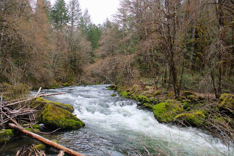
Overview: From the dam down to the spillway channel is reported to be very brushy with narrow channels and some confusing forks for the first 1/2 mile. Flows come from a hydro plant outlet which provides low and steady flows almost all year long. This encourages the heavy vegetation growth. After 1/2 mile the outlet channel joins a more scoured channel coming from the dam spillway.
From the upper highway bridge down into town the creek tends to be busy with lots of long riffles. The banks are usually thick with greenery. In spots the brush grows out into the channel and in some years has been so thick as to present a hazard. In 2007, the channel was always clear. The stream side brush does provide a feeling of seclusion for most of the run while the canyon walls rising above offer interesting lessons in coast range geology.
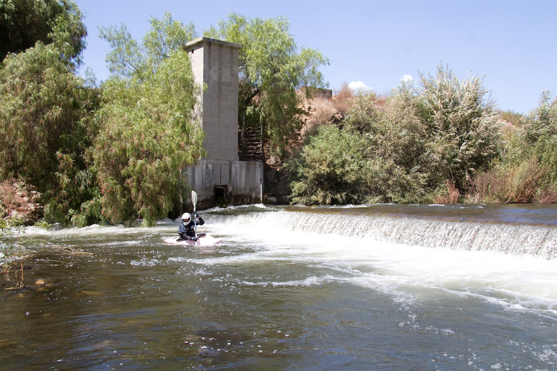
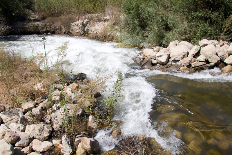
Below town the creek bed is generally wide, shallow and often braided. It has a barren feel, but with nice views of distant mountains. This section would be most interesting in the early morning or evening rather than the middle of the day. There is a diversion dam of sorts and a steep rocky drop underneath the next bridge downstream of Warring Park. Shortly past that in 2007 was another trouble spot with a number of driftwood trees and a pipe clogging a drop. There was a route through the mess but it would give beginners trouble.
Put in: The highest put in is a few hundred yards below the dam. This access is only available to boaters during Fall releases, on Saturdays and Sundays from 9 am to 3 pm. Make reservations 42 hours in advance by calling United Water Conservation District at (805) 525-4431. Park at a turnout marked with a sign for a boater shuttle. United Water personel will shuttle boaters down to the creek. There is a good play spot at this put in and one additional significant rapid before the first bridge access. The first half mile of this section is reported to be very overgrown with bushes and overhanging trees, leading to considerable danger, excitement and difficulty in the fast water. Tree saws and pruning shears may be recommended for the first few trips each year.
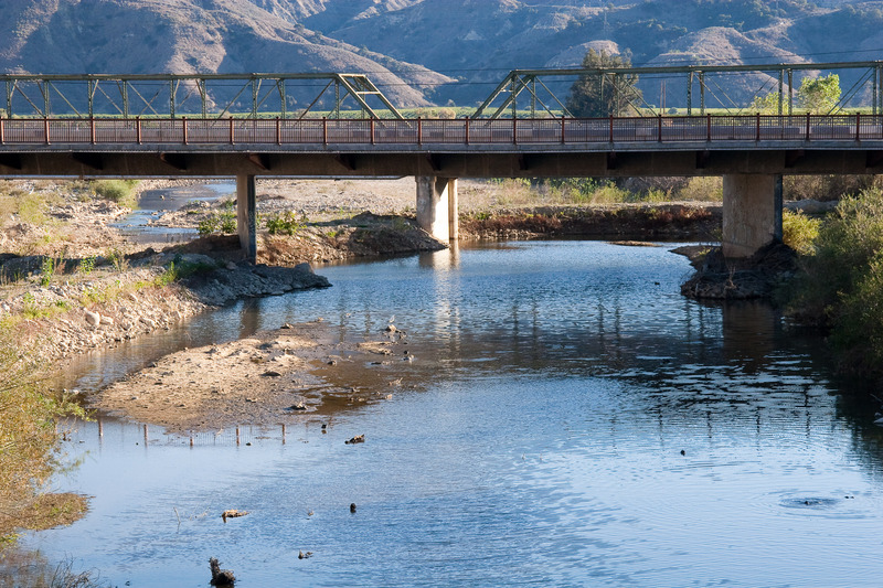
A commonly used put in is at the first bridge, about 1.3 miles below the dam. There is a narrow shoulder for parking and fences come right up to the bridge. There is a 30 foot public easement on either side of the center line of the road. Stay within that easement to access the creek. This means that you should lower boats and climb down as close to the bridge as possible. The fence on the southeast corner of the bridge is about 27 feet from road center, so legally there is another 3 feet beyond that is public. On the southwest corner the fence comes to about 20 feet from road center and more effectively blocks access to the streambed. Note that the creek drops off on the downstream side of the bridge.
If someone from Rancho Temescal stops while you are preparing to boat, they may try to convince you that it is not legal to boat on the creek or not legal to launch from the bridge. Be polite and diplomatic, but insist on your right to launch there and to float the creek. They will probably not attempt to stop you from boating but will just try to convince you to leave. If they can convince you to leave without boating, then it does not matter whether you have a legal right to boat. See Legal Access Rights on Piru Creek.
Take-out: at Warring Park under a railroad bride at the upper end of the town of Piru. There is a large parking area at this park, and there are bathrooms, picnic tables and sheltered areas. This is a good place to change and get ready for boating. You can also continue on below town to the Torrey Road bridge, where there is parking on either side of the road. From Warring Park to Torrey Road is mostly spread out and often braided.
\--------------------------------------------
Kevin Mokracek writes:
This is an easy run. If you live in the area it is worth hitting. Be aware of where you park and make sure you DO NOT cross fences. There have been issues with the property owner who owns most of the land below the dam. The run from the bridge below the dam to down below Hwy 126 is generally class II but there can be a few technical III's. I have done this run dozens of times in the past several years. It has ranged from brushy to clear depending on winter flood releases from the dam. The play is better above town than below. If you are a serious playboater you will be disappointed. If you only get out on a river one or two times a month or less then this is a fun afternoon run just for the sake of being on water. If you live in the area you should definitely do it. It is nothing like Upper or Middle Piru. From the dam into the town of Piru is easy class II with maybe a few class III rapids. From town into the Santa Clara River bottom is Class I-II. Be courteous to the locals
\-----------------------------------------------
Other Information: In the upper reach, Piru Creek flows through Rancho Temescal, owned by the Cohen family and managed by Tim Cohen. If someone from this ranch stops while you are preparing to boat, they may try to convince you that it is not legal to boat on the creek or not legal to launch from the bridge. Be polite and diplomatic, but insist on your right to launch there and to float the creek. They will probably not attempt to stop you from boating but will just try to convince you to go away. If they can convince you to leave without boating, then it does not matter whether you have a legal right to boat or not. Legal Access Rights on Piru Creek, documents AW communication with the Ventura Sheriff in 2000 after the land owner prevented or tried to prevent boaters from using the reach.
'Immediately below the dam and also south of the project are agricultural lands associated with Rancho Temescal. Rancho Temescal is a 6,000-acre working ranch that once was opened to the public. (The Ranch is no longer open to the public.) Farm Bureau Story about Rancho Temescal Dude Ranches United Water Conservation District Page Legal Issues Santa Felicia Project: FERC #2153 Geological and water characteristics Fish Studies Santa Clarita Geology Santa Clara River Parkway Friends of the Santa Clara River
Ventura County road encroachment permit desk is open Monday through Friday 8:00 AM to 4:30 PM., at (805) 654-2055. They should have info on road right of way at the put in bridge.
FERC Information:
The Santa Felicia Project: FERC #2153 in 2007 is in the final stages of relicensing. To find documents related to this project go to the FERC elibrary, general search page. Enter 'P-2153' in the docket box. To limit the search to environmental issues, also enter '-012' in the subdocket box. A final Environmental Assessment was issued by FERC on January 23, 2007. It is available online at http://elibrary.ferc.gov/idmws/File\_list.asp?document\_id=4473031
Excerpts from the Final Environmental Assesment:
Middle and Lower Piru Creek Recreational Resources United proposes to notify American Whitewater and its affiliates of annual conservation releases, including the schedule and estimated flow rates. United proposes to post the schedule on its website (www.unitedwater.org) for current lower Piru Creek flow conditions and scheduled conservation releases or spills from Santa Felicia dam. United also proposes to communicate with the boating community through the establishment and administration of an email list serve. Notification of releases and spill events would be communicated by August 15 regarding annual fall conservation releases. United proposed, as part of its application, a take-out area for whitewater boaters, including a boat ramp and parking area, adjacent to the Forest Service closure gate near the Juan Fernandez Boat Launch swim beach area, and implemented this measure in fall 2004 (see figure 30, appendix A). This measure was implemented to allow whitewater boaters entering Lake Piru from the middle reach (upstream of Lake Piru and downstream of Pyramid Lake) to paddle along the western shore to this take-out area due to closure of public whitewater boating egress previously provided at Blue Point Campground. United also proposes to continue to negotiate with Ventura County and neighboring private property interests to secure access at the upstream Piru Canyon Road bridge crossing downstream of Santa Felicia dam (see figure 30, appendix A). United received preliminary notice from Ventura County that its easements constitute public access. If access is secured, United proposes to relocate the existing fences and grade an area to provide parking adequate for at least 20 vehicles. A 4-foot-wide spring-closing gate would be installed with a foot trail graded to the creek. Until such time that the bridge access improvements are implemented, United proposes to provide restricted and escorted access to the gage (USGS gage no. 11109800, Piru Creek below Santa Felicia dam) access site for 1 hour each weekend day of the annual conservation release. All vehicles would need to leave this location following equipment off-loading and all vehicles and equipment would be subject to security inspection. The Sierra Club *(letter from K. Schmidt, River Touring Section, Angeles Chapter, Sierra Club, Granada Hills, CA, to the Commission, dated May 20, 2005)* comments that United's proposed put-in access point would cut off about 1.5 miles of a 4.7-mile run, which is not acceptable to the boating community. American Whitewater and Sierra Club comment that the permanent access location should be located at the gage below the Santa Felicia dam *(letter from D. Steindorf, American Whitewater, and K. Schmidt, Sierra Club, to the Commission, dated January 12, 2006)*. Sierra Club also comments that United should consider options such as escorted access or a shuttle that would drop boaters at the river directly below the dam and that United should provide the means for an adaptive management plan for boating access based upon boating use. The Sierra Club also states that United should provide portage access around the project dam *(letter from K. Schmidt, River Touring Section, Angeles Chapter, Sierra Club, Granada Hills, CA, to J. Dickenson, United, dated December 17, 2004)*. Rick Norman *(letter from R. Norman, Monrovia, CA, to the Commission, dated May 16, 2005)* comments that although United's proposal to seek access at the bridge crossing is of interest to the whitewater boating community, it is a poor substitute for the upper put-in and superior upper section whitewater boating opportunities. American Whitewater and Sierra Club *(letter from D. Steindorf, American Whitewater, and K. Schmidt, Sierra Club, to the Commission, dated January 12, 2006)* comment that they support the idea of interim escorted access to the put-in location at the USGS weir, downstream of the dam, until permanent access is secured. They state, however, that a 1-hour window, as proposed by United, is inadequate, due to logistics and the desire for most whitewater boaters to complete two runs per day and recommend that United provide escorted access between 9:00 a.m. and 3:00 p.m. on weekends during the 2- to 6-week flow release period. Our Analysis United's proposed notification process of providing information on its conservation release flows through its website and an email list serve would help whitewater boaters take better advantage of these whitewater boating opportunities within the project area. Methods for this notification may need to be updated as new technology becomes available over the term of a new license. We note however, that United is also proposing to provide fine sediment flushing flows for habitat enhancements in lower Piru Creek. Although the magnitude of these flows has not yet been determined, it could be sufficient to provide additional whitewater boating opportunities at the project. Utilizing United's website and email list serve to notify interested parties of the fine sediment flushing flow, if of a magnitude satisfactory to provide recreational whitewater boating, would help whitewater boaters take better advantage of these whitewater boating opportunities, as well. For middle Piru Creek boating access, United's recently implemented egress at the swim beach area adjacent to the Forest Service closure gate area provides adequate means for whitewater boaters to take-out from boating runs on the middle Piru Creek. For lower Piru Creek boating access, as stated by the Sierra Club and Rick Norman, the proposed access would cut off a portion of the whitewater boating run in the lower Piru Creek. United acknowledges that a portion of the run is not realized by putting in at the proposed access location; however, United comments that unfettered access to the gage location immediately downstream of the dam should not be provided due to security issues at Santa Felicia dam. United's proposal for providing interim restricted and escorted shuttle access for private vehicles would provide the means for whitewater boaters to access sections of the lower Piru Creek for whitewater boating opportunities until permanent access is obtained for this whitewater boating run. However, as American Whitewater and Sierra Club comment, a 1-hour window could prove to be problematic and limit whitewater boating opportunities during the interim period. Extending the period for interim whitewater boating access from 1 hour to 6 hours during weekends between the 9:00 a.m. and 3:00 p.m. period when conservation releases and fine sediment flushing flows occur would provide more sufficient opportunity for whitewater boaters to access sections of the lower Piru Creek for whitewater boating opportunities until permanent access is obtained for this whitewater boating run. Provision of a whitewater boating access in lower Piru Creek would provide enhanced means for boaters to access the lower Piru Creek during conservation releases in the fall when water is released from Santa Felicia dam and during the release of flows for sediment flushing. In addition, provision of a portage around the dam would allow for whitewater boating access between middle Piru Creek (between Pyramid Lake and Lake Piru) and lower Piru Creek (below Santa Felicia dam). As with most recreational facilities around hydroelectric project dams, we must consider the safety of the public, suitable public access to those recreational opportunities provided by the project, and property ownership when assessing placement and availability of public access. Assessment of the feasibility of providing portage access around the project dam and selection of the whitewater boating access location, including access at the USGS gage no. 11109800 location below the Santa Felicia dam, should consider both public safety and providing an access that takes best advantage of the whitewater boating run opportunities in lower Piru Creek. We discuss the cost of developing and implementing recreation measures in section VI, Developmental Analysis. We present our final recommendations pertaining to recreation in section VII, Comprehensive Development and Recommended Alternative.
Rapids in this Run (3)
Hazards & Portages (3)
Caution: The following locations may require scouting or portaging. Always check current conditions.
Difficulty
Class II+(III)
Length
6.7 mi
Gradient
37 ft/mi
max 39
Rapids
3
3 Hazards
Access Points
Shuttle Info

Difficulty Classes
I Easy
II Novice
III Intermediate
IV Advanced
V Expert/Extreme
VI Unrunnable
Current Conditions
5-Day Forecast
Whitewater data from
American Whitewater
American Whitewater