4) Stone Valley: Colton to Brown's Bridge
Linked via: Nhdplus discovery 90% confidence Synced 6mo ago
Gauge Conditions
Runnable: 500.0 – 2,000.0 CFS
Real-time flow information not dependable. Use flow forecast provided by Reliant Stone Valley Forecast. (See 'Flow Info' tab.)
Data from American Whitewater & USGS
Run Map
Run Time Estimate
Select put-in and take-out to estimate time.
Unlock Advanced Trip Planning
See wind-adjusted speed maps, forecast planning, and detailed time estimates.
Sign in to generate an AI timing estimate for this run.
Whitewater timing varies with scouting, portages, and group pace. Use as a planning baseline.
Description
## Stone Valley Guide Video
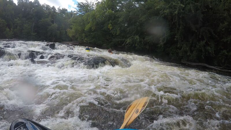
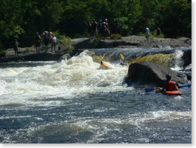
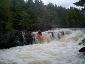
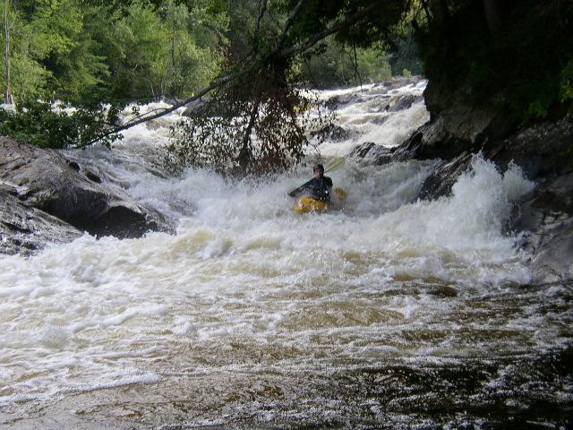
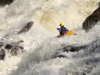
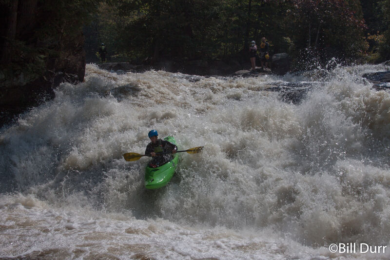
Stone Valley is a classic Adirondack run with a pool-drop character. The noted difference from other runs in the region is that the rapids are much closer together in Stone Valley. The first mile drops 200' through seven distinct rapids separated on average by 100-200 yards. The greatest distance between any two rapids is only 400 yds. One unique and potentially dangerous characteristic is that the river flows against the "grain" of the bedrock, creating piton features and potholes which are especially noticeable at flows below 600 cfs. (Few if any pins have been reported with over 500 runs being made though the spring of '04.) The last two miles are CL II with one CL III rapid.
The Stone Valley area is actually a cooperative recreation area that includes Reliant Power, St. Lawrence County, the Town of Colton, NYDEC and several user groups (ADK is the largest). ADK trails exist on both sides of the river, are three miles long, well maintained, and have limited parking at both ends. (For a map of the trails, visit ADK's Stone Valley web site.) AW has a great relationship with Reliant Energy and other user groups of the Stone Valley Cooperative Recreation Area. To help grow this relationship and reduce user impact on the trail system, please stay on trails when scouting if possible, especially around Colton Falls.
2020 Releases: Sat. July 11: 720 cfs from 8 AM - 5 PM
Sat. July 25: 720 cfs from 8 AM - 5 PM
Sat. August 8: 720 cfs from 8 AM - 5 PM
Sat. August 22: 720 cfs from 8 AM - 5 PM
Sat. September 5: 720 cfs from 8 AM - 6 PM; 900 cfs from 2:30 PM-4 PM
Mon. September 7: 720 cfs from 8 AM - 4 PM; full release from 10 AM to 3 PM
Directions to Put-in/Parking
Colton is located approximately nine miles South of Potsdam on NY Route 56. There are a variety of roads that can take you to Colton. The State Police have a station in Canton and with three colleges in the area; I highly recommend you watch your speed on Rte 11, Rte 68 and Rte 56. :-)
From Albany take 87 N to Warrensberg and drive through Blue Mtn Lake, Long Lake to Tupper Lake taking Rte 3 East and catching Rte 56 North about 2 miles east of Childwold. Drive through South Colton to Colton, turning right on Main St. (east).
From Burlington go north and drive through Malone, NY to Potsdam on Rte 11. Pick up Rte 56 S. in Potsdam. Go 10 miles on 56 to Main St. in Colton and turn left (east).
From Watertown, take Rte. 11 North.
Turn right (SE) on Rte 68 at the last stop light in the village of Canton (Pizza Hut on the corner).
Rte 68 ends at a T-intersection with Rte 56, turn Left (north).
Go about half a mile and turn right (east) onto Main St.
Getting to the River in Colton: Once on Main St cross over the river and turn left driving past the fire station. The road dead-ends in a small parking area. Parking at the put-in is a little tight, best to park in the grass area behind the fire station and carry your boat to the put-in. Please do not park in the fire station lot just above put-in. Vehicles will be ticketed and/or towed. If there is no parking left in the grass area or along the road, then park on the other side of the river by the museum.
Access to the river: Access is from river right to avoid damaging the historical ruins on river left. If running Colton Falls, put-on at the base of the dam. If you choose to portage Colton Falls, then please use the trail on river right. The pool between Colton Falls and Tannery Ledges has an easy trail. If Tannery Ledges looks to be too much for you, then I recommend you only paddle on the lower 1.5 miles using the mid-way put-in/take-out (see directions below).
Take-out
From the put-in get back on Rte 56 headed north (right turn off Main St). After approximately three miles, turn right onto County Road 24. Drive 0.6 mi crossing over Brown's Bridge and turn right on Lenny Road. The power lines that cross the river and road mark the takeout parking (0.3 mi from the intersection). Park along the road where there's room or back at the Brown's Bridge Intersection. Exit the river 20 yds before the power lines on river right or down at Brown's Bridge.
Midway Take-out/Put-in
1.5 miles south (up river) from the intersection of Lenny Rd and Browns Bridge Rd/CR 24 is a small grass "parking area" on the west side of Lenny Rd (right coming from CR 24). It is a 1/3 mile to the river from the parking area. The midway take-out is approximately 1.5 river miles from the dam. Take-out on the right before the river narrows at a rock cliff on river right with a small camping area. To set shuttle turn left when leaving the put-in. At the stop sign turn left and continue as the road switches to dirt. look for a grassy area with a red gate on the left.
CAMPING
The State Camp Ground near South Colton is open from Memorial weekend through Labor Day weekend and is less than 10 miles from the put-in.
Nudity/urination/alcohol
The put-in is in the middle of a village and dozens of hikers use the trails along the rivers edge, so please be considerate and police your fellow kayakers
Colton does not have an open container law so post-run brews are not a problem, but please take the empties with you.
Nearby rivers:
The Beaver has recreational releases on many of the same weekends as Stone Valley. Check the Beaver web pages for dates and flows.
Beaver River, Taylorville
Beaver River, Moshier
Beaver River, Eagle.
Nearby runs of similar difficulty to Stone Valley that could be flowing in April/May and Oct/Nov
Grasse S. Branch, Twin Falls section
Oswegatchie, E. Branch Flatrock to Edwards
Oswegatchie, M. Branch
Potsdam - Malone Area Reaches
Chateaugay Deer (Dickinson Center)
Deer (Dickinson Center to Lawrenceville) Grass (1. Lampsons Falls to Downerville)
Grass (Sec. 3) Grass (Sec. 4)
JordanLittle Trout
Marble Meacham Lake Outlet
Raquette Sec. 3) Hannawa FallsRaquette 2) Piercefield to Parmenter Site
Raquette Sec. 4) Stone Valley Salmon
Salmon (Chasm Falls) St. Regis
St. Regis, E. Branch St. Regis, Middle Branch (Sec. 1)
St. Regis, Middle Branch (Sec. 2) St. Regis, Middle Branch (Sec. 3)
St. Regis, Middle Branch (Sec. 4.) St. Regis, W. Branch (Sec. 1)
St. Regis, W. Branch (Sec. 2) St. Regis, W. Branch (Sec. 3)
Trout Brook
Google Map of New York Whitewater
New York Whitewater Paddlers Facebook Group
Rapids in this Run (5)
Waterfalls (2)
Playspots (1)
Hazards & Portages (1)
Caution: The following locations may require scouting or portaging. Always check current conditions.
Difficulty
Class IV-V
Length
2.9 mi
Rapids
5
1 Hazard
Access Points
Shuttle Info
**Directions to Put-in/Parking** Colton is located approximately nine miles South of Potsdam on NY Route 56. There are a variety of roads that can take you to Colton. The State Police have a station in Canton and with three colleges in the area; I highly recommend you watch your speed on Rte 11, Rte 68 and Rte 56. :-)
**From Albany** take 87 N to Warrensberg and drive through Blue Mtn Lake, Long Lake to Tupper Lake taking Rte 3 East and catching Rte 56 North about 2 miles east of Childwold. Drive through South Colton to Colton, turning right on Main St. (east).
**From Burlington** go north and drive through Malone, NY to Potsdam on Rte 11. Pick up Rte 56 S. in Potsdam. Go 10 miles on 56 to Main St. in Colton and turn left (east).
**From Watertown**, take Rte. 11 North.
Turn right (SE) on Rte 68 at the last stop light in the village of Canton (Pizza Hut on the corner).
Rte 68 ends at a T-intersection with Rte 56, turn Left (north).
Go about half a mile and turn right (east) onto Main St.
**Getting to the River in Colton:** Once on Main St cross over the river and turn left driving past the fire station. The road dead-ends in a small parking area. Parking at the put-in is a little tight, best to park in the grass area behind the fire station and carry your boat to the put-in. Please do not park in the fire station lot just above put-in. Vehicles will be ticketed and/or towed. If there is no parking left in the grass area or along the road, then park on the other side of the river by the museum.
**Access to the river:** Access is from river right to avoid damaging the historical ruins on river left. If running Colton Falls, put-on at the base of the dam. If you choose to portage Colton Falls, then please use the trail on river right. The pool between Colton Falls and Tannery Ledges has an easy trail. If Tannery Ledges looks to be too much for you, then I recommend you only paddle on the lower 1.5 miles using the mid-way put-in/take-out (see directions below).
**Take-out**
From the put-in get back on Rte 56 headed north (right turn off Main St). After approximately three miles, turn right onto County Road 24. Drive 0.6 mi crossing over Brown's Bridge and turn right on Lenny Road. The power lines that cross the river and road mark the takeout parking (0.3 mi from the intersection). Park along the road where there's room or back at the Brown's Bridge Intersection. Exit the river 20 yds before the power lines on river right or down at Brown's Bridge.
**Midway Take-out/Put-in**
1.5 miles south (up river) from the intersection of Lenny Rd and Browns Bridge Rd/CR 24 is a small grass "parking area" on the west side of Lenny Rd (right coming from CR 24). It is a 1/3 mile to the river from the parking area. The midway take-out is approximately 1.5 river miles from the dam. Take-out on the right before the river narrows. Be sure not to paddle past the small cliff on the right that has painting on it.
**CAMPING**
The State Campground at [Higley Flow State Park](http://www.nysparks.state.ny.us/parks/info.asp?parkID=144) near South Colton is open from Memorial weekend through Labor Day weekend and is less than 10 miles from the put-in.
**Nudity/urination/alcohol** The put-in is in the middle of a village and dozens of hikers use the trails along the rivers edge, so please be considerate and police your fellow kayakers
Colton does not have an open container law so post-run brews are not a problem, but please take the empties with you.
Difficulty Classes
I Easy
II Novice
III Intermediate
IV Advanced
V Expert/Extreme
VI Unrunnable
Current Conditions
5-Day Forecast
Whitewater data from
American Whitewater
American Whitewater