Gauge Conditions
Runnable: 400.0 – 8,000.0 CFS
Data from American Whitewater & USGS
CDEC Flow Data California
Data from California Data Exchange Center (CDEC)
Run Map
Run Time Estimate
Select put-in and take-out to estimate time.
Unlock Advanced Trip Planning
See wind-adjusted speed maps, forecast planning, and detailed time estimates.
Sign in to generate an AI timing estimate for this run.
Whitewater timing varies with scouting, portages, and group pace. Use as a planning baseline.
Description
GENERAL INFORMATION
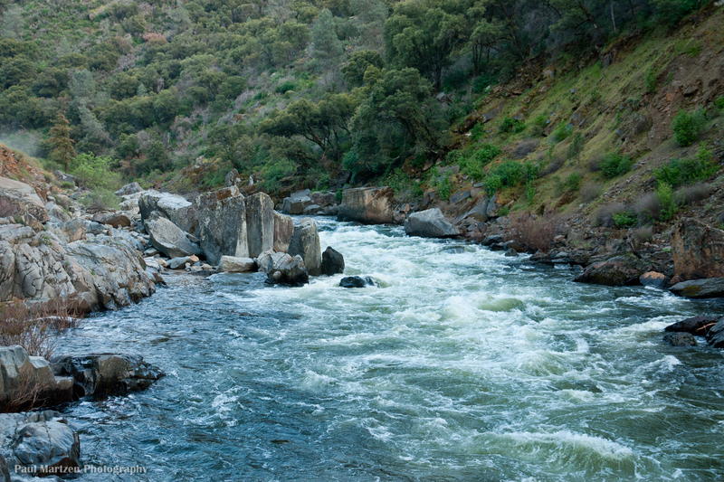
Because State Hwy 140 goes essentially continuously along the bank of the Merced, one can take-out and put-in almost anywhere that the berry bushes and poison oak allow. This means that, flow levels allowing, one can choose as easy or hard, and long or short, a day as one wants, from scary expert stuff higher up to a great novice run in the miles above Briceburg and below. The Gauge Hole just upstream from the Slate Creek Bridge (approx. 3.5 miles above Briceburg, 10+ miles below Red Bud, actually Feliciano Creek on the topo maps) is a great park-and-play spot at any flow above about 600 cfs or so on the Briceburg gauge.
The Main/Central Fork of the Merced River is one of the originally designated federal Wild and Scenic Rivers. Curiously enough in light of this, the majority of the river segment in this reach has essentially 100% man-made banks on both sides. The river-left bank is defined by Hwy 140; river-right is the remains of the old Yosemite Railroad bed. This 'man-made bank' is primarily manifested by a great amount of artificial (boulder and cement slurry)stabilization on the highway bank by CalTrans, and some 'rerouting' of the river's course, most notably in the section above the Foresta Bridge (Red Bud). Surprisingly and thankfully, the road is not particularly visible from the river level, and is not as intrusive as it could be. There is still a plentiful supply of drive-by spectators. The railroad bed is eroding away and not a big visual issue at all any more.
The Merced is steepest and most difficult on its upstream end, leading up into Yosemite National Park where paddling is banned/illegal except for a short flat segment in the midde of Yosemite Valley, per the Park Superintendent's decree; ask and I'll answer questions honestly and as best I can based on more experience than I should have, but this is outside the boundries of this reach. As one goes downstream from Parkline and El Portal, the difficulty decreases very gradually in general. Until one gets below Briceburg (14 miles downstream from Red Bud), the Merced drops very steadily without the 'pool and drop' features of many other Sierra rivers.
In the upper portions, especially at moderate to higher flows, the rapids can be very long and close together, making sections where one can swim for literally a mile or more through multiple rapids; I have first hand knowledge of this, having learned to kayak on this river. This can be true lower down as well, as the banks can be full of vegetation 'strainers' for extended lengths even in the easier sections downstream. I have spoken with more than a few paddlers who have stated that the Merced could be referred to as 'Class 3/4 with Class 5/6 consequences' because of it's continuous nature in the upper parts.
Other nuisances and hazards can include: rattlesnakes, lots of poison oak throughout, floating snag trees - both natural and man-caused by locals and emergency winter road clearing work.
FORESTA BRIDGE,AKA RED BUD, TO THE INDIAN FLAT PICNIC AREA.
This is a relatively short section, with long, continuous Class 3 and 3+ sections, and at least two Class 4 rapids, Nightmare Island and Chipped Tooth. Both Class 4s are across Hwy 140 from an obvious CalTrans gravel pit, at the end of a 1/2+ mile straight and long Class 3 beginning just below the put-in. Post '97 flood, Nightmare Island changed, and the left side route may only be 3+/4-. The right side is a constricted channel with a couple of very rocky drops and reversals; there is some real possibility of hitting hidden rocks at most levels. At higher flows, above 4000 cfs or so, Nightmare runs into Chipped Tooth and they can essentially become one rapid. *At these higher flows, the boulder sieve that forms Chipped Tooth should be a serious consideration is swimming is possible anywhere in these two rapids*
Both Nightmare Island and Chipped Tooth can be scouted from Hwy 140; park in the Gravel Pit turnout and watch out for maniacs in cars when crossing the street. If considering the right side of Nightmare Island (worth doing if you are justifiably confident of your abilities at this difficulty level), scout if from the island or from the Foresta Road across the river from Hwy 140.
The right side of Chipped Tooth seems moderately easier than the right \[highly subjective, I admit\]; at low-moderate flows, it can be eddy-hopped down small right bank eddys up to the steep boulder pour-throughs; at moderate-higher flows, this route still works to paddle through if you can't or don't hit the narrow bank eddys. The left side goes as well at most flows, but the sudden large left-right 'reversals' - waves, not holes - towards the bottom can be hard to manage.
*BEWARE - the largest drop and the 'Chipped Tooth' is formed by a group of large boulders going across the river bed, with very real sieve/trap potential if one were out of the boat or in a bad position at most flows.*
In 1999(?) a local paddler and friend in a relatively small boat missed the boof over the middle; he penciled, and found himself pinned flat, still in his boat, at the bottom of the river. He escaped barely, and spent the next day and a half retrieving his boat via high line and hook-and-pole.
Downstream another mile or more, watch for a power transformer station river left and across the road. Beyond this, and just where the river left bank joins the road again, is an old red wooden house on river right. This is the site of Red House Hole, a good play spot at most flows. Another 1/3 mile brings you to Indian Flat Picnic Area, a former camping spot now paved, outhoused, and developed by the USFS and BLM as a commercial raft put-in point. By early afternoon mid-season, it is clear of the rafters.
INDIAN FLAT PICNIC AREA TO SAVAGE'S TRADING POST AND THE CONFLUENCE OF THE SOUTH FORK MERCED
Except for the times of day when in peak use by commercial raft companys as a put in, this can be a good starting point. Parking is limited, as is driving and turning space in general, so please be considerate of the big guys. Their options are much less limited than for the rest of us, and kayakers expecially can put in almost anywhere there is enough shoulder to park on. A short distance downstream is the first real, and hardest, rapid on this segment.
Pre '97 flood, Hotel Hole was one of the Merced's legendary too-much-fun spots. My contention is that it really doesn't exist any more, at least in anything resembling the thing I did vertical 360-degree loops in open breathable air inside it on a boogie-board. It now is a long steep narrow 'sluice' entered after a quick left-right turn, having been re-engineered on river left by CalTrans in spring of '97. There are kayak eddys on the sides until we see high flow levels, and a very fine large angled wave towards the bottom on the right. This wave is responsible for some most excellent aerial action for all sizes of craft at moderate/high flows, with good spectator and recovery pools just below.
The next several miles include many entertaining Class 3 (give or take) rapids of varying lengths, including things like the Can Opener and the Percolater. Recovery pools or flat sections get more common as one progresses downstream. Several good play spots can be found along the way, as well. Another convenient landmark with a surprising amount of parking is at Savage's Trading Post. This is spotted easily by the portable outhouse trailer, and a good supply of parked cars left by hikers enjoying the wildflowers on the Hite's Cove hiking trail leading up behind Savage's. If full, there is parking and easy river access just downstream of Savage's and the S.Fork Bridge.
SOUTH FORK MERCED TO MILLER'S LANDING aka 'SWINGING BRIDGE' (the old Suspension Bridge, destroyed by flood water in Jan. 1997).
THIS IS THE LOW WATER EARLY/LATE SEASON RUN! It can be run without portage or too much rock abuse when the Briceburg Flow Gauge reads 330 cfs or higher. I usually paddle past Miller's Landing at low water, and take out a few rapids downstream or go to Gauge Hole; see 'Miller's to Briceburg.' This section has a bit of flat paddling at low-moderate flows, several very good Class 3 sections, Ned's Gulch - the 'standard' for Class 4 difficulty in these parts according to AWA's 'example' list, and several good play spots.
At the end of the first long straight rapid, the river rejoins the road and turns to the right. At most flows, there is a long wave train just beyond the bend with good large eddys river right and downstream. These waves can be some of the best wave surfing on the Merced; they need approx. 1000 cfs to start to form up and are good for several thousand cfs beyond that. 1/4 mile downstream on river left is a large beach used by locals for picnic/partying, nude sunbathing, etc. It is relatively hidden from the highway, but easy to spot as it is a steel guardrail on the river side of a large sweeping turn (to the right going uphill), marked as '30 mile an hour' turn and with signs on both sides of the road warning about parking facing opposing traffic.
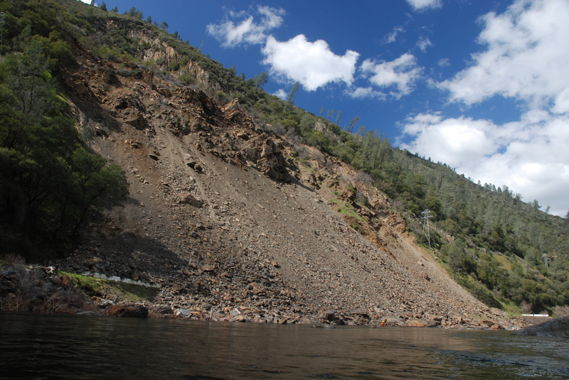
WARNING! Ferguson Rockslide
David Greenwood—BLM River Ranger reports:
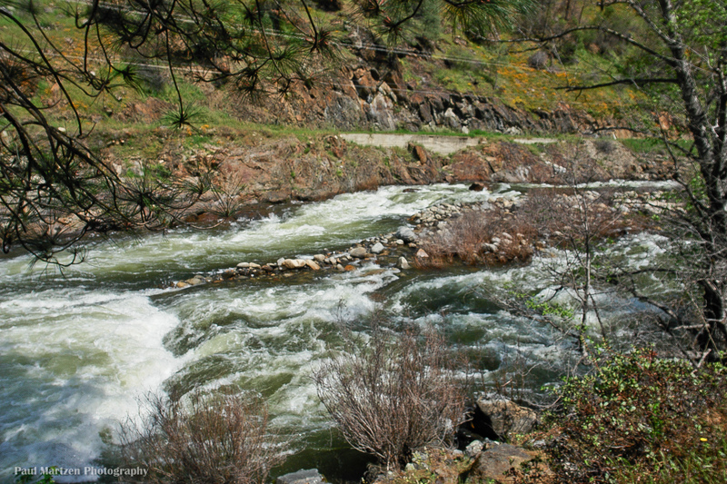
In April of 2006, a large-scale rock slide completely buried a few hundred yards of HW 140. Talus from the slide protrudes more than ten feet into the river at Balls to the Wall Rapid (about 1 mile downstream from the South Fork). The main channel is significantly constricted and many new boulders now choke the entrance to the old Balls Rapid. As flows increase there is potential for a near-river-wide hole. Likewise, as flows increase, a sneak channel opens up on the far right. Take a look at it from the road while setting your shuttle, but do not stop anywhere along the HW 140 detour, as this is a one—lane traffic control area. Scout the rapid at river level from the right bank. Stay away from river left; most of the ugly sharp junk is on that side and stray rocks are still coming down.
The Sierra National Forest has established a monitoring plan and color coded alert system. Level Green is all go. Yellow is increased caution. Level Orange may close the river to boating. Red closes the river and the highway! Check the current conditions before leaving home at http://www.fs.fed.us/r5/sierra/condi...ferguson.shtml
\[2024--Caltrans is planning on placing a rock shed through this slide area. This rapid has cleaned up after high flows of 2023, and many of the numerous, sharp rocks have moved or cleaned up. Use caution-when in doubt, scout.\]
Ferguson Slide Emergency Response Plans pdf.
Caltrans is studying several altenate methods of rebuilding the route back to a high standard. At present, buses, trucks or any vehicle over 28 feet long cannot use the detour and must enter Yosemite via Highways 120 or 41. Study plans will be posted when we find them. (Feb. 2008)
Feel free to email the River Ranger at david\_greenwood@ca.blm.gov
A few rapids and a half mile or so brings us to Balls to the Wall, a Class 3+/4- rapid. Balls has several large rocks in the middle of the river bed, then bends right, drops 6-8 ft (?) through a rocky section of 30-50 ft or so, and then turns back left sharply along a short cliff/rock section. It is somewhat tricky to stay off of the wall at the bottom; post '97 flood, the anatomical dragging that helped name the rapid in the upper turn/drop was lessened dramatically. There is a small eddy river right just before the wall turns back to the left that can be caught; surfing out of this and then turning downstream is one means of avoiding the wall. Balls to the Wall may be a bit easier than it used to be, but BE FOREWARNED!
*WARNING - THERE ARE A COUPLE OF VERY NASTY ROCKS HIDDEN IN THE WAVE TRAIN ALONG THE WALL AT LOW/MODERATE FLOWS.* There have been a lot of people including myself that have flipped and swam or rolled or just hung amd missed. There have also been a couple of the worst kayak wrecks that have ever made me sick to my stomach to watch; luckily, no permanent injuries, but a fair amount of blood and bruises, broken paddles, etc. Please believe - you do not want to see anyone's boat upside down and then levitate straight up several feet for no apparent wave/reason.
At the downstream end of Balls to the Wall are bank eddys on both sides that can be used to catch another (actually a couple, if you look close) of large surfing waves that are as good as any on any river at the right flows. The right flows seem to be around 1500 - 5000+ cfs.
The river channel changes noticeably at this point and for the next mile or so, becoming a tighter channel with folded granitic gneiss bedrock walls on both banks. Where it opens out very noticeably to the right with an occupied house and working mine, you have come to Ned's Gulch, the 'standard/example' for a Class Four (at around 4000 cfs) rapid. There is a large eddy to the right, and it is easy to scout or portage on the right along the river.
Ned's Gulch is a long set of turmultous waves/holes and a couple of drops towards the bottom, ending in a large wave train and a good run-out. The rapid bends around in a left hand turn, and can push quite hard to the right; staying off the right hand wall or out of the 'challenging' eddys on that side can be quite a chore but needs to be done for almost all but the most skilled. Many lines are possible, some better than others depending upon the flow level and skill of the paddler. The general best idea/line seems to be to start left of center, go right of center around the largest rock sticking up in the middle about 2/3 of the way down (you get pushed that way anyway), and finish by paddling as far to the left as possible while not loosing your bow angle downstream. The game is to stay off the right hand wall at the bottom - doesn't seem to hurt anyone, but makes it hard to stay upright at the final drop into the wave train.
*A Caution at low flows, below 600-700 cfs, maybe higher -* The bottom drop on the right side has several hidden rocks at the bottom of it. They can be pitoned most uncomfortably, and otherwise be in the way. It is really important to work back to the left after rounding the large rock towards the bottom at these lower flows. If all else fails, boof with all you got.
Below Ned's, there is nothing harder than Class 3 until well below Briceburg. Approx. 1/4 mile below Ned's, at the end of a gentle right turn, a series of very sharp rocks (rafts have been Hindenberged here)with an island river right just upstream at low/moderate flows. The island goes to either side, the easier run is to the right. To the left can take some quick maneuvering, and work to avoid the left wall at the bottom. Doesn't look like much, but can sneak up and slash you. At higher flows, the largest rocks get buried inside some large green-water waves; wave crashing can bite back here.
Beyond this rapid, there are a few more class 2+/3- rapids, and some relatively flat spots. Approx. 3/4 mile below Ned's, you'll see in the distance on river right an old miners camp and cement plant marking Miller's Landing. The rapid here is straight with a few significant holes at larger flows, but in general a fun series of haystacks and called the 'Rodeo Rapid' by some locals. At the end is a beach and river access with a good amount of parking. This is a good take-out, or one can continue down. Note that there are owners of Miller's Landing occasionally in residence, using a wire rope bridge with hanging pull-car to cross the river. They seem generally unfriendly, and have a local reputation for persecuting trespassers - it is posted no trespassing. The other distinctive feature at this point (not that you can miss the large white 2-3 story buildings) is the remnants of a wooden one-lane suspension bridge that was the primary land-mark for this site until destroyed in Jan. of 1997.
MILLER'S LANDING \[aka SWINGING BRIDGE\] TO BRICEBURG
This is what passes for the local 'beginner/learning' run; for really inexperienced parties or those without at least one strong rescuer/paddler, it might be worth starting further down, especially at moderate to high flows. Nothing harder than 2+/3- until it gets high, but long swims, a lack of bank eddys, and a fair amount of brush in the water on both sides still can be had.
The put-in/tale-out spot at Miller's Landing is an obvious large rocky beach with good trail and lots of parking extneding down the road. It is used as a take out for many coming from farther upstream, such as from Indian Flat or Red Bud.
Gauge Hole, below the Sweetwater Creek Bridge and just above the Slate Creek Bridge, is a worthy destination play spot at flows above 1500 cfs. At over 8000 cfs, Gauge becomes a glassy wave with a 10-15 foot glassy wave front; it always has a good access eddy river right, and is used as a common take-out by local paddlers and those wanting to finish with a good play session. Gauge Hole is actually a combination wave-hole, formed by two flat fronted and topped rocks with a space between them just big enough to pass a kayak bow, and forming a seam and sub-surface current going out the back of the pile. At even moderate flows, this is a large steep 'keeper' wave/hole that can hold side-surfing kayakers long after they are tired and want out. At moderate to high flows, full sized rafts can be surfed here. The easiest way out if all else fails is to flip upside down, and if not washed out quickly, reach carefully (shoulders?) down/around with your paddle - the under-current will always sweep you out the back.
There is a fairly large amount of parking here on both sides of the road. Putting in and taking out kayaks directly at the hole can be done if one looks close at the rocky ramps leading down from the road. An easier takout - trees/brush not withstanding - is to take out just downstream directly at the 'Slate Creek' bridge (actually Feliciano Creek on the topo maps), and going up to the road either through the grapes on the left before the bridge, or by going under the bridge on your right and then up to the road. Rattlesnakes have been seen under bridge, along with many other areas of the Merced from here down. This is also a 'decent' put-in for those on their first kayak run in moving water, or those looking for Class 1-2 only. It can still be fast and very brushy along the edges at moderate to high flows, so think/plan accordingly.
\[2024--Though the above still is true at certain flows, the glory days seem to have faded for this play spot, in general. Hopefully something will move into the magic spot again.\]
Downstream take-out on this segment is the BLM parking lot at Briceburg. When Bear creek is running on warm days, the inflow has a nice warm pool, a bit tight, but good for roll training/practice for one kayak.
BRICEBURG TO RAILROAD FLAT, the end of road access from upstream
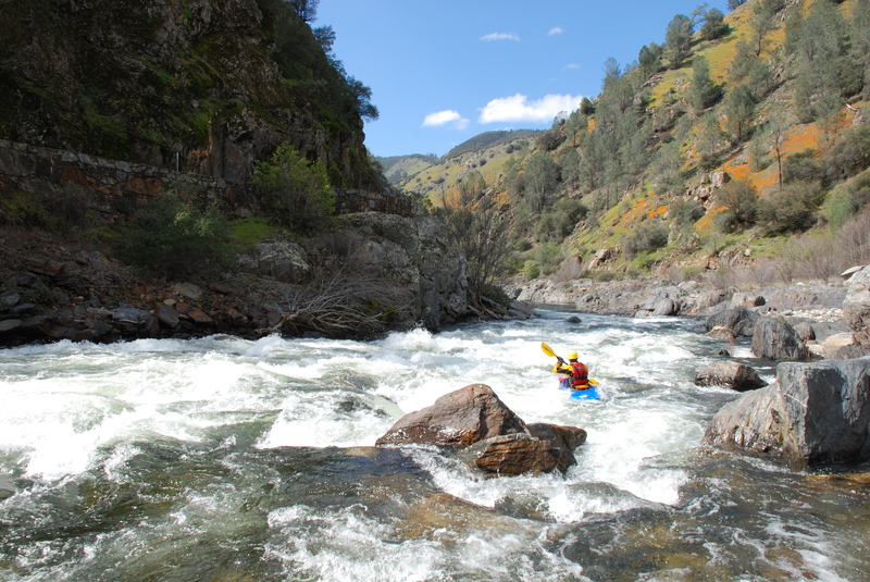
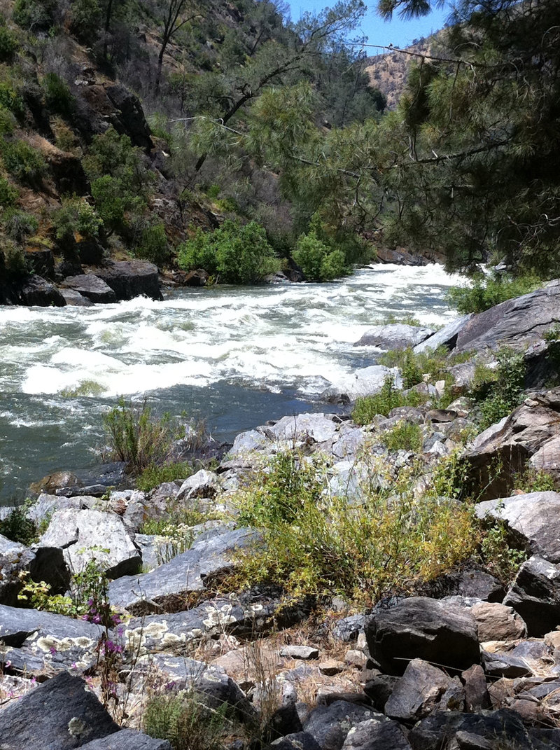
This section is very different from the Merced River upstream of this point. It still has continuous road access, but on a dirt road along the river right side. The banks are steeper with more short rocky faces, the channel is narrower, and the rapids more pool-and-drop style than the long continuous boulder fields upstream. It stays more enjoyably paddle-able at the lowest flows.
The first mile and a half or so are relatively flat, with only a couple of constrictions and/or turns forming easy (class 2+/-?) rapids. Around this point, you can see some large metal plates in the right(road) bank; on the road, there may be some large metal plates visible depending upon how much dirt is around. This is the siphon/pump station that provides the town of Mariposa with its municipal water supply, and also the site and reason for the flow gauge 'below Briceburg.' There is a good beach here at low/moderate flows.
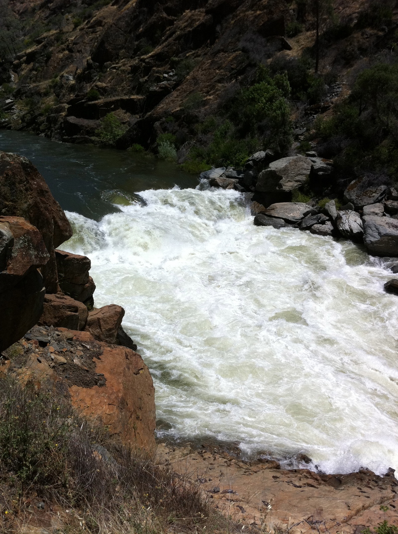
Below this point, the river starts to accelerate until it reaches a couple of class 3 rapids close to McCabe Flat. If not careful, the first of two class 4 rapids, 'Split Rock', can sneak up on the unwary. At low/moderate flows, this shouldn't be a problem as the route is pretty much straight down the middle in the tongue. At moderate/higher flows, some scary holes can form, and this rapid becomes essentially one with the next rapid, a somewhat harder (at most flows) rapid called 'Corner Pocket' for very good reason.
*Warning - at moderate to high flows, Split Rock and Corner Pocket can run together into one large and scary complex rapid. Scouting thouroughly before deciding to run this is strongly recommended, given the rocky nature of the rapids and the eddy trap at the bottom.*
Corner Pocket can be scouted and portaged at the campground on river right, McCabe Flat. It is a rocky angular pore-over several feet tall, at the bottom of a rocky lead-in. If one enters or gets pushed too far to the left, you end up in the Corner Pocket at the bottom, river left. The first time I saw this feature, I watched six kayaks follow into this like lemmings. All six ended up swimming out, with the boats tumbling in the pocket for later retrieval. The current below the pore-over splits, and the left flow goes up against a flat wall that forms a very strong recirculating eddy. Bank access on this side is not as easy as it could be, and like everything else along this reach, infested with poison oak.
Below this point, flat paddling is occasionally broken up by short class 2-3 rapids of no real notability. After 2 1/2 more miles, take out at the end of the driveable road at Railroad Flat campsite.
RAILROAD FLAT TO HWY 49 AT BAGBY
There is no road access from this point to the take out at Bagby, where the river crosses under a bridge on Hwy 49 north of Mariposa. The old railroad bed turns into a foot and mountain bike trail along the river right side. Take out at Bagby has changed hands in the past couple of years, may have been purchased by state or fed. park mgt. ageny. The precise status is unknown (other than it is available and can be used) at this time to the author; I intend to make another run down this way in the near future, and will then be able to pass on the most current info.
The first mile or two below Railroad Flat is enjoyable and acenic, if not particularly challenging. The prime feature of this section is a rapid called 'Quarter Mile.' Actualy feeling more like a half mile, it is a tighter channel with continuous pool and drop features that can be boat scouted along the way, eddy hopped and dropped with continuous amusement at low to moderate flows. At higher flows, this could prove to be a significant and ugly trap.
*Immediately - 50 ft? - at the end of Quarter Mile is an impassible Class 6 called North Fork Falls, where the North Fork of the Merced joins the Main Merced. There are several very large flat and blocky boulders that much of the river flows UNDERNEATH! If there is even the slightest chance of missing this mandatory portage, don't!*
At North Fork Falls, there is a pipe skid rig up the right side for rafter use. This is a short portage if one continues down lessening Class 2/3 rapids, and ending at the upper end of Lake McClure if the lake is full, and continuing to Bagby if the lake is low. The alternative for kayakers is to portage the 3(?) miles back up to Railroad Flat. Quarter Mile rapid is fun enough that I have endured this portage more than once and not for the last time.
THE GOVERNMENT 'RULING' AGENCIES AND RESPONSIBILITIES
As a friend and I discovered while organizing a 'first annual' river clean-up on the Merced in 2001, the concept of a 'responsible agency' is a wonderfully (literally, you can't help but wonder...)convoluted situation. Here goes my best try -
BLM claims responsibility for the waterway itself outside the boundary of Yosemite National Park at 'Parkline.' BLM also has land management responsibilities near and below Briceburg, including campgrounds and picnic areas. BLM Merced River Recreation Area
National Park Service - Yosemite NP has an 'administrative' site that makes them the effective law enforcement, fire, and emergency medical entity in El Portal, from Parkline to roughly the Foresta Bridge at Red Bud.
There are private homes periodically along the banks in the upper sections around and below El Portal. For the most part, paddlers are at least tolerated. Obviously, respect for the few driveways, etc. is a good thing. El Portal is ruled by the National Park Service (with occasional assistance from Mariposa County Sheriff's office), who owns/operates the majority of the town as an administrative site in support of Yosemite National Park. In theory and as a general rule, as in Yosemite Valley itself, in order to be a resident one must work for either the NPS-Yosemite or the private concessioner businesses in the Park or in El Portal.
The US Forest Service has two units involved. The south bank between El Portal and the BLM downstream is part of the Sierra National Forest (includes the South Fork Merced, once it leaves Yosemite NP near Wawona). The north bank between Red Bud and the BLM area, including a number of picnic/campground areas, is part of Stanislaus National Forest. Somewhat curiously here, but somehow in keeping with the theme of this governmental cluster-mix, there is a resident California State Parks presence (a man named Sam Luna) below Red Bud in the USFS campground/picnic areas.
Cal. State Hwy Patrol shares the highway with the Mariposa County Sheriff's Office and NPS Yosemite in El Portal. The Sheriff's SAR team is ultimately responsible for problems in the river; NPS El Portal/Yosemite is also involved, and usually closer.
*Thankfully in all this, -911 works well and gets the help needed once a call can be placed; note that cel phones and radios both have significant dead spots in the Merced River Canyon.*
GROCERIES, BEER, LODGING, AND CAMPING
Groceries and supplies can be purchased at the El Portal Market, a small store that has most essentials. If tolerated, one can also buy more limited supplies at Cedar Lodge and at the Yosemite View Lodge at Parkline. Both of the latter are large hotel complexes in the Merced River Canyon, owned by the same individual. In 2001, the Cedar Lodge management asked us to pass on that kayakers were no longer welcome in their parking lot or on their beach across the road. So be it, there's other places to buy beer and park/shuttle. They do have a bar and restaurant. Yosemite View Lodge or 'Parkline' does have a decent pizza, if they are open, a bar and a restaurant. The Yosemite Bug Hostel at the top of the Briceburg grade on Hwy 140 has a small restaurant with limited and usually good fair. Your best options for any real-world selection in groceries, camping supplies, restaurant fair, etc. are in Mariposa or before you leave home.
CAMPING can be had at a number of USFS and BLM primitive campgrounds/sites below Red Bud/Foresta Bridge on river right, and below Briceburg as well. All are 'first come, first served.' There are roughly 30+ BLM sites below Briceburg spread between McCabe Flat, Willow Placer, and Railroad Flat. There is a $10/night/site self-registration fee, and a limit of eight persons per site; I did not see a stay limit when checked in March 2002, but there probably is or will be one soon. Most weekends during any real flow levels will find all these areas full, especially as summer gets closer; week days have had sites usually available in past years. The commercial Indian Flat campground just up-canyon from Cedar Lodge (a whole separate business/owner) has been recommended by out-of-town paddlers/friends I've talked to.
For those willing to spend $140+/day/room (off season), Cedar Lodge and The Yosemite View Lodge at 'Parkline' (it's old name) seem to have grown big enough in the past several years to always have rooms available; I understand that the 'in season' prices, usually starting around Easter and lasting into the early fall, may go over $250/night in 2002. Both of these facilities are owned by the same local tycoon; Cedar Lodge is the spot noted where the Hotel Management asked me to pass on that kayakers were not welcome in her parking lot or on her beach across the street.
The Yosemite Bug Hostel, at the top to the Briceburg Grade on Hwy 140 heading out of the river canyon going back toward Mariposa is a growing local business with a fast growing reputation for good food, friendly and inexpensive accomodations in several configurations - cabin, bunkhouse, tent sites, etc. There are other options in and outside Mariposa.
YOSEMITE NATIONAL PARK
Camping and staying inside Yosemite National Park can be expensive, frustrating to arrange, and a real hassle unless one really wants to plan their trip for this well in advance. Check the various park websites for details, listed below in no particular order of desirability, even though I do get paid by at least two of them. Also, a head's up if you don't frequent the National Parks System - the entrance fee, good for 7 days, is $20.00/car. These fees are now retained by the Park management and used to fund a number (albeit usually controversial at some level) of long overdue park infrastructure improvements. If you've never been and seen John Muir's second favorite big hole in the ground, do so if there's any way possible. I came here for a few months many years ago, and so may be a little on the prejudice side. The scenery here continues to be mind-blowing, even having lived on the Valley floor for years!
\-- Yosemite Guides: (877) 425-3366, a relatively new commercial interpretive and activity guiding service based out of the Yosemite View Lodge in El Portal. Yosemite Guides.
\-- Yosemite Association: Outdoor seminars and classes, and a non-profit supporter of various Yosemite National Park projects and functions (209) 379- 2321, Yosemite Association. The Yosemite Association also maintains these Live Webcams in Yosemite park.
\-- Yosemite Institute: Field trips and seminars,youth/school programs, interpretive summer programs for all ages. (209) 379-9511 or Yosemite Institute.
\-- Southern Yosemite Mountain Guides: Private guiding service, options in and around the park, (800) 231-4575, Southern Yosemite Mt Guides.
\-- National Park Service - Yosemite: You receive a schedule of ranger-led natural-history talks/walks at the entrance station when they take your $20 entrance fee, (209) 375-9505, NPS Yosemite.
\-- General: Road and weather, (209) 372-0200.
Yosemite Concession Services Corporation: in-Park lodging, dining, retail, recreational opportunities, Yosemite Mountain Guides/School (559) 252-4848 or YCS.
Yosemite In-Park campgrounds: (800) 436-7275, or Yosemite Campgrounds.
Information on adjacent areas, Highway 120 Chamber of Commerce, (800) 449-9120.
Yosemite Bug Hostel in Midpines, (209) 966-6666, or Yosemite Bug Hostel.
National Wild & Scenic River
The Merced is part of the National Wild & Scenic Rivers system. The included sections are from the headwaters of the main fork all the way to elevation 867 feet which is the high water mark of Lake McLure. The entire South Fork Merced is also included.
Other Information Sources
Cacreeks.com
BLM Merced page.
Merced River Watershed Portal
Cassady & Calhoun, Holbek & Stanley, Martin, Penny
Rapids in this Run (12)
Rapid
IV
Chipped Tooth
 Rapid
Rapid
Indian Flat
 Rapid
Rapid
Savage's Trading Post, South Fork Confluence
 Rapid
III+
Rapid
III+
Ferguson Rock Slide
 Rapid
IV
Rapid
IV
Ned's Gulch
Rapid
Briceburg
 Rapid
IV
Rapid
IV
Split Rock
Rapid
IV
Corner Pocket
 Rapid
IV
Rapid
IV
Quarter Mile Rapid
Rapid
Proposed Max Reservoir Elevation
Rapid
FERC boundary for Merced Project
Rapid
Reservoir Max Elevation
Waterfalls (1)
Hazards & Portages (2)
Caution: The following locations may require scouting or portaging. Always check current conditions.
Difficulty
Class IV
Length
14.3 mi
Gradient
40 ft/mi
max 120
Rapids
12
2 Hazards
Access Points
Difficulty Classes
I Easy
II Novice
III Intermediate
IV Advanced
V Expert/Extreme
VI Unrunnable
Current Conditions
5-Day Forecast
Whitewater data from
American Whitewater
American Whitewater