Aziscohos Dam to Wilsons Mills
Linked via: Proximity 95% confidence Synced 6mo ago
Gauge Conditions
Runnable: ? – ? CFS
Approximate reading: This gauge is 5.4 miles away on Magalloway. Use as a general reference only.
Data from American Whitewater & USGS
Run Map
Description
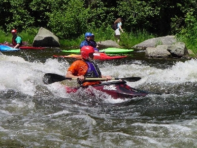
The upper portion of this run is a technical class V with vertical drops up to 18'. Some rebar, concrete, and old log cribbing can still be found here complicating some of the obvious clean lines. The easier (and more popular) class III section of this river can be accessed from a parking lot by a power plant about 1/2 mile south of the route 16 bridge over the river. Look for a dirt road between high banked dirt burns leading down to the access parking lot. At the parking lot hike down a trail that leads below the last of the class IV-V drops and put in here. From here the river is a technical class III through a boulder strewn rapid. Look out for pinning boulders. About a 1/2 mile down river there is a nice surfing wave formed at a ledge outcropping. More class II-III water continues with a few more difficult sections at rock ledges with large hydraulics to avoid. Take out downstream river right at the route 16 bridge overpass.
### Technical info
```
Put in elevation........1356' (1445Â Class V section)
Take out elevation......1256'
Total drop..............100' class III section, 89Â class V section
Average drop/mile.......67 ' class III section, 178Â class V section
Distance................1.5 miles (class III section);
2.0 including class IV-V section
River width average.....70'
River geology...........medium granite boulders and ledge
River water quality.....Good, clarity good.
Scenery.................Good to excellent,
Wildlife................Deer, moose, hawks, eagles.
```
Rapids in this Run (1)
Playspots (1)
Difficulty
Class II-III(V)
Length
2.1 mi
Gradient
67 ft/mi
max 178
Rapids
1
Access Points
Difficulty Classes
I Easy
II Novice
III Intermediate
IV Advanced
V Expert/Extreme
VI Unrunnable
Current Conditions
5-Day Forecast
Whitewater data from
American Whitewater
American Whitewater