Baker Pond to Wentworth
Linked via: Nhdplus discovery 90% confidence Synced 3mo ago
Gauge Conditions
Runnable: 3.0 – 10.7 FT
Upper limit for best boatability uncertain. Please help your fellow boaters with a comment or report.
Data from American Whitewater & USGS
Run Map
Description
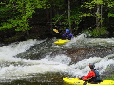
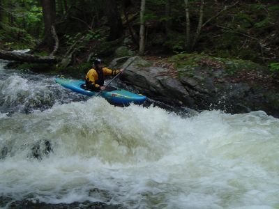
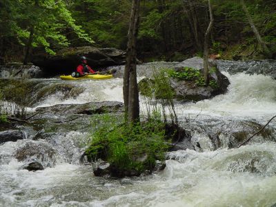
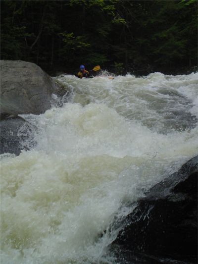
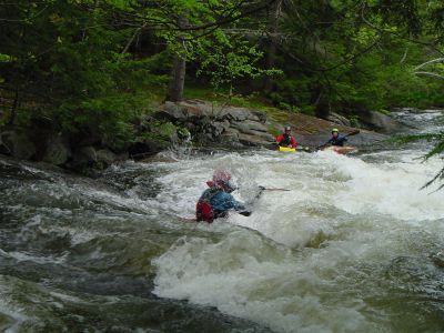
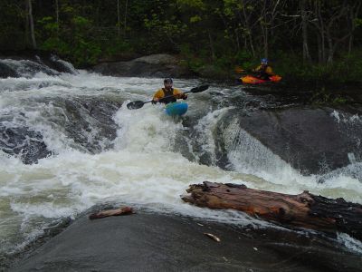
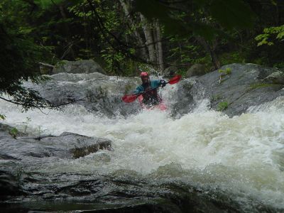
Pond Brook is a very narrow steep creek. The river starts out class III then eases somewhat through a swampy area. The action picks up at about the 1 mile mark then quickly starts to build up to continuous class IV and V. It's geology is somewhat unusual for New England, it has a lot of ledgy type drops of 2' to 3' spaced closely to each other. One drop runs over a granite slide that drops approximately 30' over a 100' distance. Some of the river can be scouted from state route 25A which runs along the run but many drops are out of view from the road.
Pond Brook is located in the Upper Baker River valley about 16 miles west of Plymouth.
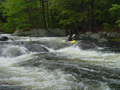
It is a relatively small river that drains Lower Baker Pond. The river itself starts at the dam at Lower Baker Pond. There is good warmup rapids for the first half mile but you must portage around a low snowmobile bridge then contend with some flat water. For this reason most paddlers chose to put in ½ mile further downstream where NH 25A comes close to the river. At this point the river is flat and running through an open marsh. Shortly after the river enters the forest class II-III rapids begin. The most significant factors in this section are tree falls and strainers. Boat scout each drop carefully to avoid problems. The action picks up about a mile and half below Lower Baker Pond. Some class III ledge drops start appearing the first of which is "Roadside". More small ledge drops continue until they start to pick up in intensity just after the 2 mile mark. The remaining mile of river contains the largest and most intense rapids. It is mostly away from the road but never more than a quarter mile. Starting at Z-chute there is evidence of river modifications for mills built in the 19th century. These mills are long gone but the rock work is evident all the way to the last rapid.
Posted by Dan Holzman on the MVP message board 3/30/03
Pond Brook has some outstanding ledges, very photogenic, ends with a totally sweet set of slides and a 10 foot waterfall (built in boof ledge, note to self, get back there soon before water runs out, gotta run those ledges).
Beta on Pond Brook: there is a low snowmobile bridge or similar about 1 mile downstream of the put-in at the dam, mandatory portage. There is a log across the river in the first big drop about 1.2 miles downstream, MANDATORY portage, don't miss the eddy above this drop. Lessel's book makes this sound like a death creek, it isn't, the group ran all the drops with no major issues, however watch for lumber (as usual on creeks), and try not to hit your head (ditto).
### Technical info
```
Put in elevation........885'
Take out elevation......557'
Total drop..............328'
Average drop/mile.......110'
1st mile................26'
2nd mile................159'
3rd mile................143'
Distance................3.0 miles
River width average.....18'
River geology...........Granite ledge, small to medium boulders
River water quality.....Excellent, clarity good to excellent.
Scenery.................Good mountain scenery, route 25a occasionally visible
on river left.
Wildlife................Deer, moose, hawks.
```
## Directions
### Put in
From southern NH
Take interstate 93 to exit 26 (Tenney mtn highway rt 25)
16 miles to Wentworth NH
Take a left on NH 25A
2.5 miles to where the river comes in close on the left. This is the first option put in. You can continue another 1/3 mile to Lower Baker Dam for the short warm up. The first option put in has limited parking just make sure you pull well off the road.
### Put in
From Vermont
Take interstate 91
Take EXIT 15 toward US-5 / FAIRLEE / ORFORD N.H
Turn RIGHT onto LAKE MOREY RD.
Turn LEFT onto US-5
Turn RIGHT onto BRIDGE ST / VT-25A. Continue to follow VT-25A (Crossing into NEW HAMPSHIRE).
Turn LEFT onto BAKERS POND RD / NH-25A. Continue to follow NH-25A 13 miles to the Lower Baker Pond put in or continue another 1/3 mile to the roadside put in.
### Take out
Head back to Wentworth and take a right on NH route 25.
Take a right on Ellsworth Lane road.
Park near the bridge at Back Yard rapid.
If you have many vehicles to park continue south on 25 over the Baker River Bridge then take a right onto the town ball field parking area close to the river.
Rapid Naming Convention
It is not the intention of the author to name rapids for his own personal ego. Every effort was made to find the current, historical, or conventional name for each rapid. Unfortunately, Pond Brook is not run very often and paddlers have not named even the toughest sections. Historical records and maps do not have any information. Names assigned on this page and associated map were given by the author. Those names are mostly generic and are given to identify a unique feature (i.e. Z-chute) or location (i.e. Powerline) prevalent on or near the rapid. If in the future the traditional name is uncovered or paddlers begin to accept a new name, the author will attempt to change those names to correspond with the accepted norm.
Difficulty
Class IV-V
Length
3.1 mi
Gradient
110 ft/mi
max 180
Rapids
9
Access Points
Difficulty Classes
I Easy
II Novice
III Intermediate
IV Advanced
V Expert/Extreme
VI Unrunnable
Current Conditions
5-Day Forecast
Whitewater data from
American Whitewater
American Whitewater