Balch Afterbay to confluence with Dinkey Creek
Linked via: Nhdplus discovery 90% confidence Synced 6mo ago
Gauge Conditions
Runnable: ? – ? CFS
Approximate reading: This gauge is 18.1 miles away on Kings. Use as a general reference only.
Data from American Whitewater & USGS
CDEC Flow Data California
Data from California Data Exchange Center (CDEC)
Run Map
Run Time Estimate
Select put-in and take-out to estimate time.
Unlock Advanced Trip Planning
See wind-adjusted speed maps, forecast planning, and detailed time estimates.
Sign in to generate an AI timing estimate for this run.
Whitewater timing varies with scouting, portages, and group pace. Use as a planning baseline.
Description
This is a super little section that is easiest to catch with flow in January or February when PG&E does maintanence on a downstream powerhouse. It can also flow at a reasonable level in the spring of a big water year.
Take-out is in Balch Camp at the confluence with Dinkey Creek. Most boaters will continue on down the NF Kings to the confluence with the main Kings.
Put-in: Drive up a paved road on the south side of the river towards Balch Dam. Just before the dam, there is a wide spot and a steep slope and gulley leading down to the river. It is loose and awkward and steepest just above the water. Consider lowering your boats with ropes. Alternatively, go a few feet past the gulley to a clean cliff dropping straight to the water. There are huge bolts in the wall on the left side of the road for anchors. The cliff looks around 200 feet high and the landing at the bottom is large enough to accomodate several boats and people. Rappelling and lowering down this cliff might be quicker and safer than going down the gulley.
Once on the water, you get a few eddies and a very short ways to warm up before the creek drops down several long steep rapids. Watch for logs! You can scout or portage, but it is very awkward because of thick vegetation.
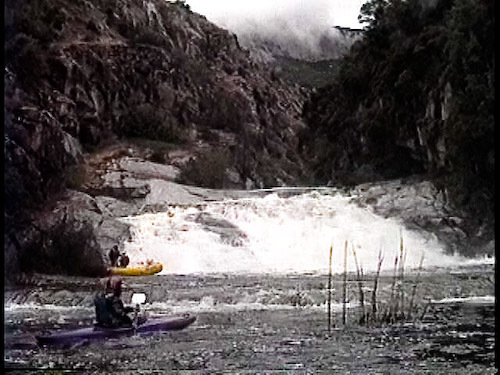
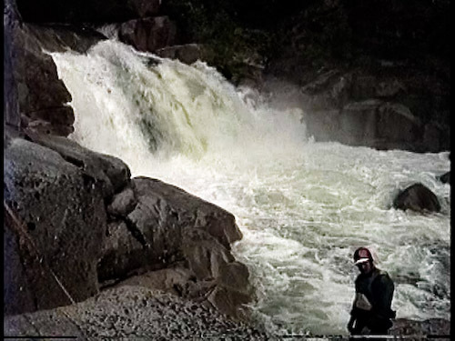
The initial rapids end at a pool above a 25' (approximately) waterfall. It may be runnable and it does drop into a short pool.
Immediately below is a steep sliding cascade with a congested exit. I portage on the right, then cross the small pool to the left and finish climbing down on the left side. The portage is much easier on the right except that it is very difficult to relaunch into the river on that side. Check it out and decide for yourself.
After the portage, one immediately enters a short but pretty gorge with vertical walls. There is only one ledge drop in the middle, otherwise it is flat.
Peering downstream through the gorge though, you will see the tops of pine trees. The horizon line at the exit is the top of a 30 foot high two tiered slide. Lots of fun, but also easy to portage on the left.
Several smaller slides follow, before the gradient eases and the character changes back to long, rocky, narrow rapids. The rapids are tight and interesting all the way to the confluence. Logs and trees may be a problem in any section, but seem to be worse at the end just above the confluence. Looking upriver from the bridge in Balch Camp, one sees the creek spread out and running through a grove of trees, but fortunately that is not characteristic of the rest of the run.
To catch this run, you need spill from Balch Dam, controlled by PG&E. In big water years upstream reservoirs (Wishon and Courtwright) spill, but send down too much water for this run. For a few weeks before the main spill however, Balch may start spilling with flow from tributaries below Wishon Reservoir. You only want a few hundred cfs.
The other way I have caught this run is when PG&E is doing maintanence on the Kings River powerhouse and is not finished before they need to send water down. In January or February, watch the gauge for the NF Kings below Dinkey Creek . Normally all of this water comes out of Dinkey. If you see a sudden odd elevation of the flow for several hours followed by a sudden drop back to normal, it is likely that the dam is spilling for that time, while upstream powerhouses are running.
The Balch Power Project is licensed as FERC No 175. It goes through the relicensing process every 40 - 50 years, most recently in 2022 - 2024. It is still in the licensing process as of Feb 2024. Documents are available at http://www.balchrelicensing.com/ and at PERC's eLibrary at https://www.ferc.gov/docs-filing/elibrary.asp where you will have to search for FERC project #175.
Paul Martzen
Fresno, CA
Rapids in this Run (1)
Waterfalls (1)
Difficulty
Class V
Length
1.6 mi
Gradient
130 ft/mi
Rapids
1
Access Points
Shuttle Info
From Fresno it is about an hour to an hour and a half to Balch Camp which is the take out. It is only a few minutes further to the put in.
Difficulty Classes
I Easy
II Novice
III Intermediate
IV Advanced
V Expert/Extreme
VI Unrunnable
Current Conditions
5-Day Forecast
Whitewater data from
American Whitewater
American Whitewater