Beaver Slide Road to Nehalem River
Linked via: Proximity 98% confidence Synced 6mo ago
Gauge Conditions
Runnable: 500.0 – 2,500.0 CFS
ELF boating has been done in this range.
Data from American Whitewater & USGS
Run Map
Run Time Estimate
Select put-in and take-out to estimate time.
Unlock Advanced Trip Planning
See wind-adjusted speed maps, forecast planning, and detailed time estimates.
Sign in to generate an AI timing estimate for this run.
Whitewater timing varies with scouting, portages, and group pace. Use as a planning baseline.
Description
The Salmonberry River is an approximately 10 mile whitewater run that is known for its great rapids, beautiful scenery, excellent water quality, and remote backcountry character.
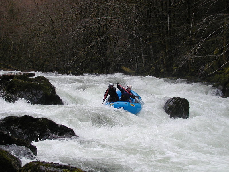
Mention the Salmonberry and paddlers start to buzz quietly like bees. This is one that alludes many paddlers due to the need for a high water/rain event, combined with the rugged road to the put-in making the shuttle logistics an adventure in itself. Four wheel drive, high clearance, and good directions are key just to make it to the put-in.
Once at the river, paddlers are in for a treat. The lichen-covered trees provide classic northern Oregon Coast range scenery while the rapids provide continuous entertainment.
Chew Chew (class IV) is the most challenging rapid on the run. Chew-Chew(Class 4), is about 0.5 miles downstream just after Bathtub Creek enters on the left. Chew-Chew begins with a steep drop over some boulders and finishes with a few pushy waves and holes. Most people choose to punch several holes on the far left or boof the large boulder in the center. Scout/portage on the right. Our group scouted/portaged from the left, and most of the group ran the left line.
Below Chew-Chew the river continues through several fun Class 3-3+ rapids until it gradually flattens out. There are some great views of the canyon in this section. The rapids pick up again as boaters approach the take-out. Take-out under the road bridge on river-right or farther downstream on the right at the railroad bridge.
It is remarkable (and somewhat terrifying) to see the railroad running along the river's edge and, at times, falling into the river bed. A historic treasure along the river!
Rapids in this Run (1)
Difficulty
Class III+(IV)
Length
10.4 mi
Gradient
70 ft/mi
Rapids
1
Access Points
Shuttle Info
To reach the put-in, take Salmonberry Road south from Hwy. 26. Salmonberry Road is about 0.5 miles west of milepost 30. Stay straight at the 4-way intersection about 1.2 miles from Hwy. 26. Turn left at the sharp turn about 4.4 miles from the highway. Turn left at the 3-way intersection just over 8.5 miles from the highway and after about a mile begin the long descent to the river down Beaver Slide Road.
The take-out is along the Nehalem River road at the Salmonberry confluence. Turn south about 0.75 miles west of milepost 21 on Hwy. 26 and continue south along the river to the bridge over the Salmonberry River.
Difficulty Classes
I Easy
II Novice
III Intermediate
IV Advanced
V Expert/Extreme
VI Unrunnable
Current Conditions
5-Day Forecast
Whitewater data from
American Whitewater
American Whitewater