Bonniwell Road to Highland Road (1.2 - 2.4 miles)
Pigeon Creek
Linked via: Unknown Synced 6mo ago
Gauge Conditions
Runnable: 200.0 – 800.0 CFS
Almost certainly too low. (~0-50 cfs)
Data from American Whitewater & USGS
Run Map
Run Time Estimate
Select put-in and take-out to estimate time.
Unlock Advanced Trip Planning
See wind-adjusted speed maps, forecast planning, and detailed time estimates.
Sign in to generate an AI timing estimate for this run.
Whitewater timing varies with scouting, portages, and group pace. Use as a planning baseline.
Description
Quick Facts
Location: A mile north of Thiensville, 3.3 miles south of Cedarburg.
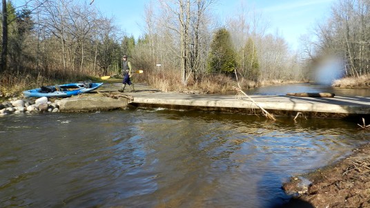
Put-in: 43.2653, -88.0137 (8340 W.Bonniwell Road, Mequon)
Take-out parking: Highland Woods, Green Bay Road, Mequon
Shuttle:: 2.7 miles/5 minutes
Put-in is approximately 792' elevation.
Take-out is approximately 669' elevation.
Thus total elevation change is approximately 123'.
Gradient Average: approximately 50 FPM.
IMPORTANT NOTE: Gradient values should be used for general comparative purposes only! Differences (even up to 15-20% and more) mean very little in the grand scheme of whitewater! (Streams with gradients in excesss of 50 FPM may be swiftwater with no meaningful rapids!)
Class/rating can also mean relatively little. Short, not overly complex rapids may be rated as III or IV (or even V), and may be run by inexperienced boaters without serious mishap! Conversely, there are complex, technical class II boulder-garden rapids which often cause upsets, injuries and even death among inexperienced boaters! Never rely solely on class/rating to decide if you should run a river/rapids!
Far more important than either gradient or class/rating are other less-quantifiable 'character factors' such as: (1) continuous versus pool/drop, (2) wide-channel with multiple routes versus narrow channel with essentially one route, (3) straight-shot routes versus complex technical maneuvering-required routes, (4) gradual river banks versus rocky shores or steep-walled gorges, (5) heavily wooded (prone to strainers, sweepers, deadfall) versus just shrubs, grasslands, or non-vegetated surroundings, et cetera.
Character: Extremely narrow meandering rural stream with deadfalls, snags, shallow braided channels, impassible culverts (and some passable ones), electric fences, and areas of bedrock slides. Recommended only for true masochists with solid boating skills!
River banks: Almost entirely low river banks, VERY filled with trees and shrubbery.
Typical width: 8'-30' (exclusive of flatwater pools/lakes)
Drainage area at put-in: 3.5 square miles
Drainage area at take-out: 9.8 square miles
Drainage increase: 180%
Access Issues
Mequon has an ordinance saying it is _'unlawful for any person to: park, stop or leave standing any vehicle, whether attended or unattended, upon any street or highway of this city'_. (Passing drivers have stopped to tell me this when I have just stepped out of the car to briefly LOOK at the creek!) Leave a car anyplace not specifically marked for parking and you are very likely to be ticketed, and possibly towed/impounded! The ordinance also affirms that it is (unlawful for any person to:) _'park on private property without the expressed consent or permission of the property owner;'_ (Which is always the case, anywhere, anytime, making it odd that they felt a need to codify that!)
It would be advantageous if one could access to this stream from somewhere along Hawthorne Road (for scouting this area before putting on, and/or possible alternative put-in). However, Hawthorne Road is (as is Bonniwell Road) narrow, with nonexistent shoulders even if it were legal to park along them. Thus, it would be necessary to drive up someone's driveway, hope someone was home, and ask for permission to leave a car in their driveway while you ran the river, and then you would need to carry thru their yard to get to the creek. That is far more intrusive than I prefer to be.
At our listed put-in, parking is available right near the creek in a secondary, gravel drive. It is still necessary to knock on the door at the nearby house to seek permission, but you are not leaving a vehicle in a primary driveway, and not walking through a lawn to access the creek. (If you don't find anyone home (or won't even try), move on ... you do not have permission to park here!)
The listed take-out is where (adjacent to each other) the creek, the 'Ozaukee Interurban Trail', and a railroad all cross Highland Road. This is a highly visible location, being about 100 yards from a stoplight-controlled intersection (Cedarburg Road / Hwy.57). Though a few people have suggested they've done so with no ticket, there is no marked parking here. The nearest legal parking would be the lot for Highland Woods (on Green Bay Road just south of Highland Road, about a 0.42 mile carry from the take-out).
General Overview
This lies solidly in the vein of 'micro creeks', novelty runs, and 'stupid boater tricks' ... it is likely to test the limits on how small a creek (and how many hassles with deadfall, portages and fences) you are willing to try to run.
This is emphatically not the place for any novice boater in a canoe or recreational kayak, without significant skills and critical judgement to assess potential dangers and quickly manuever their craft. You have to be able to keep your composure as you encounter strainers and sweepers (overhanging trees and shrubs) tangling up your paddle! You have to be able to look ahead, anticipate problems, and to get ashore and get out of your boat (often without a real eddy) to get around various obstacles.
The gradient pushes near (or above) some area runs (Sauk Creek, Menomonee Falls, Cedar Creek), but this tiny stream manages to disperse the gradient without creating real significant rapids! A couple spots can offer some decent play (surfs and spins -- not enough depth to go vertical or aerial), but there are no exciting/hairy/scary drops.
That said, I have a fondness for the contrariness of catching a run that most boaters will never subject themselves to, so I've run it over a half-dozen times. The few other boaters whom I've shared this run with have seemed not completely disgusted with the experience! However, I suspect there are many who may do it once (just to see it and add it to their tally of streams they've run), but will not subject themselves to it a second time (and I totally understand such a choice).
Technically, most of the run is not even on Pigeon Creek proper, but on an essentially unnamed (as far as I've been able to determine) tributary! A much smaller stream (which crosses Wauwatosa Road 0.2 mile south of the stream described here) is marked as Pigeon Creek on all maps I can find. These streams join in the 'Disenchanting Forest', just before the first good surfable ledge/wave.)
Maps also show another unnamed branch (confluencing just above Hawthorne Road) which crosses Bonniwell Road very near the corner at Wauwatosa Road. It is not advised due to no good parking/access, the fact that this is a smaller branch, is prone (in summer) to be almost totally obscured by grass and weeds, and it contains a footbridge (just before the confluence) which is totally impassable at virtually any flow. Of course, that is just one portage (versus a minimum of two, and far more likely 3, 4, 5 or more on the 'recommended' (listed) route), so the non-existence of any available parking is the primary overriding concern negating that option. (It might work if you have a shuttle bunny/buddy who could drop you off so you wouldn't need to leave a vehicle parked there, but you'd still be in a highly visible location while in violation of the 'no stopping' rule.)
Run Detail
The put-in branch as listed here is decently sized (well, relatively -- it is bigger than a road-ditch). Expect significant deadfall. You may be able to get over/under/around some of it (you get a bit creative), but sometimes you just have to get out and portage. In this early stretch, there are no notable rapids, but there are a few good riffles and swifts.
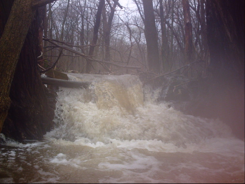
There are two impoundments where property owners have dammed the creek. Both dams (just a couple feet in height) are runnable, the first having a decent 'tongue' (and no play when I've seen it), the second being a bit more of a uniform pour-over (which could create a problematic reversal at some flows, and can provide some play at moderate flows). Coming into the first pond (first dam), there is first a driveway with low culverts. This may be possible to paddle through at low water, not likely at high water. Very shortly downstream, a low footbridge lies across the creek. At low flows, it may be limbo-able, but be careful of numerous bolts hanging below the I-beams. At best flows, this will not allow passage, and must be portaged. (The aforementioned culvert and footbridge will be passed in one portage.) Downstream of this first pond and dam, there are two driveways with totally impassable low culverts, mandating portages at all but the lowest of flows and getting out before them may be a bit tricky!
A bit futher down this area (immediately beyond a home quite near the stream) another footbridge spans the creek. This one hangs a bit low. Passage is a tight squeeze limbo even at relatively lower flows, so mandatory portage when the creek is high. Current is quite swift heading into this bridge, so you'll be in trouble quickly if you have not looked ahead and assessed your options.
Just before Hawthorne Road you'll encounter the second pond and dam. The dam lies immediately beyond the downstream side of a driveway bridge. At high water, you'll have to duck to make it under the bridge, then immediately be ready to hit the drop. The dam slopes/slides into a short pool, and (at some flows) may allow some play, though it may get a bit retentive at some flows. Just downstream the bends to the right (south), and gradient picks up a bit leading down to the Hawthorne Road culverts. This area has been prone to snags and sweepers (overhead hanging branches), which complicate the approach to the culverts. Current is pretty swift heading toward them (and through them!), so be very careful here! You need to make sure there are no snags on/in the culverts, and line up very carefully to drop through the culverts! Generally the best approach is to charge into a river-right (creek-right?) eddy to kill your momentum, then peel-out to line-up and drop into the culvert.
The second half of the run (from Hawthorne Road) starts with some boulderbed rips through heavily wooded area (which has a couple of large lots and expensive homes). Rounding the first sweeping left-hand bend (if you are VERY observant) you may see a small bit of dells (short rocky outcrop on either shore) and what appears may be remnants of a long-defunct dam. A large tree (to river-right) and some smaller ones accumulate a pile of strainers. Passage is usually possible off to the left.
Just downstream lies a wide-open cow-pasture area (at 'Creekside Valley Farm'). You'll encounter a multi-strand smooth-wire fence across the creek. Generally I've found best choice is to the right (likely carefully pushing over/through random wood/debris, dropping over the root ball, then either in your boat ducking under the fence, or portaging). Be aware (whether trying to boat under or portage) that the fence may be electrified! If it's in the water, or if a branch lays against it, it may be 'shorted out'. I do not mean to 'recommend' it, but if you are inclined to test it, extend your paddle underneath it, then lift the paddle to touch the wire. (NOTE: Regardless the composition of your paddle, (fiberglass, carbon, wood, or plastic) it is likely to be more than wet enough to conduct the electricity to your hand. You'll likely get a quite significant tingle/shock, but generally not so much as to cause any real harm.)
Swiftwater and low banks through the pasture lead to the bridge at Wauwatosa Road (CTH.N/Hwy.181). Spanning the entrance to this box-culvert, there is another smooth-wire triple-strand fence, again likely electrified. I've been able to lift a wire enough (when it was not electrified) to lay back and squeeze under, but when I heard it crackling with electricity (or performed the paddle-touch test and got the jolt/tingle), I opted to carefully get out, thread myself and my boat under or through the fence without touching it, and portage the highway. Occasionally, after high-water, the bottom strand may be snapped (by wood catching and straining it), allowing limbo passage under the higher strands.
Another pasture lies beyond the road. At the end of this pasture, look for the third (final, possibly electrified) fence as the creek enters a woodland with massive deadfall. (Note: in spring of 2013, this fence seemed absent. It is possible this lower pasture is no longer being used, or it may just be the fence is in temporary disrepair.) In the woods below, the massive deadfalls (in conjunction with the low banks) have caused the creek to split into a multitude of braided obstructed channels. The far-left channel seems to have been cleared in recent years. Well, 'cleared' is a relative term -- expect some very slalom-like moves to negotiate the meanders between trees, and be aware that this ends in a few major snags which will have to be portaged. Good luck!
Immediately after the channels rejoin (and the 'real' Pigeon Creek has joined from river-right), there's a clearing in the woods (and a paved driveway off to river-left). You'll find a few easy, fun bedrock slides which may actually offer some repeat play (at good flows). A short ways downstream, the creek passes a driveway bridge (plenty of clearance to paddle through), and enters another heavily wooded area (again with low riverbanks). Unfortunately, there's some new deadfall (huge tree-trunks) blocking the whole creek. As you portage those (recommended on river-left), you'll reach a clearing for high tension power lines. Immediately downstream, the creek encounters the final sweet sloping bedrock rapids. While it is not all that long or difficult, scouting is virtually mandatory due to the likelihood of snags or strainers midway down this drop. The creek zigs and zags, so you can't see top-to-bottom, and there are no eddies, so you need to know that it is clear before you proceed!
After the zig-zag, as the creek bends to the right, a short (~1') ledge/wave is encountered. For years, the next section of creekbed was piled (deep and long) with snags accumulated over years and years, and the creek braided out to flood a significant amount of floodplain area. In the spring of 2011, WIDNR or some fishing-group has done some major chainsawing/clearing, and you could stay in the creek channel. (I expect wood may now be re-accumulating.)
As soon as you exit the woods you encounter the railroad tracks, another power-line right-of-way, and a bike path. At best boatable flows, the railroad bridge will not allow passage under. There MAY be enough water in side ditches of the railroad to paddle south (out of the main flow), but current may be swift trying to take you under the RR bridge -- be prepared to scramble! It is likely you will have to carry out toward Highland Road, using the paved bike path.
On the rare occasion that this run is paddled, it is likely to be paired with Cedar Creek (only about 3.5 miles away), or with the run at Menomonee Falls (about 10 miles away) or other area runs.
Rapids in this Run (2)
Playspots (2)
Hazards & Portages (11)
Caution: The following locations may require scouting or portaging. Always check current conditions.
 Hazard
Culvert and Footbridge
 Hazard
First Private Dam
 Hazard
Small Impassible Culverts #1
 Hazard
Small Impassible Culverts #2
 Hazard
Footbridge
 Hazard
Second Private Dam
 Hazard
Electric Fence #1
 Hazard
Electric Fence #2
 Hazard
Electric Fence #3 / Braided Channels
 Hazard
Bedrock Slide
 Hazard
Slip-and-slide
Difficulty
Class II
Length
2.6 mi
Gradient
50 ft/mi
max 70
Rapids
2
11 Hazards
Access Points
Shuttle Info
Doing the 'full run' (as listed here) starts off with almost a mile of relatively lower gradient tiny creek running which will contain much deadfall to hazard your way over, under, around, or through.
It may be possible to shorten the run if permission can be obtained to park in one of a couple of private driveways north of Hawthorne Road, just west of the creek crossing. Two homeowners have dams which back up ponds on their property. The first (a farmstead) also has two driveways with small culverts which are impassible by any person/kayak. The only thing of any 'significance' you'd miss by putting in downstream of these culverts would be running a small dam on that farmstead property. I have never attempted to talk with either property owner to see how 'friendly' they may be about this possibility.
Rather, I have felt it far less intrusive to use the listed put-in location, since one can park off the road on a small lane alongside the creek on the north side of the road (under the crackle of the high-tension lines). I have always knocked on the door of the adjacent home just East of the creek (the property holder of the lane) and have always found them quite agreeable to allowing a vehicle to be parked for the short time it takes to run this little creek.
Similarly, at the take-out, parking is limited. Do not park in or near gravel drive (posted no trespassing) near the tracks and bike path. However, I have been told folks have parked on either side of Highland Road at the bridge (to walk dogs or access the bike path) and not had their cars ticketed or towed.
The other possibility might be to have a 'shuttle bunny/buddy' -- someone who is not paddling, but will drop you at your put-in (either leaving your vehicle at the take-out or biding their time, reading a magazine or something to pick you up at the take-out).
Difficulty Classes
I Easy
II Novice
III Intermediate
IV Advanced
V Expert/Extreme
VI Unrunnable
Current Conditions
5-Day Forecast
Whitewater data from
American Whitewater
American Whitewater