Boyds Mill (Intersection of VA 622 & VA 649 [Browntown Rd.]) to Karo Landing (Route 340)
Linked via: Nhdplus discovery 90% confidence Synced 6mo ago
Gauge Conditions
Primary
Runnable: 2.6 – 4.3 FT
Data from American Whitewater & USGS
Run Map
Run Time Estimate
Select put-in and take-out to estimate time.
Unlock Advanced Trip Planning
See wind-adjusted speed maps, forecast planning, and detailed time estimates.
Sign in to generate an AI timing estimate for this run.
Whitewater timing varies with scouting, portages, and group pace. Use as a planning baseline.
Description
Gooney Run is located south of Front Royal, Va. and offers Washington-region paddlers a close-by Class III-IV creek run with several Class IV rapids and good technical whitewater. This creek shouldn't be taken lightly, as it's full of every conceivable river hazard and can be packed with wood. The creek runs through a beautiful and intimate gorge that is lined by privately owned land, so boaters should be on good behavior to keep the creek accessible. Gooney comes up only in the winter and spring and during prolonged wet periods.
Access:
THE DEAL ON PARKING. Parking access is limited on both ends of the run. At the takeout, you can pay $2 to park at _Gooney Run Campground_ when it is open. If parking in the pullout at the Hwy 340 bridge, you will also have to cross campground land to reach your vehicle (they own both the land on both sides of the bridge), so please pay the proprietor when parking there as well. The $2 fee is the campground's day visitor rate. Parking is also available at the Karo Landing fishing access, but there are only a few spots and you must not park on the grass. At the Browntown Rd. putin, pull off the road at least 10 feet beyond the guardrail river left of the creek. Please don't block the gravel easement adjacent to the guardrail that provides access to a private wooded area (There is a _No Parking_ sign on the guardrail here).
Rapids:
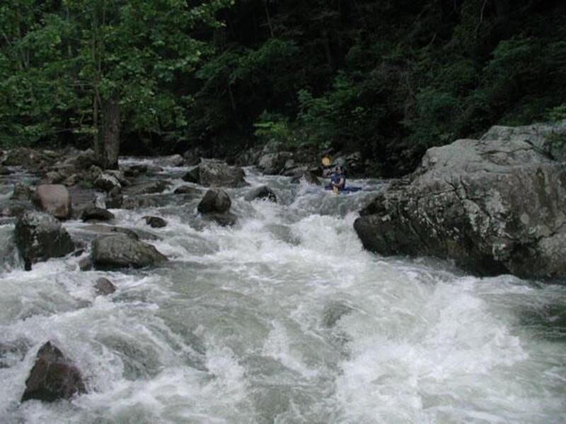
The run begins with a straight stretch paralleling the road and behind several houses. Be mindful of the ford crossings as you warm up above the gorge. Shortly after the creek cuts away from the road you will enter the gorge and the rapids pickup to II-III. After the first solid III, be on the lookout for First Falls, a Class IV+ with dangerous boulder sieves in the middle and lower right. The middle sieve is often full of wood, meaning this drop is often a mandatory portage that is easiest on the right. Immediately below is Second Falls, another Class IV. Scout after making your way into a tight eddy behind a boulder on the right.
Below Second Falls the creek alternates between Class III boogie and bigger drops. No Place To Swim (Class IV) is a longer rapid with a mean pourover that must be boofed midway through. Chainsaw (Class III+) should be eased into or scouted on the left because it's often full of new wood. Did I mention wood? This creek picks up strainers quickly and demands quick reflexes from those who boat it. Another rapid to watch out for is Surprise (Class IV), which marks the end of the big drops. Enter this rapid on the left and look for a midway eddy that helps you line up for the final flushing drop. Below here the creek eases up to the takeout beyond the Rt. 340 bridge.
Directions:
DIRECTIONS: - From Front Royal, Va., take Hwy 340 south to the bridge over Gooney Run. This is the takeout. Parking is available at the Karo Landing fishing access - accessed by turning right just before the bridge, at the bridge or at the campground. To reach the takeout, head back north on Hwy 340 a short distance and turn right on Poor House Road. Turn right again on Browntown Road. And, finally, turn right onto Buck Mountain Rd, cross over Gooney.
From Steve Marchi's Website:
_Photo: Steve Marchi runs First Falls, courtesy of Steve._
Gradient, in ft/mi., mile-by-mile: 45 (1.1 mi.), 70, 120, 80.
Check Steve Marchi's Gooney site for up-to-date info on Gooney.
Quotes from Steve's site, used with permission:
If Gooney comes up and you decide to run it, bring a bow saw for any strainers that you may encounter.
The rain gauges for Gooney's watershed are located on Hogback Mountain and at Browntown. Follow the link: Rain Gauges for Hog Back Mountain and Browntown.
_Next photo: Bob Walsh clearing a strainer at 'Chain Saw Rapid,' also courtesy of Steve._ Click on the picture for a bunch more excellent pics in Steve's site.
Ed Evangelidi testifies:
When lower Gooney Run is up, the upper stretch through the Browntown valley area is usually canoeable too. This seldom paddled stretch of fast water through mild rapids has only a few problems. One section braids a lot and it may be difficult to find deep water and one bridge has a strong series of barbed wire strands not only across the creek, but also up the sides of the portage route. But this section is a suggestion to lengthen an otherwise short Gooney Run trip.
See Also:
_Classic Virginia Rivers,_ Ed Grove (1992 ed), p. 149.
_Virginia Whitewater_, Roger Corbett (2000 ed.), p. 87.
_Exploring Virginia's Waterways_, Ed Gertler (2022 ed.), p. 31.
Waterfalls (3)


Hazards & Portages (3)
Caution: The following locations may require scouting or portaging. Always check current conditions.


Difficulty
Class III-IV+
Length
3.9 mi
Gradient
78 ft/mi
max 120
Rapids
0
3 Hazards
Access Points
Difficulty Classes
I Easy
II Novice
III Intermediate
IV Advanced
V Expert/Extreme
VI Unrunnable
Current Conditions
5-Day Forecast
Whitewater data from
American Whitewater
American Whitewater