Chagrin Reservation
Linked via: Nhdplus created 95% confidence Synced 6mo ago
Gauge Conditions
Runnable: ? – ? CFS
Approximate reading: This gauge is 4.4 miles away on Chagrin. Use as a general reference only.
Data from American Whitewater & USGS
Run Map
Run Time Estimate
Select put-in and take-out to estimate time.
Unlock Advanced Trip Planning
See wind-adjusted speed maps, forecast planning, and detailed time estimates.
Sign in to generate an AI timing estimate for this run.
Whitewater timing varies with scouting, portages, and group pace. Use as a planning baseline.
Description
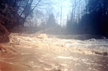
This one is mainly a surfin' fiesta, but it starts with a gnarlistic bang: an 8-foot waterfall, followed immediately by a huge hole which can be mean to the unwary, shown in the photo at the top. (Don't ask how I know.)
After the first waterfall there is a nice slide with a hole at the bottom--nice for surfing on river right. After that there are some waves and then a 5-6 foot waterfall. Then some flat water to a little ledge and some nice surfing waves, then you go under the Miles Rd. bridge. You want to go river-right around an island--watch out for the strainer. A little afterwards will be the takeout, on river left where Sulfur Springs enters the Chagrin.
Putin: Bill Weeber, of the Keel-haulers Canoe Club, says: "The putin is off Solon Rd. at the Table Rock Picnic Area between Cannon Rd. and Chagrin River Rd. To run shuttle, take Solon Rd right to Cannon Rd. right. Go down Cannon about 1/4 mile and hang a right on Arbor Lane in the metro park. Take that to Chagrin Parkway, hang right and then a quick left onto Sulphur Springs Drive to Miles. Cross Miles and go straight on Chagrin River Rd. for about 1/8 mile; parking is on the right. You should be able to see the Chagrin River from there and Sulphur Springs Creek where they converge."
Takeout: Joe Ryan says: "There are two takeouts as I recall. There's one off Chagrin River Road at the bridge that's right after the best of the whitewater (easily a bike shuttle). The second is at the intersection of Miles and Chagrin River (entrance of SC Reserv.). It includes a small 2' ledge/wave train but also a steep, slippery hike up the gorge. But hey, there's also a nifty 10' fall on a side creek on the way out."
Joe also points out that the Chagrin River Road bridge has been out for 15 years. That explains why you have to go the long way around from the Solon Rd. putin to the farther takeout.
Here's another drop. Too bad all the tree stuff was in the way. If you look closely, there's a hint of a boater in there.

Waterfalls (1)
Hazards & Portages (1)
Caution: The following locations may require scouting or portaging. Always check current conditions.
Difficulty
Class III-IV
Length
1.4 mi
Gradient
40 ft/mi
max 45
Rapids
0
1 Hazard
Access Points
Difficulty Classes
I Easy
II Novice
III Intermediate
IV Advanced
V Expert/Extreme
VI Unrunnable
Current Conditions
5-Day Forecast
Whitewater data from
American Whitewater
American Whitewater