Confluence with Buck Creek to Confluence with Upper Creek
Linked via: Proximity 95% confidence Synced 6mo ago
Gauge Conditions
Runnable: ? – ? CFS
Approximate reading: This gauge is 7.1 miles away on Steels Creek. Use as a general reference only.
Data from American Whitewater & USGS
Run Map
Run Time Estimate
Select put-in and take-out to estimate time.
Unlock Advanced Trip Planning
See wind-adjusted speed maps, forecast planning, and detailed time estimates.
Sign in to generate an AI timing estimate for this run.
Whitewater timing varies with scouting, portages, and group pace. Use as a planning baseline.
Description
*This section does not include the upper section with Screaming Right Hand Turn Falls & Teacups Falls.*
If you have an hour or two, take the time to hike the Mountains To Sea trail between FR228 and FR496 to see the incredibly beautiful and dangerous upper section of Steels Creek. Dropping at about 450 feet per mile, the CA-like 'teacups' section drops over 200 feet in one tenth of a mile of waterfalls, slides, teacup-shaped pools, caves, strainers and sieves.
Now get the upper section outta your head and lap the ~110 feet per mile 1.1 mile middle roadside section from the end of FR228 to the island takeout. You can also lap the entire 2.2 mile middle section by running down another 1.1 miles to the confluence with Little Fork and hike the trail back up to FR228.
If you want more action you can hike up the trail from the end of FR228 and bite-off runnable Upper Rocky Broadish type pieces in the 120 to 200 feet per mile range.
Below Little Fork the creek drops around 10 to 20 feet per mile as a scenic class II with one or two man made obstacles to portage.
If you run Steels be sure to send a visual from the Upper Creek bridge gauge to the StreamTeam.
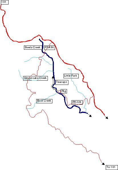
Directions to Put-In
On Highway 181 (North out of Morganton or South from Linville/Blue Ridge Parkway) 0.2 miles south of the 17 mile marker you will turn west onto FR228. Along FR228, at 1.7 miles you will cross Little Fork, at 2.8 miles you will see the Island take-out for the Middle Roadside Section, the Buck Creek Confluence is at 3.6 miles. At 3.9 miles the road ends at a parking lot with a trail running north along the east side of the creek. Cross the creek and you will hit the Mountains-to-Sea trail that will take you up to the Teacups and eventually up to FR496 (which also intersects with highway 181 near the 21 mile marker).
Rapids in this Run (1)
Difficulty
Class II-III+(IV)
Length
7.5 mi
Gradient
55 ft/mi
max 110
Rapids
1
Access Points
Difficulty Classes
I Easy
II Novice
III Intermediate
IV Advanced
V Expert/Extreme
VI Unrunnable
Current Conditions
5-Day Forecast
Whitewater data from
American Whitewater
American Whitewater