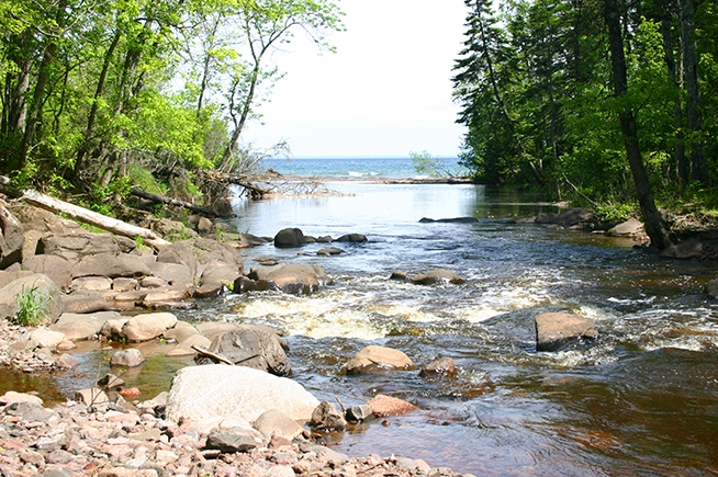
Cty 33 to Lake Superior (6.5 miles)
Linked via: Nhdplus gnis 95% confidence Synced 6mo ago
Gauge Conditions
Runnable: 300.0 – 1,000.0 CFS
Likely too low. Correlation to reference gauge uncertain. Visual inspection required.
Data from American Whitewater & USGS
Run Map
Run Time Estimate
Select put-in and take-out to estimate time.
Unlock Advanced Trip Planning
See wind-adjusted speed maps, forecast planning, and detailed time estimates.
Sign in to generate an AI timing estimate for this run.
Whitewater timing varies with scouting, portages, and group pace. Use as a planning baseline.
Description
The Big Sucker is perhaps one of the easiest North Shore creeks to catch with water. From Cty 33, there is about a half mile of light rapids with one low ledge sequence. You'll want to get out and scout the next steep, twisting drop that changes directions abruptly several times in a narrowed channel that feeds almost immediately into a 12', high angle slide.
This is followed primarily by light rapids and flatwater with a decent current speed. Passing under Ryan and Berquist Rds, there are no more significant drops until the woods open up for a powerline frontage. There is a low ledge shortly after and then the main action begins.
There are two slide sequences that can be a bit scrapy at lower flows. The second is terraced at the top and has a "ski jump" in the center at the bottom. At this point the river makes a hard turn to the left. Get out on the right to scout the next sequence here as eddies become somewhat scarce below.
The river looks innocuous here but just around the next bend is "The Bunny" (named with references to Monty Python and Energizer battery commercials). The river drops 100' in the next 0.2 miles. Around the corner lie a pair of ledges, then most of the current funnels down into a narrow, violent slot dropping about ten feet -- this route hurts, trust me. Instead, after the ledges (which will likely leave you river-left) cut hard to far right across the lip of the main (slot) drop, to hit a small bypass channel. Watch for a potential "head and tail" pin here and angle left at the bottom to avoid the rock wall. This is the most difficult part of the drop but the fun is just beginning.
Ten yards below, there is a short ledge leading into a small vertical that drops into a pothole; watch the overhanging rock on the left. This feeds immediately into another small vertical where it is necessary to come off with hard left angle to avoid pitonning the facing rock. At higher flows it is possible to run a slide to the left here. Just downstream are a pair of ledges, 4-5', for a double boof followed by running water into a slot with a twist at the bottom that feeds onto a low angle slide for the finish. Much, much fun. Taken piece by piece, the drop may only be class IV. However, the length and complexity of this drop (especially at moderate to high water) generally merit a class V rating.
There is a small slide just below and then some light water for a brief stretch before "Goosed", a fairly straightforward drop with a pourover near the bottom that tends to tailstand boats. Just downstream is "Two Step", a pair of small verticals into potholes with a hole after the second (that has an appetite for small boats) followed by a small sloping ledge. There's another short stretch of running water before the finale to the steepest section.
"Five Step" is a staircasing series of five drops into potholes dropping 16-18' total. The holes can be very aggresive though if you can hit several boofs in quick sequence, the drop's a cinch. There are light rapids down to the bridge at Old North Shore Rd but watch for a section which was badly wooded up after the big 4th of July Storm of '99.
Light rapids bring you down to the long culvert under Hwy 61 and shortly after, there are some ledges that lead into a slightly bigger sequence. More class II stuff and you may begin to encounter fishermen coming into the drop under the railway bridge leading into "Sucker Punch". This drop isn't difficult be warned: the 'wave' just below the ledge is not just water. Run with right angle and float down to the mouth.
Hang a right (south/west) and paddle Lake Superior for maybe ten minutes to take out on the public beach.
At lower flows, the upper and lower sections get scrapy so it may be advisable to shorten the run by carrying in on the power line frontage off Berquist Rd (maybe a quarter mile) and take out at Old North Shore Rd.
There are a number of references to "potholes" in the description. This is not entirely accurate. The river was modified by the DNR to improve upstream fish passage. The modification was done with explosives, so those potholes should more accurately be referred to as blast craters. Therefore, be aware there will be sharp edged rock (not yet smoothed and dulled by time) at and downstream of these drops.
Rapids in this Run (19)
 Rapid
Rapid
Ledge
 Rapid
Rapid
Ledge
 Rapid
Rapid
Rocks/Ledge
 Rapid
Rapid
Ryan Road/FR10
 Rapid
Rapid
Berquist Road/258
 Rapid
Rapid
Powerline Crossing
 Rapid
Rapid
Rapids Sequence
 Rapid
Rapid
Rapids
 Rapid
Rapid
Quick Drop
 Rapid
Rapid
Five Step
 Rapid
Rapid
Old North Shore Road/290
 Rapid
Rapid
Short Slide?
 Rapid
Rapid
Hwy.61
 Rapid
Rapid
Ledges
 Rapid
Rapid
Ledge/slide
 Rapid
Rapid
RR & Old Hwy.61
 Rapid
Rapid
USGS sampling site
 Rapid
Rapid
Mouth of the Sucker
 Rapid
Rapid
Public Beach / Landing
Difficulty
Class III-IV+(V)
Length
5.8 mi
Gradient
104 ft/mi
max 228
Rapids
19
Access Points
Difficulty Classes
I Easy
II Novice
III Intermediate
IV Advanced
V Expert/Extreme
VI Unrunnable
Current Conditions
5-Day Forecast
Whitewater data from
American Whitewater
American Whitewater