D) Hwy 101 to Pine River (6.4 miles)
Linked via: Proximity 90% confidence Synced 6mo ago
Gauge Conditions
Runnable: 200.0 – 1,000.0 CFS
Too low for reasonable whitewater. (May be paddled as a scenic float trip, but all gradient will be a scrape or carry.)
Data from American Whitewater & USGS
Run Map
Run Time Estimate
Select put-in and take-out to estimate time.
Unlock Advanced Trip Planning
See wind-adjusted speed maps, forecast planning, and detailed time estimates.
Sign in to generate an AI timing estimate for this run.
Whitewater timing varies with scouting, portages, and group pace. Use as a planning baseline.
Description
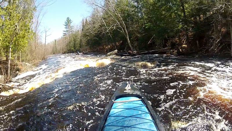
This remote, scenic run is 89% swifts/flatwater. 3 rocky rapids (I-II) have drops over bedrock shelves (II-III). Trip time 2.5-5 hrs (avg 3.5)
Little input (30cfs) to flow from groundwater (springs) is a limiting factor for this river. The best water levels are usually not from snowmelt. They are from early spring rains that come when the ground is still frozen until trees fully leaf-out. A rain of 1” at this time will provide excellent water levels while during the summer it may take a 3” rain (See Photos Tab: Popple River Flow Pattern Graph)
In 1965 the Popple River became a State of Wisconsin, designated “Wild River.” This state designation pre-dated and was the model for the national Wild and Scenic River program. Because of this special designation, today over 95 % of the land along this stretch of the Popple is owned and protected from development by the WI DNR and Florence County. Geologically the bedrock outcrops (at each falls) along this stretch is metamorphosed basalt and intruded volcanic granite that originally solidified off the ocean floor south of the equator nearly 2 billion years ago. It is some of the oldest rock in North America. The unique values of ancient bedrock and wildness add depth and value to your run down this remote stretch of river.
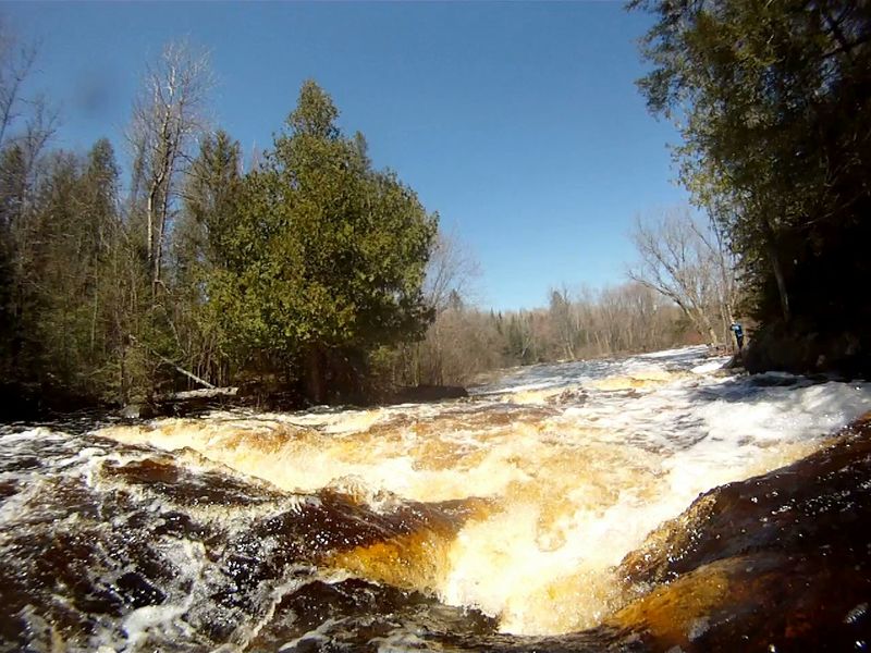
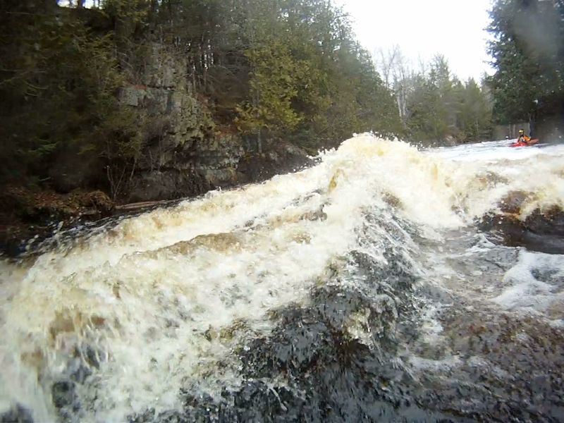
Drops include _Champeau(II), Washburn Falls(III),_ and _Jennings Falls(II+ to III)._ Only _Washburn Falls_ has a marked portage trails that facilitates scouting. _Champeau ca_ n be viewed from East River Rd off (from Hwy 101). _Jennings_ is usually scouted from the right shore. Lining or portaging (no trail) on the right is a possible option. None of these are "falls" in the traditional, vertical sense.
_Champeau_ is a short, small ledge drop with a fun s-shape path. The drop is a quarter of the way into a long (1/3 mile) complex rocky rapids ( _I-II_)
_Washburn Falls,_ being a close, cascading sequence of 5 ledge drops with big action, is the most difficult and exciting rapids on the Popple.
_Jennings Falls_ is in a rock-walled gorge that, more or less, lasts all the way to the Pine. It is a fast, one-drop plunge into a significant standing wave that has aeriated water one side and a vertical rock wall on the other – very quick, very exciting.
Arranging to use the river-left takeout (45.839427, -88.338503) is a make-or-break necessity for this trip. All other shuttle options are discouraging or dangerous. The ¼-mile gravel drive from the end of Jack Pine Drive to the takeout landing is on private property and is gated but available to paddlers who obtain permission. For permission to use the river-left takeout (or arrange shuttle assistance) contact Dwayne of Wild Rivers Adventure Co. (Florence, WI) at 715-528-5266 or 715-952-8027. From the river, the unmarked landing is 250 feet downriver from the confluence with the Pine River, immediately past the iron-post remnants from the long-gone bridge. Start down the river-wide Class-1 but eddy-out left, immediately, before this minor swift takes you any distance downriver. The shuttle distance from this takeout is 7.7 miles mostly on paved road (Hwy 101). If you choose to bike back (1 hour trip) take note that there are 3 steep downhill runs and 2 steep uphill climbs, each of 150 vertical feet. Other shuttle alternatives are a) 1.5 up-river on the Pine to Hwy 101, b) river-right public landing that is often impassable or a slow, rocky, 16-mile shuttle, or c) continue 4-7 more miles downriver (with portage(s)) around major waterfalls.
Rapids in this Run (2)
Playspots (1)
Hazards & Portages (2)
Caution: The following locations may require scouting or portaging. Always check current conditions.
Difficulty
Class II(III)
Length
6.1 mi
Gradient
11 ft/mi
max 13
Rapids
2
2 Portages
Access Points
Shuttle Info
Arranging to use the river-left takeout (45.839427, -88.338503) is a make-or-break necessity for this trip. All other shuttle options are discouraging or dangerous. The ¼-mile gravel drive from the end of Jack Pine Drive to the takeout landing is on private property and is gated but available to paddlers who obtain permission. For permission to use the river-left takeout (or arrange shuttle assistance) contact Dwayne of Wild Rivers Adventure Co. (Florence, WI) at 715-528-5266 or 715-952-8027. From the river, the unmarked landing is 250 feet downriver from the confluence with the Pine River, immediately past the iron-post remnants from the long-gone bridge. Start down the river-wide Class-1 but eddy-out left, immediately, before this minor swift takes you any distance downriver. The shuttle distance from this takeout is 7.7 miles mostly on paved road (Hwy 101). If you choose to bike back (1-hour trip) take note that there are 3 steep downhill runs and 2 steep uphill climbs, each of 150 vertical feet.
Other shuttle alternatives are a) 1.5 up-river (no rapids but there is current) on the Pine to Hwy 101, b) river-right public landing that is often impassable or a slow, rocky, 16-mile shuttle, or c) continue 4-7 more miles downriver (with portage(s) around major waterfalls
Difficulty Classes
I Easy
II Novice
III Intermediate
IV Advanced
V Expert/Extreme
VI Unrunnable
Current Conditions
5-Day Forecast
Whitewater data from
American Whitewater
American Whitewater