Deer to Murray (7.3 miles)
Linked via: Proximity 97% confidence Synced 6mo ago
Gauge Conditions
Runnable: ? – ? CFS
Approximate reading: This gauge is 10.5 miles away on Little Buffalo. Use as a general reference only.
Data from American Whitewater & USGS
Run Map
Description
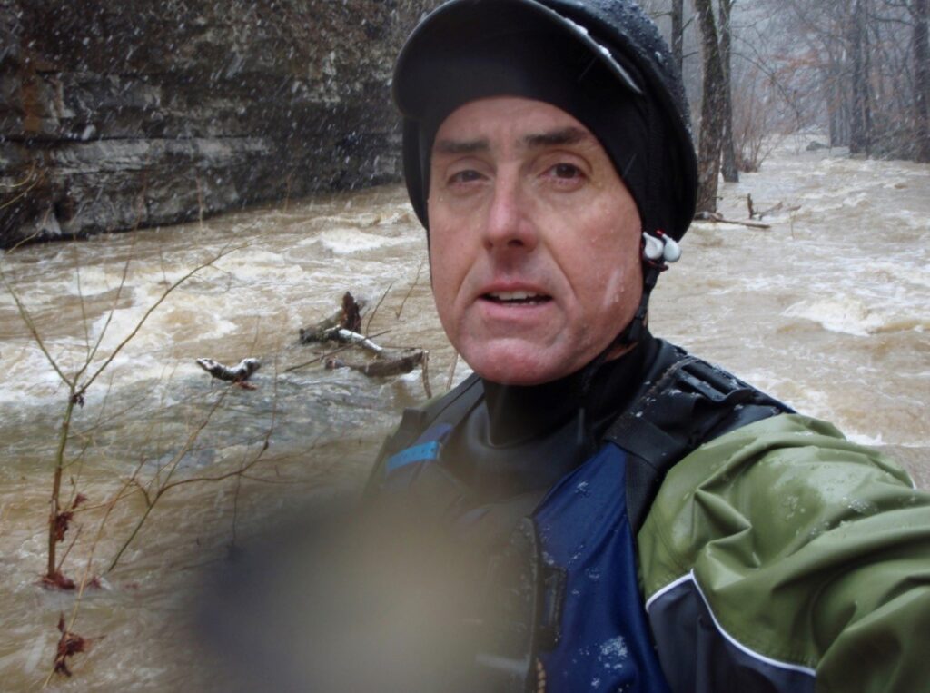
Note: The combination of Steep banks and lots of dead red oak trees (thanks to the borer beetle infestation) tend to clog the creek with wood from time to time, so keep look out. Currently has trees at the end of the 2nd (Obliterator) and 3rd (Swinging Bridge) gorges!
Put-in: Located at confluence of the East Fork and Barberry Creek.(elevation 1490) From Hwy 16 at Deer. Go North on County Road 8872 for 2.7 miles to the end of the main road. Ask for permission to park at the last house overlooking a large pond and carry/drag down the old road 1 mile to the creek.
Take-out: At Murray either at low-water bridge below confluence with Stepp Creek (Elevation 1065) or on river left at low-water bridge below confluence with Thomas Creek (Elevation 1030). 3-options:
Option 1, Go West on Hwy 16 to Swain and turn North on County Road 8920, go 3.1 miles and take the right fork on County Road 8642. This road will descend the mountain to the low-water bridge at Murray. Park along the road/creek as you will likely not be able to ford the creek to the park/community building if the creek is running.
Option 2, Go North on Newton County Road 8876 from Hwy 16 at Deer and head to Wayton. This road takes you past the Alum Cove recreation area. Turn left (West) on Newton County Road 8500 at the Wayton Baptist Church. Go 2.3 miles and turn left (South) on Newton County Road 8541(Snow cemetery is on the right). Continue ~2.5 miles down the mountain to the community of Murray. Be sure to check out the scenery on the way down. Especially the tall waterfall above the first small creek crossing. At the bottom of the hill, there are a couple of houses on the right then a triangle intersection. The creek is a couple hundred yards to the left. Park at the community building next to the intersection. Be sure to thank any locals and leave a donation for this facility.
Option 3, Access from Hwy 21 just North of the Hwy 16 intersection and turn right (East) on Newton County Road 8050 (Shiloh Road). Follow for 4.5 miles and turn right on Newton County Road 8125 down to just below the confluence of Thomas Creek and The EFLB. This adds an additional 1.2 miles of slow class I/II. There may be a barb-wire fence just below the upper take-out for Options 1 or 2, so be advised if using Option 3.
If the water is high (2+ inches of rain) you might check out Sandy Springs Hollow (aka Mystery Creek) or Barberry Creek. These add ~ 2 miles to the top of the main run with some good Class III/V drops and some waterfalls. The EFLB will be big and flooded if these are running.
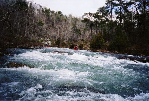
Run starts off with some brushy class II+ but quickly picks up volume as several small drainages pour in. Some nice waves and holes to play on. About 2 to 2.5 miles in, look for the banks to steepen and the river appears blocked by some large boulders. There is a small cascade on river left as it falls over and through the steep limestone bank just above a nice eddy on river left for the scout/portage on river left. This is Johnson's Falls, the water funnels into a 2.5-ft wide notch between the wall on the left and an undercut boulder on the right while making a 90-degree turn and droping several feet. This drop has been run with varying degrees of success.
Below here, the class III/IV boulder gardens start and continue until the take-out in option 1 and 2 above. Watch out for the 'Obliterator Hole' around mile 5. There is a ATV trail on river right from here down to the first house on the creek, in case you run into trouble with the holes. The final drops are just below this house. There is an old 'swinging bridge' above these drops for added interest.
See more info on the Ozark Whitewater Page for EFLB.
Rapids in this Run (4)


Playspots (1)

Hazards & Portages (1)
Caution: The following locations may require scouting or portaging. Always check current conditions.

Difficulty
Class III-IV(V+)
Length
7.4 mi
Gradient
60 ft/mi
max 90
Rapids
4
1 Hazard
Access Points
Shuttle Info
**Put-in:** Located at confluence of the East Fork and Barberry Creek.(elevation 1490) From Hwy 16 at Deer. Go North on County Road NE198 (Heydenrich Road) for 2.7 miles to the end of the main road. Ask for permission to park at the last house overlooking a large pond and carry/drag down the old road 0.5 miles to the creek. This road might be passable in a serious 4-WD, but is just easier to walk down.
**Take-out:** At Murray either at low-water bridge below confluence with Stepp Creek (Elevation 1065) or on river left at low-water bridge below confluence with Thomas Creek (Elevation 1030). 3-options:
Option 1, Go West on Hwy 16 to Swain and turn North on County Road NE 8, go 3.1 miles and take the right fork on County Road NE 171. This road will descend the mountain to the low-water bridge at Murray. Park along the road/creek as you will likely not be able to ford the creek to the park/community building if the creek is running.
Option 2, Go North on CR 28 from Hwy 16 at Deer and head to Wayton. This road takes you past the Alum Cove NFS recreation area. Turn left (West) on CR 96 at the Wayton Baptist Church. Go 2.3 miles and turn left (South) on CR 95. Snow cemetery is on the right. Continue ~2.5 miles down the mountain to the community of Murray. Be sure to check out the scenery on the way down. Especially the small but tall waterfall above the first creek crossing. At the bottom of the hill, there are a couple of houses on the right then a triangle intersection. To the left, Willis Park is beside the creek at the low-water bridge and the will probably have standing water in the field. Park at the community building next to the park at the intersection. Be sure to thank any locals and leave a donation for this facility.
Option 3, Access from Hwy 21 just North of the Hwy 16 intersection and follow the road down to just below the confluence of Thomas Creek and The EFLB. This adds an additional 1.2 miles of slow class I/II.
AWA auto route below is based on Option 3, which if the creek is flowing good, you will have to park at the river crossing downstream of Thomas Creek.
Difficulty Classes
I Easy
II Novice
III Intermediate
IV Advanced
V Expert/Extreme
VI Unrunnable
Current Conditions
5-Day Forecast
Whitewater data from
American Whitewater
American Whitewater