E) Lower: Conglomerate Falls to Lake Superior (2.0-2.6 miles) Scenic
Linked via: Proximity 94% confidence Synced 6mo ago
Gauge Conditions
Runnable: 200.0 – 500.0 CFS
Data from American Whitewater & USGS
Run Map
Put-in
Take-out
Rapids/Hazards
Scenic
Run Time Estimate
Select put-in and take-out to estimate time.
Unlock Advanced Trip Planning
See wind-adjusted speed maps, forecast planning, and detailed time estimates.
Sign in to generate an AI timing estimate for this run.
Whitewater timing varies with scouting, portages, and group pace. Use as a planning baseline.
Description
Quick Facts:
Location: Western Upper Peninsula, about 10 miles North of Bessemer.
Shuttle Length: 2.2 miles. (See details in "Directions" Tab.)
Character: AMAZING geology creates some classic drops.
Drainage: 200 sq.mi. (at gauge site upstream).
Google Maps has excellent resolution aerials of this reach. We highly recommend clicking the "Access" tab, clicking the Put-In Coordinates, then clicking 'Satellite' icon (bottom left), and then scrolling downriver to do a 'virtual flyover' down the reach. (Note: Once you have the "satellite" view, you can "click-and-drag" to scroll your way downriver. \*\*OR\*\* after you have once clicked-and-dragged ... you can use the "arrow keys" on a computer keyboard to scroll the map in any direction.)
* * *
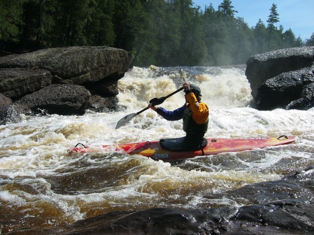
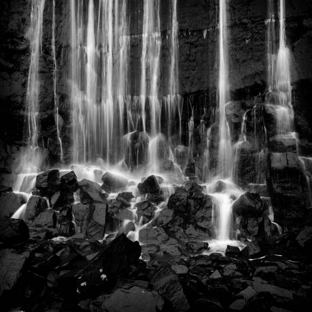
Amazing geology creates some of the most interesting and unique drops in the Midwest. Due to the constricted nature of many of the drops, the range of runnable levels is somewhat narrow. Scouting is highly recommended at virtually all of the drops, as once you start into a drop, there is often no way out. A snag in the lower part of any drop could be exceedingly problematic. Some of the drops do not lend themselves to setting any 'meaningful' safety, nor to allow convenient rescue setups. Best to be cautious.
While we list the reach as starting at Conglomerate Falls (mostly for continuity from prior segments), many boaters will choose to put in about a mile downstream, below Gorge Falls. Even with the shortened run at just about two miles, allow plenty of time for this awesome run. You will be scouting most drops, and you'll probably want time for photos and video.
(The 'short' run stats are: length=1.95mi, ave.gradient=95fpm, max.full-mile-gradient=108fpm.)
While extreme boaters have run every drop on this reach, less experienced (or let's be kind and just say less 'adventurous') boaters may find themselves portaging the big stuff. (My standard line was "you carry your boat almost as much as it carries you.") Even with _up to_ three portages, there is more-than-enough remaining whitewater to enjoy, and the scenery is outstanding.
* * *
Drops in the upper part of this reach (which many will choose to bypass) include:
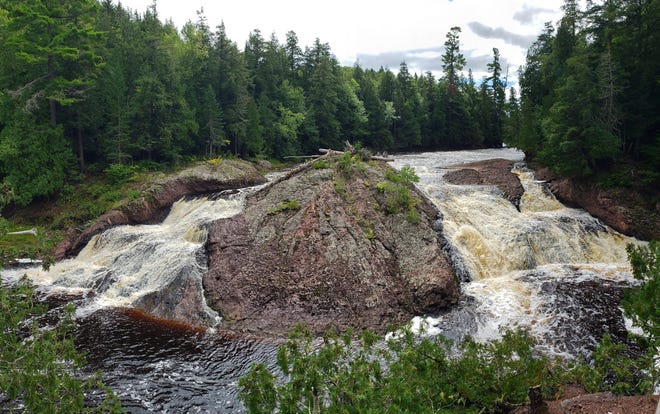
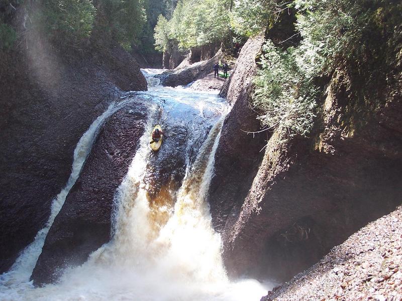
0.0 miles Conglomerate Falls (25-30'): A large dome of rock divides the flow into three channels. The main (center) channel has a sweet, simple slide into a generally not keepy hole. There are, however, some known piton possibilities, particularly on the right side of the slide/hole.
0.5 miles Potawatomi Falls (40'): Again, a large dome of conglomerate rock spreads the flow across a wide span of river. With runnable levels for the rest of the river, flow across this rock is exceedingly sparse. Attempts at running this drop are often amusing and scary, as boaters have trouble maintaining their lines as they slide down the rock sideways and backwards.
0.7 miles Birth Canal (4'): Just around the bend from Potawatomi, the river is squeezed into a narrow slot and over a short, but decidedly ugly pourover. Water boils up throughout the length of the pool (about 40'?) before Gorge Falls. It is hard to imagine a boater escaping the boiling backflow in this drop at most water levels. While I have heard of a run of this (though I have no idea at what flow), most boaters at most levels would do well to be certain to stay well clear of this drop.
0.7 miles Gorge Falls (20-30'): Flowing out of the other end of the boiling pool, the river is squeezed to about 10-15' in width as it pours over a sloping lip and into the depths of a grotto in the canyon below. Many will choose to just view it from overlooks above and again from below as they carry down steep stairs and slide boats over a locked wooden gate to drop to the rocky shore and the eddy in the canyon below.
* * *
From the more common put in one will encounter the following drops (I _think_ I have them in the correct order . . . but a couple could be 'juggled' . . . I haven't run this reach enough to recall for certain):
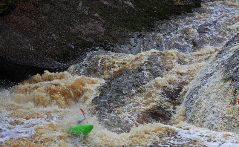
RollerCoaster: The river takes a sharp right, pours across a short irregular ledge, about a hundred yards down a 'hallway' through a couple offset diagonal waves, before dropping through another hole which will give most boaters a good shot-in-the-chest/face and completely stall their momentum. While it may flip you, at levels up to 350cfs it has not seemed overly retentive. A large pool and eddy lies below.
1.6 miles Sandstone (25' of drop spread between a main falls and a series of ledges below): A dike of rock with a slot in the center, looking almost like a breached dam. There is a potential line down the center, but there is some upturned jagged rock to either side (at the least, boat abuse, at worse, piton potential). This line feeds you into a meaty looking hole which wants to shove you out left, toward the undercut left wall. Another line is to 'sneak' off to the right into a hanging eddy/pool, then slide around the 'breach wall' to ride down a narrow tongue, avoiding the worst of the hole. Many will portage (left) around the large entrance falls to put in immediately below and enjoy the series of diagonal waves and holes which follow.
Surprise: The river splits around a large island. The right channel stays 'high' as it slides past the rock/island, through a couple diagonal waves, then pours over a 3-4' ledge (surprise!). The best line is usually staying left down the 'hallway', then crossing to drop off the final ledge tight to a rock on the right. (Not to be mistaken with going tight right early, ending up right of that rock, in a narrow channel, which is not generally recommended.)
No Surprise/Over-the-Falls: The left channel around the island mentioned above has a couple good, potentially playable waves, and doesn't loose as much altitude as the right channel. As it wraps around the backside of the island, it drops over a taller falls as it rejoins the right channel. Far left appears a fairly smooth slide, while some other lines may provide a boof into the flow below. Avoid getting too far right, as the landing will be on a spline of rock. (This is the route less taken, as most folks enjoy running Surprise, and at least looking at Under-the-Falls.)
Under-the-Falls: One of the tougher drops to run, to scout, to set safety, or to portage. The right bank is high and well wooded, and rocks at river level are sloped and slippery. A couple ledges form powerful offset holes, leading to odd currents where the flow from the left channel dumps in (see above). Rocks from the left shore (the island) are overhanging (undercut). Caution is urged for those deciding to run this. A common 'bypass' route is to do a 'double portage,' beaching on the island, carrying across, getting in the boat to ferry across the left channel (above it's falls), then beaching again to carry across a hump of rock to a convenient spot to re-enter the river below the drop.
Bump & Thump: A fun stretch of offset ledges, waves, and holes leads toward and past a large conglomerate outcropping on river left. None should cause particular trouble. More often (at levels up to 350cfs) the challenge is to keep from 'grunging out' in this stretch. A 'stealth rock' does exist in the center of the final drop, so stay left or get well to the right to avoid piton or gouging your boat.
Jills Delight: The river divides around a rock/island. Taking the right channel, a high ridge of rock rises on the left (the island) leading to a slide down sloping bedrock into a (usually) fairly tame hole. The usual line is left of center for a smooth slide, though I have seen some folks take the right side for a more abrupt drop. (Not sure about depth and 'cleanliness' . . . boof highly recommended.)
Jill's Bypass: The left channel (at the above mentioned island) has a steep pourover into a short boil, followed immediately by a narrow constriction, then slams a wall and is diverted to the right. A short ledge/wave precedes the confluence with the other channel.
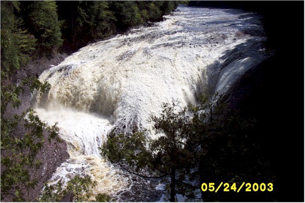
2.1 miles Rainbow(45'): One of the most beautiful and ugly, bizarre and intimidating falls in the Upper Peninsula. Take a dome of rock, then imagine taking a drill press to cut a vertical shaft out of one side of the dome. Water pours in, pounds and swirls around furiously before spewing out over a short drop into the pool below. The left side (where water sheets over shallow conglomerate) drops toward a wall, then is diverted to the right over the dome, clear of the vertical shaft, and plunges into the pool below. Again, this has been run, but most will enjoy the esthetics as they portage, usually on the left, where there is a viewing deck, and access to the river below is easier. However, to really appreciate the full beauty (and 'ugliness') of this falls, take out well above the falls on the right. Hike down a path to viewing areas above and downstream of the falls, then get back in your boat to ferry across to the left shore for the easier portage. (Access to the river on river-right below the falls is possible, but can be difficult.)
A brief, generally flatwater paddle leads to the harbor in the park at the mouth of the river.
Click here for Part 1 of an article from the AW Journal, way back in 1981!
Click here for Part 2 of the article.
The article describes the following: Michigan's, Upper Presque Isle, Lower Presque Isle, Middle Black, Lower Black, Upper Silver, Lower Silver, Falls, and Rock; and Wisconsin's Lower Brunsweiler, Montreal Canyon, and West Branch Montreal.
Rapids in this Run (2)
Waterfalls (9)
Hazards & Portages (2)
Caution: The following locations may require scouting or portaging. Always check current conditions.
Difficulty
Class IV-V(V+)
Length
7.0 mi
Gradient
110 ft/mi
max 126
Rapids
2
2 Hazards
Access Points
Shuttle Info
As stated in the description area, many boaters will start put-in at (above or below) the Potowatomi/Gorge Falls area instead of at Conglomerate Falls as listed here for the full reach. The carry in to Conglomerate Falls is fairly long, while the carry at Potowatomi/Gorge is far more reasonable.
Difficulty Classes
I Easy
II Novice
III Intermediate
IV Advanced
V Expert/Extreme
VI Unrunnable
Current Conditions
5-Day Forecast
Whitewater data from
American Whitewater
American Whitewater