E) Sturgeon Gorge: Sturgeon Falls to NF2270/FSR193 (4.87 miles) Wild
Linked via: Nhdplus discovery 90% confidence Synced 6mo ago
Gauge Conditions
Runnable: 400.0 – 2,000.0 CFS
Likely too low for reasonable whitewater run. Best flows are uncertain. Help out your fellow boaters by posting a comment about preferred flows.
Data from American Whitewater & USGS
Run Map
Put-in
Take-out
Rapids/Hazards
Wild
Scenic
Recreational
Run Time Estimate
Select put-in and take-out to estimate time.
Unlock Advanced Trip Planning
See wind-adjusted speed maps, forecast planning, and detailed time estimates.
Sign in to generate an AI timing estimate for this run.
Whitewater timing varies with scouting, portages, and group pace. Use as a planning baseline.
Description
NOTE: We have no awareness of best runnable flows. All flow ranges are merely tentative. Create a 'Trip Report' stating listed flow and your impressions (low/moderate/high).
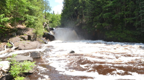
Experienced, skilled, and appropriately cautious paddlers may opt to minimize the carry-in and start at the head of the gradient (as given by the presently indicated put-in). This gives very nearly a half-mile of fine rapids leading to Sturgeon Falls. A sharp jog to the left precedes this very dangerous and deadly falls. For any and all less-skilled or timid/uncertain paddlers, we recommend instead carrying that 0.5 mile down the trail to put in below Sturgeon Falls.
Take-out is at Sturgeon Gorge Road bridge, just above Prickett Lake. Downstream of that dam, save one spot, the river is all slow, meandering low flood-plain lazy river.
This section is very scenic and mildly playful depending on water. The run starts with some Class II low angle sloping ledges and wave-holes, later turning into numerous boulder rapids with an occasional small surf wave. The majority of the whitewater features are located in the first half of this reach, which averages about 50'/mile. The second half is primarily a moving water egress paddle.
This reach, combined with the 10.9 miles of river upstream of Sturgeon Falls, is a fairly popular canoe run through a scenic valley. Starting from the USFS Sturgeon Road campground there is mostly quietwater until a short distance above the falls. For those without whitewater experience and equipment, caution is advised in the approach to the portage for the falls, especially at flows above our listed 'minimum'. There's only a small eddy before Sturgeon Falls. While there are some sweet rapids (waves and holes) in the stretch above the falls, there is extreme risk of going beyond the 'point of no return' and being swept into/over the falls. There has been at least one death as a result of misjudging this. Several years ago a paddler in a recreational kayak (non-whitewater type like the Keowee) lost control in the approach to the falls and elected to swim for shore -- he failed to make it. This was at a flow of about 700 cfs. For this reason, a put-in below the falls is recommended.
Rapids in this Run (5)
Waterfalls (1)
Difficulty
Class II-III(V+)
Length
4.7 mi
Gradient
31 ft/mi
max 76
Rapids
5
Access Points
Difficulty Classes
I Easy
II Novice
III Intermediate
IV Advanced
V Expert/Extreme
VI Unrunnable
Current Conditions
5-Day Forecast
Whitewater data from
American Whitewater
American Whitewater