Fall River Mills to Pit River Campground
Linked via: Nhdplus discovery 90% confidence Synced 6mo ago
Gauge Conditions
Runnable: ? – ? CFS
Approximate reading: This gauge is 0.3 miles away on Pit 1. Use as a general reference only.
Data from American Whitewater & USGS
Run Map
Description
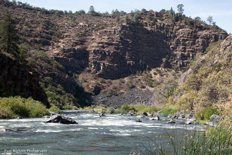
This section of the Pit River is in a deep canyon through a volcanic plateau. Upstream of this section, on top of the Modoc Plateau, the Pit River meanders through pastoral countryside. At Fall River Mills, the Pit is joined by Fall River and begins cutting a canyon. Over seven miles, the river cuts to the bottom of the plateau and exits onto another lower basin. Like the adjacent Upper Klamath, the Pit River has a basalt riverbed which is generally uncommon in California.
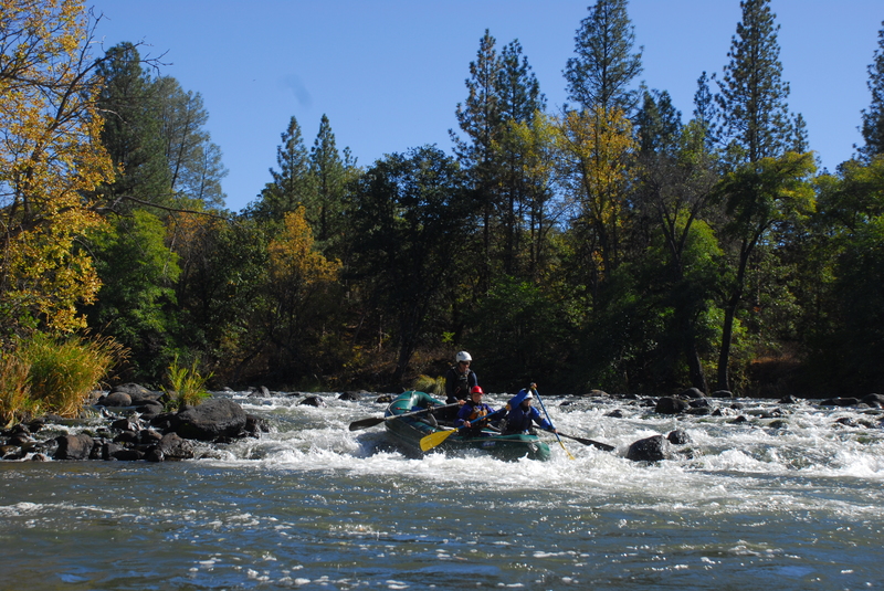
The Pit 1 reach is a great class IV+ run that has fall weekend releases, thanks to American Whitewater. Flows are normally diverted around this section for hydropower but during scheduled weekends in the fall, flows are restored to the river providing a great recreational resource for the community. This section also has boatable flows during periods of powerhouse maintenance (usually scheduled around the same time as the fall boating flows) and in winter or early spring when there's more water in the river than PG&E can divert for hydropower generation. American Whitewater also secured real-time flow information for this run to benefit the boating community. Note that release flows have a 7-8hr travel time to the gauge so it may not accurately reflect the current reach conditions or may read as low during a recreational release.
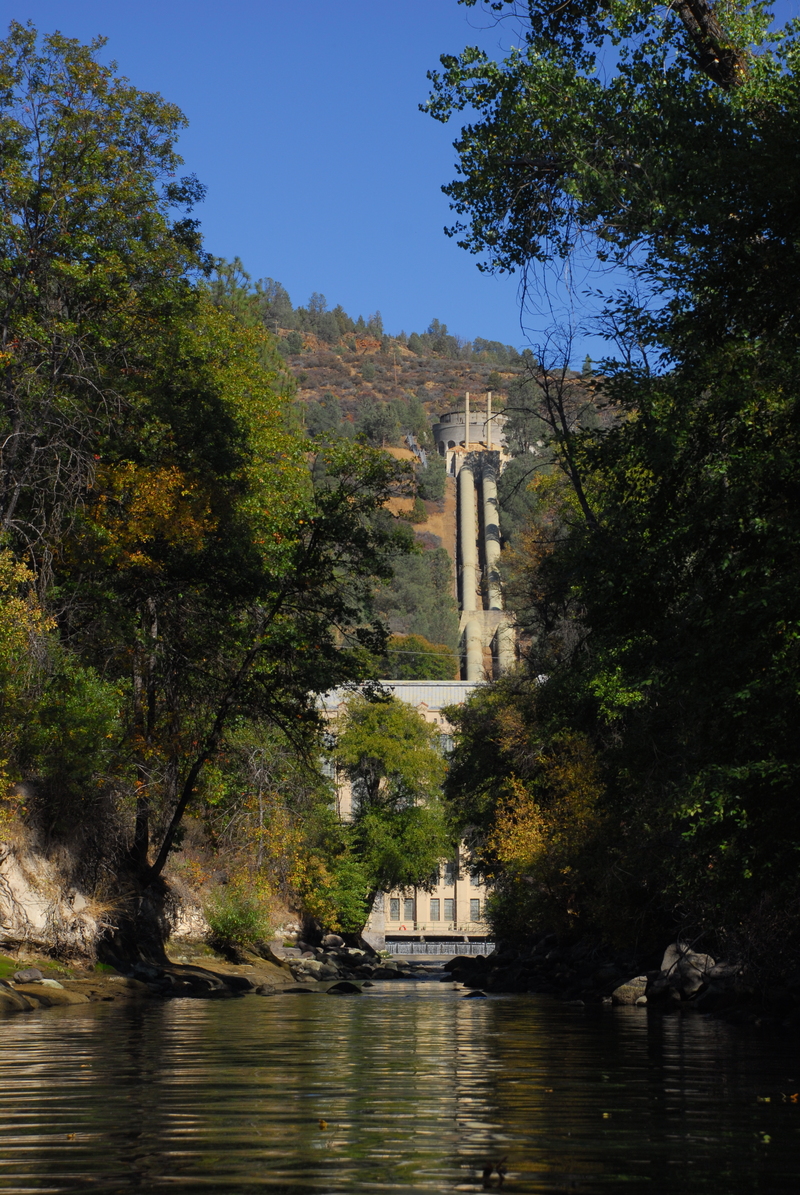
The put-in is on the river left across the bridge from Fall River Mills at a river access facility built and operated by PG&E. Use of the river access is free and there is a paved parking area, vault toilet, and short trail to the river.
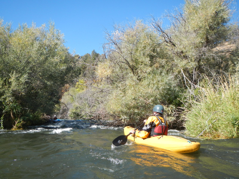
The first 1.8 miles on the water is a scenic, mosty flatwater warm-up before the whitewater begins. It takes about 20 minutes from the put-in to reach the first bona fide whitewater rapids. The old access closer to the start of the whitewater crossed private property and access here is no longer allowed: please do not trespass here.
Special Note:
Respect private property at all times. The riparian land along this section of the Pit is almost entirely private land and tribal land. All scouting and portages should be done in the river channel or below the ordinary high water mark. Bathroom facilities are located at the put-in and the take-out.
Whitewater Overview:
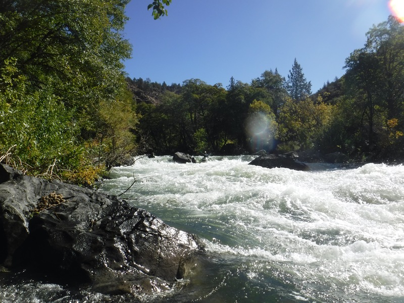
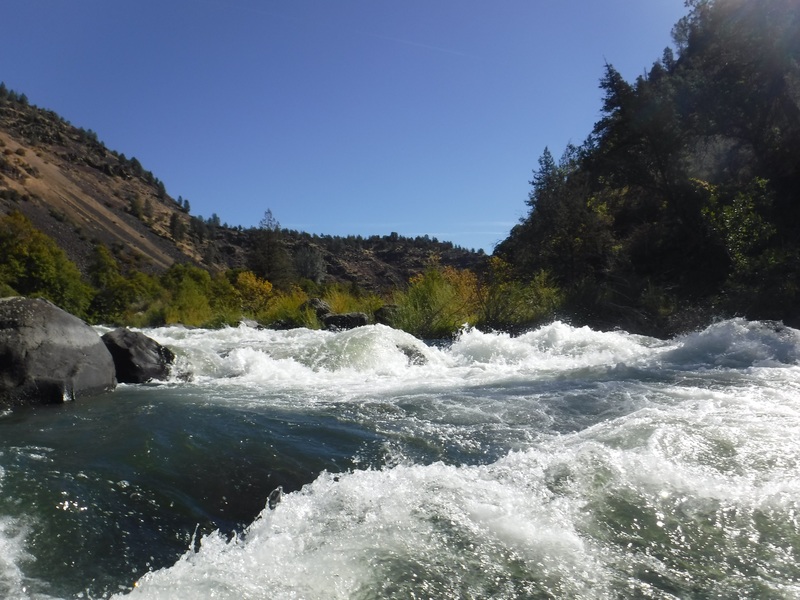
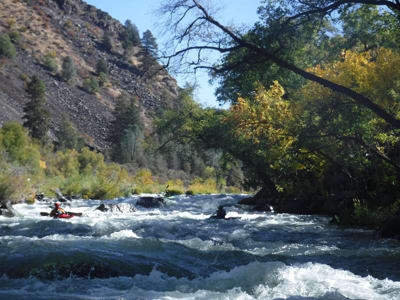
The flat water section ends abruptly at Big Eddy Estates. A wide volcanic band blocks the river and is covered with bushes and trees. A series of narrow channels flow downhill through the trees on far river right. The next 3 rapids are the steepest of the whole run, excluding Pit Falls. These rapids should be scouted as they have tricky moves that can't be seen from above. At flows of 800 and 1,100 cfs there are plenty of eddies. After the Big 3, the gradient eases and rapids open up enough for boat scouting everything else excluding Pit Falls.
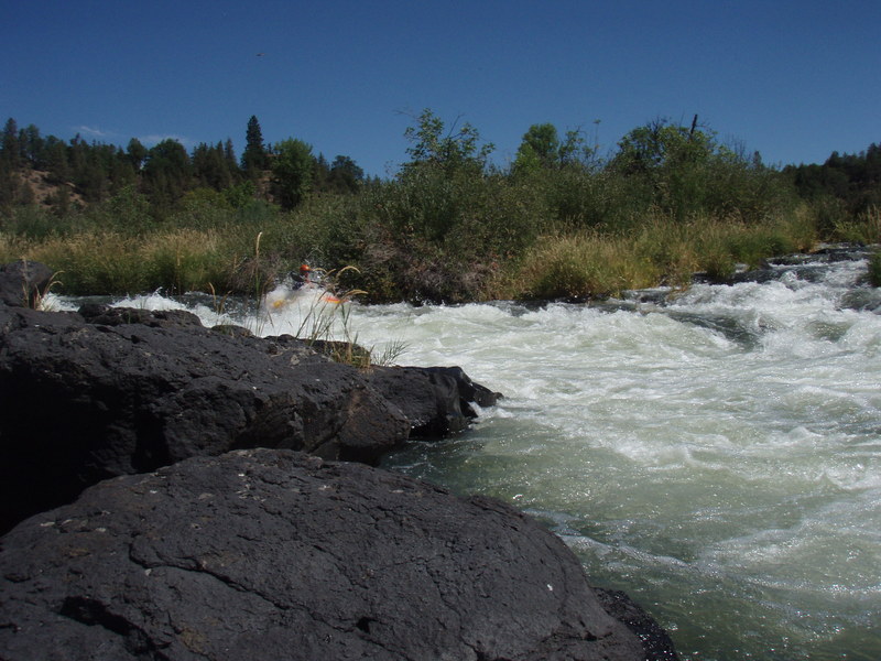
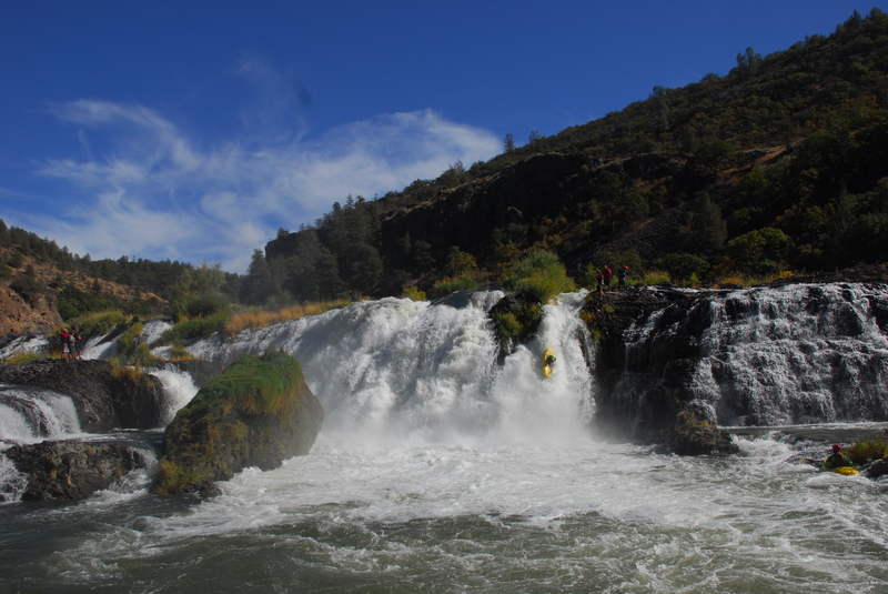
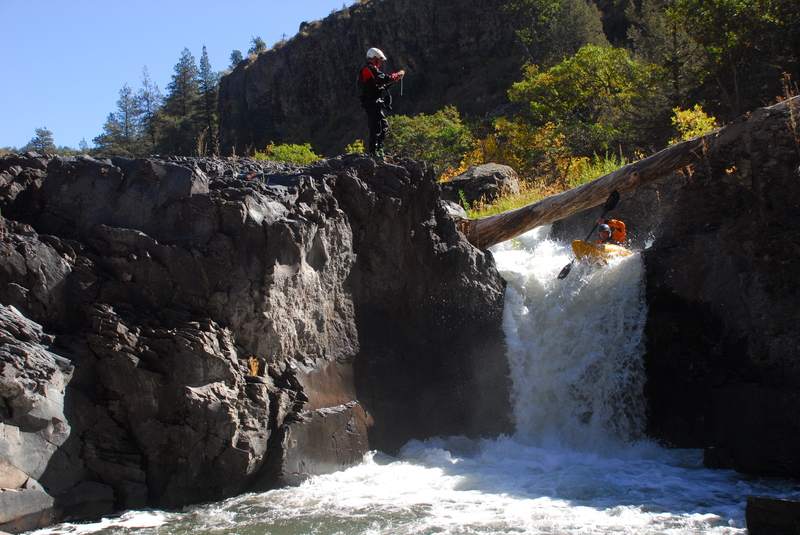
When the river begins to widen and approach a large right hand bend, exit the river on the right. At moderate flows walk in the shallows to a portage at the right edge of the falls. You can also climb a short steep bank to an old roadbed to get great views of the falls. You can continue walking along the roadbed to the old steel bridge. There is also a fairly easy portage on river left, between a 'fish ladder' channel and the main falls. The Falls tend to be run at three locations: a slide on the right, the 'Fish Ladder' on the left, and at some flows down high narrow chute left of center.
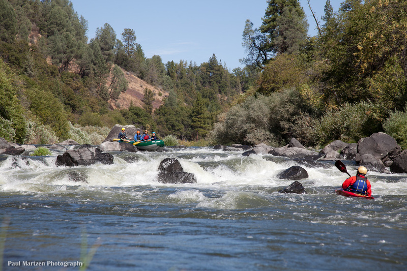
Below Pit Falls there's a series of easy drops called 'the lefts,' all on left hand bends with the normal routes to the left as well. Below this is the Longest Rapid of the Run. Although not as steep as the Big 3, it is steep enough and extends for 4/10s of a mile. Easier yet very busy rapids continue past the end of the canyon and to the take-out.
On Highway 299, between the put-in and take-out, there is a designated scenic overlook parking area with a good view of Pit Falls. There are also a series of turnouts west of the overlook that provide views of the lower rapids.
BLM Pit River Campground Take-out
Continue east on 299E to the turn off for the Pit #1 powerhouse. Turn right here if you wish to take out at the campground.
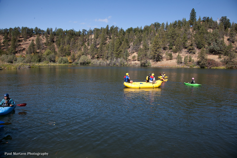
Boaters can also continue down into the class 2, Pit River Campground to Lake Briton section and take out at the highway bridge over the river.
Put-in
From the campground take-out, drive 1.4 miles to 299, turn right and climb the grade toward Fall River Mills. Turn right in the middle of Fall River Mills (this is a small community and finding the river is easy). Follow the road across the bridge and turn right into the new river access site constructed by PG&E as a condition of the new hydropower license. Unfortunately, parking is somewhat limited and there is no room for trailer parking, so be sure to link up with other boaters to reduce your parking footprint.
The old put-in used by whitewater boaters at 'Big Eddy Estates' is no longer allowed as of 2012. Please do not trespass here!
Camping
Pit River Campground has eight regular sites and one group site. Each site has a concrete picnic table and a fire ring. Regular sites are $8 per site per night and the group camp site is $12 per night. Sites are first come first served and there are no reservations. There are two pit toilets. There is no drinkable water supplied at the campground, so bring plenty. There is a clear spring a few hundred yards downstream at a Lions Club picnic area. The campground host is very helpful.
Three leaf sumac (Rhus trilobata) grows thick around the campsites. The stems are often used for basket making and it has edible berries. It looks very similar to poison oak as they are both in the sumac family. Some poison oak also grows in the area, so study them carefully to learn the difference. Many people have allergic reactions to poison oak, but but most people will not have any problems with three leaf sumac.
Supplies
Fall River Mills has a gas station, large grocery store, several resteraunts, a single screen movie theater, auto parts store, and other amenities. Nearby, Burney has several reasonably priced gas stations, a Safeway market, auto repair shops, etc.
Other Information Sources:
A Wet State
CaCreeks.com
Pit River Alliance
Trip Reports:
PITFALLS ON THE PIT
Neal Nikirk
Actually it is Pit Falls on the Pit #1 Bypass Reach of the Pit River, east of Burney, California (north of Lassen National Park). This is a rare opportunity for you to push your boat (minus you, preferably) over a 20 foot waterfall, collect it at the bottom, and lower it another 10 feet over the second part of the drop. More on this later…
The Pit#1 Bypass Reach is normally dewatered by PG&E operations, but due to the efforts of American Whitewater (AW), water is restored to this reach in October. We decided to sample this reported Class IV- run with one portage at Pit Falls. We, being Lacey and I in our small cats and our friend John form Ashland in his slightly larger cat. We met up at the BLM Pit River campground, which also serves as the take-out for this run and the put-in for a short Class II stretch downstream.
Luckily for us, Dave Steindorf of AW was camped there as well and intended to run his raft down on Saturday. Since he is a veteran of this run in both rafts and kayaks, we were fortunate to have him lead us down this stretch for our first time. One access point currently is at the bridge just south of Fall River Mills and involves a portageable weir and 3 miles of flatwater. We put in at the Big Eddy Estates \[no longer an option\], avoiding the flatwater ahead of the good stuff. All of us were on our best behavior as this put-in is on a private easement. There was a sign there indicating that for 2010 this arrangement could change. AW has been working with PG&E to provide an alternate access point, but to date, there is none. \[Access at Big Eddy Estates is no longer allowed. Launch at the bridge in Fall River Mills instead. ed. 2012\]
The whole run is relatively unique in that the rapids are formed where volcanic ledges have been cut by the river. Also, having only minimal flows most of the year allows lots of vegetation to grow in the channel. The upper two miles or so (above Pit Falls) is very interesting Class III+ to IV whitewater, weaving through a variety of reed-lined channels and over sharp (literally) ledges. It was great having Dave in the lead as he seemed to know which channels were clear, something that was NOT obvious from the river. Some of the other choices ended in steep boulder-choked drops that would have been nearly impassable or had trees across them. Not a place you wanted to end up accidentally.
Pit Falls is magnificent. A river wide volcanic ledge where the river has cut many channels over this 30 foot drop. Choose the wrong one and you’re toast. We opted to portage along the right, pushing the boats over a 20 foot slide into a shallow pool at the bottom. Sounds easy, right? WRONG. Getting the boats to the slide involves sliding them over and through the reeds along the bank. In several places there are DEEP channels that have been cut and lead to nasty places on the falls. We used the boats to “ladder” across a particularly bad channel just to reach the point where we could shove the boats out into the current for the slide. A mis-step here and you would go down the WRONG side of the slide and be seriously injured or killed. We managed to get the raft and one cat down the right side of the slide, while the other two cats decided (on their own) to run the wrong side. As is often the case, the empty boats made it fine. If people had been on them, the outcome could have been disasterous. Yes, the slide has been run by kayakers and paddle boats, but the prudent thing to do is portage. We then lowered the boats over the last 10 foot ledge to the main river below. Expert kayakers are routinely running the 20 foot slide on river right and a harder 30 foot plunge to the left.
Below the falls, are a few more miles of good Class III-III+ whitewater with multiple drops on left-hand bends, where the run is usually to the left as well. Except now there is a tree across the left channel in one of them…Take out at the BLM park below the Pit #1 Powerhouse channel. It is best to use the far right channel at the last drop to drop into the eddy. Too far left and you may get swept downstream into the Class II section for another hours river time. The class II section retains some of the “flavor” of the upper section in a user friendly environment. It is much more pool and drop with lots of flatwater. A few channels to choose from and an easy take-out at the Highway 299 bridge.
Overall, this run is very fun, with the portage at the falls being a bit sketchy. It is probably better suited to skilled kayakers than rafters. Dave and his raft got stuck quite a few times, but the cats had better runs as they were much lighter and more maneuverable. Our small, narrow cats were an advantage as there are several “chutes” to negotiate where wider boats have more difficulty. John’s wider cat perched on several rocks that we were able to slip between with our narrower boats. This is definitely a Class IV- run; fun and technically challenging. If you are not ready for the Chamberlain Falls run on the NF American or the Lumsden run on the Tuolumne, then you may not be ready for this one. The Falls are a thrill to be sure and beautiful to view.
Keep posted on what is happening on the Pit and when the releases will occur in 2010 by checking in on the American Whitewater website. This is a great organization and the main reason why we now have recreational releases on the Pit, NF Feather, NF Mokelumne, etc. Become a member and support a worthwhile cause!
Neal, 2009
FERC information:
Pit #1 project is FERC Project # 2687, and received a new license in 2003. Use the FERC search page to find documents related to this project. Enter P-2687 as the document number.
USFWS request to cancel flushing flows. pdf
AW response, defending flows. PDF
Other Rivers in the region that might have flows during release periods:
Pit River Campground to Lake Briton.
Upper McCloud
Clear Creek
Trinity
Other Points of Interest in the Area:
MacArther-Burney Falls State Park
Lassen National Park
Rapids in this Run (13)
 Rapid
Rapid
Start of whitewater
 Rapid
III
Rapid
III
Bushy Chutes
Rapid
III
Small Ledge
 Rapid
III+
Rapid
III+
Typewriter
Rapid
III+
Mary Go Round
 Rapid
IV+
Rapid
IV+
Unhappy Ending
Rapid
Spring
 Rapid
III
Rapid
III
Approach to Pit Falls
 Rapid
III
Rapid
III
Pitbull
 Rapid
IV
Rapid
IV
Quarter Mile Rapid- Egg Beater
 Rapid
III
Rapid
III
Wave Rapid
 Rapid
Rapid
Powerhouse Outlet Channel
 Rapid
II
Rapid
II
Campground Rapid
Waterfalls (3)
Hazards & Portages (3)
Caution: The following locations may require scouting or portaging. Always check current conditions.
Difficulty
Class III-IV+(V)
Length
7.0 mi
Rapids
13
3 Hazards
Access Points
Difficulty Classes
I Easy
II Novice
III Intermediate
IV Advanced
V Expert/Extreme
VI Unrunnable
Current Conditions
5-Day Forecast
Whitewater data from
American Whitewater
American Whitewater