FS Route 9N60 to Mt. Aukum Road
Linked via: Nhdplus created 95% confidence Synced 6mo ago
Gauge Conditions
Runnable: ? – ? CFS
Approximate reading: This gauge is 9.5 miles away on Cosumnes. Use as a general reference only.
Data from American Whitewater & USGS
Run Map
Run Time Estimate
Select put-in and take-out to estimate time.
Unlock Advanced Trip Planning
See wind-adjusted speed maps, forecast planning, and detailed time estimates.
Sign in to generate an AI timing estimate for this run.
Whitewater timing varies with scouting, portages, and group pace. Use as a planning baseline.
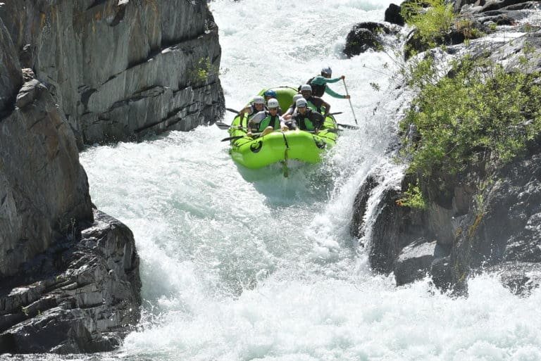
Description
The Upper Middle Cosumnes is an early spring run that is sought for the quality of its bedrock drops.
The Cosumnes drainage is to the south of Highway 50 between the Mokelumne and American rivers. It generally runs only in the winter or early spring since it does not have a high elevation drainage.
Getting There: The upper middle fork Cosumnes is near Sommerset, south of Placerville on Highway 50. One route is to take Cedar Ravine Road south from Placerville to Bucks Bar Road to Summerset.
Put in: From Sommerset go east on Grizzly Flat Road, Right on Caldor, Right on 9N60 and follow to Dog Town Creek. Walk five minutes across Dog Town Creek and to the UMC. This put in is on the river right.
Warning:
Put in options on river left are in question as local landowners have posted no tresspassing signs and have actively told boaters to go away. Landowners intend to gate the put in road to prevent access by non land owners. (May 2010)
Take out: There are several take out options. Rocky Bar Road on river right to the river is 4WD. A Toyota Tacoma and Tundra bottomed out multiple times getting down there. You may be able to drive most of the way down the right side take out road and then just hike your boats up a mile or less to the waiting vehicles. Try the traditional river left take out with a 20 minute longer shuttle to get back over to river right and get to put in.
Another option that isn't bad is to continue on the river down to the bridge at Mt Aukum Road. It adds 4 or 5 miles of class 3 to class 2 floating. If you're trying to save gas, this is a good option.
Other Information Sources:
Blog by David Maurier
Jefferson State Creeking A Wet State Boof.com access discussion 1
Boof.com access discussion 2
Rapids in this Run (1)
Difficulty
Class V
Length
10.8 mi
Rapids
1
Access Points
Shuttle Info
**Put in**: Take Grizzly Flat Road, Right on Caldor, Right on 9N60 and follow to Dog Town Creek. Walk five minutes across Dog Town Creek and to the UMC
Difficulty Classes
I Easy
II Novice
III Intermediate
IV Advanced
V Expert/Extreme
VI Unrunnable
Current Conditions
5-Day Forecast
Whitewater data from
American Whitewater
American Whitewater