Gasser Road to CTH.W (1.8 miles)
Linked via: Nhdplus discovery 90% confidence Synced 6mo ago
Gauge Conditions
Primary
Runnable: 2.0 – 4.0 IN/24H
Likely high (but will drop quickly).
Data from American Whitewater & USGS
Run Map
Run Time Estimate
Select put-in and take-out to estimate time.
Unlock Advanced Trip Planning
See wind-adjusted speed maps, forecast planning, and detailed time estimates.
Sign in to generate an AI timing estimate for this run.
Whitewater timing varies with scouting, portages, and group pace. Use as a planning baseline.
Description
This area was known almost exclusively by locals until it was named as a State Natural Area. Popularity blossomed, and abuse followed. A few major injuries (to cliff jumpers by the rocks of the dells, and to the rocks of the dells by cliff jumpers and others scrambiling all through the dells) has led to fences and signs restricting access to be anywhere but very limited viewing areas. Despite that, there are reports of people continuing to cliff jump and otherwise violate the present restricitons in this area.
What follows is description from before all the restrictions were put in place.
=================================================================================
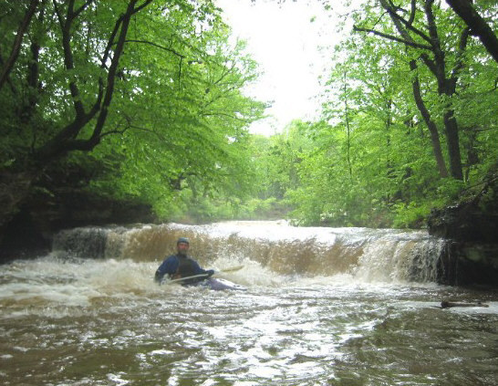
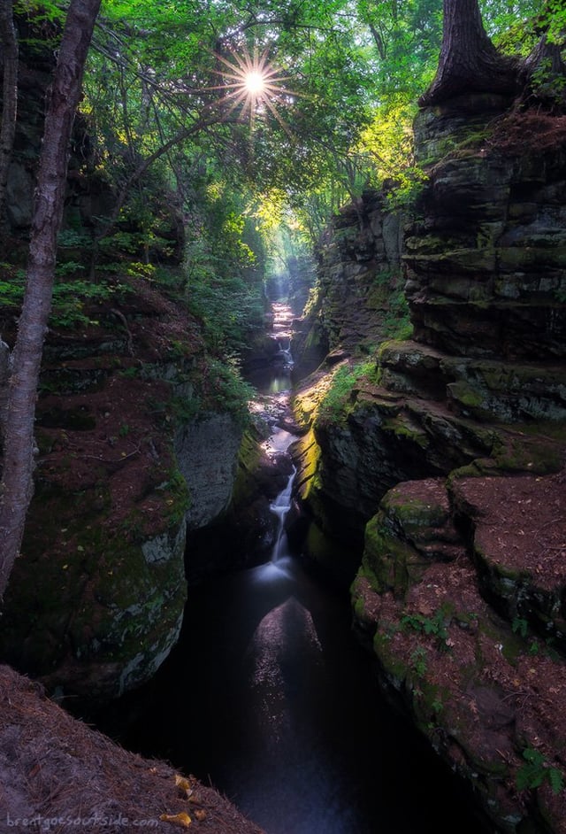
This unbelievable run starts out passing through a cow yard (this is Wisconsin!), where you'll have to negotiate two fences crossing the stream. Not long thereafter you'll encounter the opening sequence of drops which wouldn't be out of place in the U.P. (Michigan), followed by a 'middle stretch' of swiftwater (littered with numerous snags to be negotiated), followed by a little sandstone gorge (Pewit's Nest) which contains a sweet set of drops.
Do not take these drops too lightly. Your only view of the drops is from well overhead (climbing on or jumping from rocks is prohibited). From that high-overhead vantage point, it is nearly impossible to get an accurate perspective as to what the drops are actually like at river level. If all goes well (on your run), it's just a quick flush rush! (A piece-of-cake.) If anything goes amiss, you are in a nasty spot. There is almost no way for any other boaters to provide much assistance if you have an 'out of boat experience'.
The creek is narrow enough through the two largest drops that there is no 'choice of a line'. You can choose your angle, choose your technique (try to boof, or just drop over and go deep), choose your boat (I recommend something not too short), but the only choice of a line is 'down the falls' or 'around the falls' (portage). Oh, by the way, at lower levels, be aware of major piton possibilities in the third drop in Pewit's Nest (the first of the two larger drops).
Pewit's Nest is a state designated 'Natural Area', which has only somewhat recently officially opened to the public. (Unofficially, it has been accessed by local residents for years.) With designation as a State Natural Area, there is concern about preservation of the 'natural-ness' of the area. No food or beverage (no picnicing) is allowed, and there are the restrictions regarding climbing on the rocks, though I'm not aware of any specific restrictions on being in the gorge (I.E., boating). For those who may choose to check this out and boat it, _please_ be on your best behaviour so as not to give anyone an excuse or reason to ban boating this little gem.
Besides the couple of photos on the 'Photos' tab here, there are some excellent Vimeo.
Waterfalls (2)
Difficulty
Class III-IV
Length
1.9 mi
Gradient
50 ft/mi
Rapids
0
Access Points
Difficulty Classes
I Easy
II Novice
III Intermediate
IV Advanced
V Expert/Extreme
VI Unrunnable
Current Conditions
5-Day Forecast
Whitewater data from
American Whitewater
American Whitewater