Goldmine Rd to Cty 550 (4 miles)
Linked via: Proximity 98% confidence Synced 6mo ago
Gauge Conditions
Primary
Runnable: 160.0 – 500.0 CFS
Almost certainly too low for whitewater run.
Data from American Whitewater & USGS
Run Map
Run Time Estimate
Select put-in and take-out to estimate time.
Unlock Advanced Trip Planning
See wind-adjusted speed maps, forecast planning, and detailed time estimates.
Sign in to generate an AI timing estimate for this run.
Whitewater timing varies with scouting, portages, and group pace. Use as a planning baseline.
Description
Quick Facts:
Location: 13 miles NW of Marquette.
Shuttle Length: 4.7 miles. (See details in "Directions" Tab.)
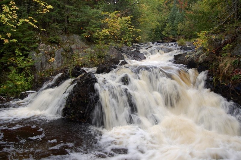
Character: Northwoods bobble, with chunks of gradient in ledges and slides.
Put-in is approximately 964' elevation.
Take-out is approximately 648' elevation.
Thus total elevation change is approximately 316'.
* * *
This tiny river tends to take its gradient in big chunks. There are four sections of elevated gradient, each dropping 50-60' fairly quickly.
Unfortunately, the lower portion of the first good gradient sequence is essentially unrunnable due to an overhanging rock at the bottom of a tight, steep slot/flume. (Can you say 'high speed cranial impact'?)
The not-so-steep portions of the run are essentially a pleasant bobble through the woods, and are _fairly_ clear of wood for a stream this small. However, logs tend to gather in quantity in some of the drops, rendering them unrunnable in part or whole. As a result (when we were there) a wonderful sliding drop mid-run had a huge tree across midway down, so we had to settle for sliding off shore to run just the bottom half.
The final big drop may be runnable at some flows, but most of the water slides into an overhanging wall in such a way as to dissuade most folks at most flows. This falls could be seen by walking several hundred yards up from the 550 bridge but keep in mind that here (as along much of this run) the property is privately held.
Bottom line? We did it once, and it was interesting to explore and see its drops, but it's doubtful it will make anyone's _'must do again'_ list.


Difficulty
Class III-V
Length
3.4 mi
Gradient
80 ft/mi
max 130
Rapids
6
Access Points
Difficulty Classes
I Easy
II Novice
III Intermediate
IV Advanced
V Expert/Extreme
VI Unrunnable
Current Conditions
5-Day Forecast
Whitewater data from
American Whitewater
American Whitewater