Hayman Falls (0.5 mile)
Linked via: Proximity 66% confidence Synced 6mo ago
Gauge Conditions
Runnable: 600.0 – 4,000.0 CFS
Probably too low for any reasonable whitewater.
Data from American Whitewater & USGS
Run Map
Run Time Estimate
Select put-in and take-out to estimate time.
Unlock Advanced Trip Planning
See wind-adjusted speed maps, forecast planning, and detailed time estimates.
Sign in to generate an AI timing estimate for this run.
Whitewater timing varies with scouting, portages, and group pace. Use as a planning baseline.
Description
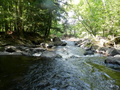
This is essentially one half-mile rapid (I.E., not a true falls as the name suggests), and is most often run as a companion piece to some of the other short runs in the area. After entering the park, drive to the end of the parking lot and carry up the hill. You may notice a sign reading "Dam" on the far side of the river near the put-in. This is about the only remainder of the former hydroelectric dam that was at this location.
The rapids sequence starts with minor bedrock intrusions which form several tame surfing waves (one of which is usually wide enough to entertain three or four boaters at once). Just downstream the river drops off a sloping ledge of about 5' and slams into a large boulder near center stream. Normally this is run to the right but there is an eddy to the left at the bottom if you're up for the ferry across the face of the rock.
After a brief recovery zone, the river tilts downhill again through some boulders. The second set are nicely offset, making for an interesting variety of lines. At high flows, these boulders become pourovers that you'll probably want to avoid. Just downstream, the river bends to the right, with wood often collecting in the outside of the bend (a potential hazard to be aware of especially if someone swims). As the river approaches the bridge into the park, it eases back into the lazy mode it has along much of it's length. Take-out on the right upstream of the bridge and, if you're like us, you'll probably want to carry back up and do it again.
As this reach is fairly short, you may wish to combine it with one or more of these other reaches which are close by for a Shawano County double or triple header.
- Tigerton Dells
- Rocky Run
- Upper Red
- Lower Red
Rapids in this Run (1)
Difficulty
Class III
Length
0.4 mi
Gradient
38 ft/mi
Rapids
1
Access Points
Shuttle Info
Shuttle is via walking back up in the park.
For this reason, we have set the directions here to show drive time, distance, and directions from your default zipcode. Use the text entry box to input your home or other starting location to get travel time, distance, and directions from any location to this park.
Difficulty Classes
I Easy
II Novice
III Intermediate
IV Advanced
V Expert/Extreme
VI Unrunnable
Current Conditions
5-Day Forecast
Whitewater data from
American Whitewater
American Whitewater