Gauge Conditions
Runnable: 160.0 – 260.0 CFS
Data from American Whitewater & USGS
Run Map
Run Time Estimate
Select put-in and take-out to estimate time.
Unlock Advanced Trip Planning
See wind-adjusted speed maps, forecast planning, and detailed time estimates.
Sign in to generate an AI timing estimate for this run.
Whitewater timing varies with scouting, portages, and group pace. Use as a planning baseline.
Description
Park at the Isinglass Recreation Area parking lot operated by the nearby Waste Management company. The area features a number of loop trails that locals use to walk their dogs, jog, and ride bikes. Most trails lead to the falls, but the quickest route is to take the trail to the right as you're facing the main sign, and then the first left. Follow your intuition and your ears to the falls (down hill), maybe a 5 minute walk.
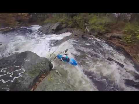
The falls itself features a tricky lead-in, with much of the water pushing into a rock face on river left before pouring roughly 12-15 feet vertically into a meaty hole. At lower flows, around 170, it's difficult to run a straight line on the drop as their are guard rocks. Lower than that is really tricky to get on line. The water pushes left to right across the lip and it's shallow.
The fall-line is split two-thirds of the way from the left bank by a large protruding rock. This rock divides the flow and forms a sloping/curving chute down the right side.
There is a large pool at the bottom. Locals dive into this pool at low water and I am told it is very deep. There is a small shelf on the right at the bottom of the main drop. Go off the tongue left of center for guaranteed deepness. Or get a boof stroke in about 1/3 of the way down the tongue.
I'm sure it was run before we did it, but Brooke Sofferman and I put it on the books November, 2014.
-C
Description and photos by Clinton Begley
Waterfalls (1)
Difficulty
Class IV
Length
0.1 mi
Rapids
0
Access Points
Shuttle Info
From Calef Highway, turn south onto Rochester Neck Road. After about a mile, look to the right to the obvious parkinglot. If you hit the turn for Waste Management's primary facility on the right, you've gone too far.
Difficulty Classes
I Easy
II Novice
III Intermediate
IV Advanced
V Expert/Extreme
VI Unrunnable
Current Conditions
5-Day Forecast
Whitewater data from
American Whitewater
American Whitewater